Maps of Siberia
Carte géographique contenant le royaume de Siberie
1 : 13000000 Asie střední Lotter, Matthäus Albrecht publiée par Tobie Conrad Lotter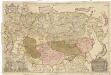
Nova descriptio geographica Tattariae magnae tam orientalis quam occidentalis in particularibus et generalibus territoriis una cum delineatione totius imperii Russici imprimis Siberiae accurate ostensa
1 : 6730000 Asie Strahlenberg, Philipp Johann von Frisch, P. J.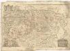
Nova descriptio geographica Tattariae Magnae tam orientalis quam occidentalis in particularibus et generalibus teritoriis una cum delineatione totius imperii Russici imprimis Siberiae accurate ostensa
1 : 6730000 Asie Strahlenberg, Philip Johan von Frisch, P. J.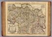
Carte de Tartarie.
1 : 10700000 L'Isle, Guillaume de, 1675-1726
Carte de Tartarie.
1 : 10700000 L'Isle, Guillaume de, 1675-1726
Ethnographische Karte des Asiatischen Russlands
Russland Russland / Asiatischer Teil Ethnische Gruppe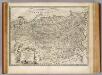
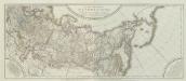
Russian Empire.
1 : 16500000 Bowen, Emanuel
Paasche's Frontenkarte, Nr. 25 Russland, Italien, Balkan u. Orient
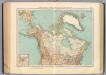
125-26. Canada, Alasca, Groenlandia.
1 : 15000000 Touring club italiano
Imperii Russici et Tartariae universae tam majoris et Asiaticae, qvam minoris et Europaeae tabvla
1 : 16820000 Asie Hase, Johann Matthias Schneider, R. A. impensis Homannianorum Heredum
Russia in Asia and Tartary.
1 : 19500000 Mitchell, Samuel Augustus
Russia in Asia and Tartary.
1 : 19500000 Mitchell, Samuel Augustus
Great Tartary.
1 : 26000000 Moll, Herman, d. 1732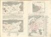
Sovětský svaz v mapách

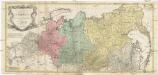
Nouvelle carte de Moscovie où sont representés les diferents etats de Sa Maiesté Czarienne en Eur
1 : 13000000 1 Karte : Kupferdruck ; 40 x 56 cm Châtelain, Zacharias [Verlag nicht ermittelbar]
Nouvelle carte de Moscovie où sont representés les diferents etats de Sa Maiesté Czarienne en Eur
1 : 13000000 1 Karte : Kupferdruck ; 40 x 56 cm Châtelain, Zacharias [Verlag nicht ermittelbar]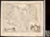
Tartaria sive Magni Chami imperivm
1 : 13000000 1 Karte : Kupferdruck ; 38 x 50 cm [Blaeu]
Tartaria sive Magni Chami imperiorum
1 : 14000000 1 Karte : Kupferdruck ; 25 x 33 cm Blaeu, Joan [Merian]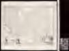
Tartaria sive Magni Chami imperiorum
1 : 14000000 1 Karte : Kupferdruck ; 25 x 33 cm Blaeu, Joan [Merian]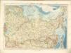
Sovětský svaz v mapách

Generali totius imperii Russorum novissima tabula
1 : 11940000 Japonské moře Homann, Johann Baptist ex conatibus Iohannis Baptistae Homanni
Imperii Russici et Tatariae universae tam majoris et Asiaticae, qvam minoris et Europaeae tabvla
1 : 17200000 Asie Hase, Johann Matthias Schneider, R.A. impensis Homannianorum Heredum
IMPERII RUSSICI et TATARIAE UNIVERSAE tam majoris et Asiaticae, qvam minoris et Europaeae TABVLA
1 : 17200000 Asie Hase, Johann Matthias impensis Homannianorum Heredum
Sovětský svaz v mapách
Carte de Tartarie / dressée sur les relations de plusieurs voyageurs de differentes nations et sur
1 : 11100000 1 Karte : Kupferdruck ; 47 x 60 cm L'Isle, Guillaume de chez I. Cóvens et C. Mortier
Carte de Tartarie / dressée sur les relations de plusieurs voyageurs de differentes nations et sur
1 : 11100000 1 Karte : Kupferdruck ; 47 x 60 cm L'Isle, Guillaume de chez I. Cóvens et C. Mortier
Tartaria sive Magni Chami Imperium [Karte], in: Gerardi Mercatoris et I. Hondii Newer Atlas, oder, Grosses Weltbuch, Bd. 2, S. 353.
1 Karte aus Atlas Mercator, Gerhard und Hondius, Jodocus Jansson, Jan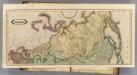
Asia. (N sheets)
1 : 12000000 Lizars, Daniel
Uebersichts-Karte der ethnographischen Verhältnisse von Asien und von den angrenzenden Theilen Europa'sbearbeitet und herausgegeben mit Unterstützung der kaiserlichen Akademie der Wissenschaften in Wien von Vinzenz v. Haardt
Hartenthurn, Vincenz