Maps of Landkreis Neumarkt in der Oberpfalz
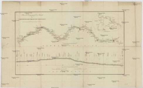
Plan und Laengenprofil des Kanals zur Verbindung des Rheins mit der Donau
1 : 375000 Bavorsko (Německo) Barraga
Nürnberg 115, uit: Special-Karte von Mittel-Europa / nach amtlichen Quellen bearbeitet von W. Liebenow
1 : 300000 titelvariant: W. Liebenow's Mittel-Europa; Annotatie: Titel boven de bladen: W. Liebenow's Mittel-Europa Johannes Wilhelm Liebenow 1822-1897 Frankfurt a. M. : Ludwig Ravenstein
C. Flemming's Karte von Deutsch - Französischen Kriegsschaupltze

Das Nürenbergische Gebiet mit allen Nürnbergischen Hauptmannschafften
1 : 200000 Norimberk-oblast (Německo) Scheurer, Christoph
Das Nürenbergische Gebiet
1 : 200000 Mollova mapová sbírka Scheurer, Christoph Seutter, Matthäus
Das Nürenbergische Gebiet
1 : 200000 Mollova mapová sbírka Scheurer, Christoph Seutter, Matthäus
Deutsche Strassenprofilkarte für Rad - und Autofahrer 58 Nürnberg

Mappa Geographica Territorii Sacri Romani Imperii liberae Civitatis Norimbergensis
1 : 150000 Mollova mapová sbírka Cnopf, Matthäus Ferdinand Hauer, Daniel Adam Homann, Johann Baptista - dědici
Territorii Novoforensis in svperiore palatinatu accurata descriptio
1 Karte : Kupferdruck ; 38 x 49 cm Rittershausen; Pitt; Swart; Janssonius van Waesbergen Janssonius van Waesbergen - Pitt - Swart
Pars prima continet partem marchion: Onoldin: palat: Sultzbac: Neoburg: episc: Aichstad: Reipubl: Nurimberg: et incertas regiones
1 Karte : 54 x 52 cm Heinrich Ludwig Broenner
Territorii Novoforensis in Svperiore Palatinatu accurata descriptio
1 : 120000 Mollova mapová sbírka Rittershausen, Nicolaus Schenk, Peter I
Episcopatus Aichstettensis, cum dynastiis et praefecturis suis ac viciniis hac geographica delineatione accuratè descriptus
1 : 180000 Mollova mapová sbírka Seutter, Matthäus Lotter, Tobias Conrad Seutter, Matthäus
Territorii Novoforensis In Superiore Palatinatu accurata descriptio [Karte], in: Novus atlas absolutissimus, Bd. 2, S. 232.
1 Karte aus Atlas Janssonius Offizin
Territorii Novoforensis in svperiore palatinatu accurata descriptio
1 Karte : Kupferdruck ; 39 x 49 cm Rittershausen; Schenk; Valck typis G. Valk et P. Schenk
Territorii Novoforensis in svperiore Palatinatu accurata descriptio / auctore Nicolao Rittershusio D
1 : 100000 Annotatie: Kaart toont het gebied rondom Neumark, Oberpfalz, tussen Nürnberg, Hilpoltstein, Burglengenfeld en Hohenburg; Origineel is Blad 125 in atlas factice Nicolaus Rittershausen 1597-1670 [Amsteladami : Ioannis Blaeu]
TERRITORII | NOVOFORENSIS | IN SVPERIORE PALATINATU | ACCURATA DESCRIPTIO
Auctore | Nicolao Rittershusio D. [Amsterdam : Joan Blaeu]

Nürnbergischer Bezirck
1 : 110000 Mollova mapová sbírka Scheurer, Christoph
Nürnbergischer Bezirck
1 : 110000 Mollova mapová sbírka Scheurer, Christoph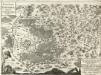
Territorium Norimbergense. Cum quibusdam adjacentibus locis
Mollova mapová sbírka Hoffmann, Johann
Territorium Norimbergense. [Karte] Nurnberg [1 Nebenkarte], in: Theatrum orbis terrarum, sive, Atlas novus, Bd. 1, S. 263.
1 Karte aus Atlas Blaeu, Joan Blaeu, Willem Janszoon
Territorium Norimbergense. [Karte] Nurenberg [Nebenkarte], in: Novus atlas absolutissimus, Bd. 2, S. 235.
1 Karte aus Atlas Janssonius Offizin
Norimberg. Agri, Fidissima Descrip.[Karte], in: Theatrum orbis terrarum, S. 241.
1 Karte aus Atlas Ortelius, Abraham Vrients, Jan Baptista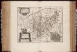
Territorivm Norimbergense
1 : 200000 Annotatie: Origineel is Blad 124 in atlas factice; Annotatie geografische gegevens: West boven; Inzet: Nurnberg Willem Jansz Blaeu 1571-1638 Amstelodami : exc. Guiljelm. Blaeuw
Territorium Norimbergense. [Karte], in: Le théâtre du monde, ou, Nouvel atlas contenant les chartes et descriptions de tous les païs de la terre, Bd. 1, S. 257.
1 Karte aus Atlas Blaeu, Willem Janszoon und Blaeu, Joan Blaeu, Willem Janszoon
Territorium Norimbergense. [Karte] Nurnberg., in: Novus Atlas, das ist, Weltbeschreibung, Bd. 1, S. 228.
1 Karte aus Atlas Blaeu, Joan Blaeu, Willem Janszoon
Territorivm Norimbergense
1 : 120000 Mollova mapová sbírka Schenk, Pieter Schenk, Peter I
Norimberg. Agri, Fidissima Descrip.[Karte], in: Theatrum orbis terrarum, S. 149.
1 Karte aus Atlas Ortelius, Abraham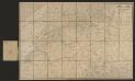
Territorium Norimbergense. [Karte] Nurnberg [Planvedute, Nebenkarte], in: Gerardi Mercatoris et I. Hondii Newer Atlas, oder, Grosses Weltbuch, Bd. 1, S. 310.
1 Karte aus Atlas Mercator, Gerhard und Hondius, Jodocus Jansson, Jan