Maps of Cheb District

Generalkarte der Bezirkshauptmannschaft Falkenau
1 : 220000 Sokolov-oblast (Česko) Wagner, Jan Eduard F. Kytka
Západočeské lázně

Eger und Falkenau.
from Spezialkarte der osterreichisch-ungarischen Monarchie.
II. vojenské mapování 11
1 : 144000
Geologische Uibersichtskarte vom Ursprunge der Eger bis Karslbad
Karlovy Vary (Česko)
Accurate abbildung der Statt Kayser Carlsbad, nach doppelten Prospect, und geograph. Situation in Böhmen in dem Elnbogner Crais gelegen samt angränzender Gegend und Landschafften
1 : 160000 mit sonderbarem Fleiß verfertiget von Matthaeo Seutter Augspurg : Matt. Seutter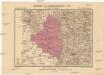
Generalkarte der Bezirkshauptmannschaft Eger
1 : 220000 Cheb-oblast (Česko) Wagner, Jan Eduard F. Kytka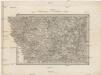
Umgebungen von Carlsbad und Eger
Cheb-oblast (Česko) Kiss, Josef K. u. k. Militärgeographisches Institut
Carlsbad mit dem Gantzen Ellenbogner Creisse im Königreiche Böhmen
1 : 360000 Mollova mapová sbírka Weigel, Christoph Weigel, Christoph I. - dědici
Eger und Falkenau
1 : 75000 Cheb (Česko : oblast) Höller, K. K. u. k. militär-geographisches Institut
Eger und Falkenau
1 : 75000 Cheb (Česko : oblast) Höller, K. K. u. k. Militärgeographisches Institut
Eger und Falkenau
1 : 75000 Cheb (Česko : oblast) K. u. k. Militärgeographisches Institut
Cheb
1 : 75000 Cheb (Česko : oblast) Vojenský zeměpisný ústav
III. vojenské mapování 3949
1 : 75000
Falkenauer Vicariat
Sokolov-oblast (Česko)
Morphologische Uebersichtskarte des Falkenauer Tertiärbeckens
1 : 120000 Sokolov (Česko : oblast) Peter, Josef
Cheb
1 : 75000 Cheb-oblast (Česko) Vojenský zeměpisný ústav
[Vilímkovy místopisné mapy zemí Koruny české]
1 : 100000 Karlovy Vary (Česko : oblast) Srp, Jan Jos. R. Vilímek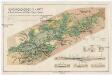
Montangeologische Karte der Braunkohlenreviere von Falkenau, Elbogen u. Karlsbad
1 : 50000 Karlovy Vary (Česko : oblast) Frieser, Antonín Adolf Becker
Montangeologische Karte der Braunkohlenreviere von Falkenau, Elbogen u[nd] Karlsbad
1 : 50000 Karlovy Vary (Česko : oblast) Frieser, Anton Adolf Becker
[Umgebung von Eger]
1 : 75000 Cheb (Česko : oblast) K. u. k. Militärgeographisches Institut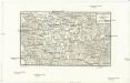
Franzensbrunn und Marienbad
Františkovy Lázně-oblast (Česko) Streit, Friedrich Wilhelm Müller, Leopold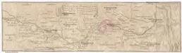
Marsch des k. frantzöischen Corpo, so Duc d'Mallabois com[m]andirt, wie weit selbiges in Böhmen avancirt A. 1742
1 : 247000 Cheb-oblast (Česko)
Karte der Bezirke Falkenau u. Graslitz
1 : 100000 Kraslice-oblast (Česko) Stelzig, Heinrich Heinr. Stelzig

Trigonometrisches Netz als Grundlage zur Charte vom Egerlande
1 : 112000 Cheb-oblast (Česko) Kreibich, František Jakub Jindřich David, Martin Alois
Lichtenstädter Vikariat
Hroznětín (Karlovy Vary, Česko)
Petrographische Charte des Egrischen Bezirks
1 : 120000 Cheb-oblast (Česko) Müller, Johann Christoph
Cheb a okolí
1 : 75000 Cheb (Česko : oblast) Vojenský zeměpisný ústav


