Maps of Česká Lípa

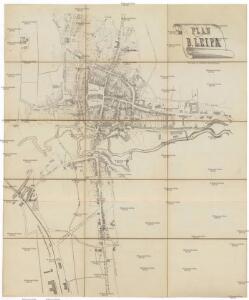
Plan von B. Leipa
Česká Lípa (Česko)
Böhmisch Leippa (Česka Ljpa) - c0954-1-007 - Kaiserpflichtexemplar der Landkarten des stabilen Katasters
1 : 2880
Böhmisch Leippa (Česka Ljpa) - c0954-1-004 - Kaiserpflichtexemplar der Landkarten des stabilen Katasters
1 : 2880
Böhmisch Leippa (Česka Ljpa) - c0954-1-005 - Kaiserpflichtexemplar der Landkarten des stabilen Katasters
1 : 2880
Böhmisch Leippa (Česka Ljpa) - c0954-1-006 - Kaiserpflichtexemplar der Landkarten des stabilen Katasters
1 : 2880
Böhmisch Leippa (Česka Ljpa) - c0954-1-001 - Kaiserpflichtexemplar der Landkarten des stabilen Katasters
1 : 2880
Böhmisch Leippa (Česka Ljpa) - c0954-1-002 - Kaiserpflichtexemplar der Landkarten des stabilen Katasters
1 : 2880
Böhmisch Leippa (Česka Ljpa) - c0954-1-003 - Kaiserpflichtexemplar der Landkarten des stabilen Katasters
1 : 2880
Alt Leippa (Stara Ljpa) - c7241-1-003 - Kaiserpflichtexemplar der Landkarten des stabilen Katasters
1 : 2880
Alt Leippa (Stara Ljpa) - c7241-1-002 - Kaiserpflichtexemplar der Landkarten des stabilen Katasters
1 : 2880
Alt Leippa (Stara Ljpa) - c7241-1-001 - Kaiserpflichtexemplar der Landkarten des stabilen Katasters
1 : 2880
Nieder Liebich - c1325-1-001 - Kaiserpflichtexemplar der Landkarten des stabilen Katasters
1 : 2880
Nieder Liebich - c1325-1-003 - Kaiserpflichtexemplar der Landkarten des stabilen Katasters
1 : 2880
Nieder Liebich - c1325-1-004 - Kaiserpflichtexemplar der Landkarten des stabilen Katasters
1 : 2880
Nieder Liebich - c1325-1-002 - Kaiserpflichtexemplar der Landkarten des stabilen Katasters
1 : 2880
Schwora - c7575-2-002 - Kaiserpflichtexemplar der Landkarten des stabilen Katasters
1 : 2880
Schwora - c7575-2-003 - Kaiserpflichtexemplar der Landkarten des stabilen Katasters
1 : 2880
Schwora - c7575-2-004 - Kaiserpflichtexemplar der Landkarten des stabilen Katasters
1 : 2880
Schwora - c7575-2-005 - Kaiserpflichtexemplar der Landkarten des stabilen Katasters
1 : 2880
Schwora - c7575-2-001 - Kaiserpflichtexemplar der Landkarten des stabilen Katasters
1 : 2880
Schönborn - c7413-1-002 - Kaiserpflichtexemplar der Landkarten des stabilen Katasters
1 : 2880
Schönborn - c7413-1-001 - Kaiserpflichtexemplar der Landkarten des stabilen Katasters
1 : 2880
Schönborn - c7413-1-004 - Kaiserpflichtexemplar der Landkarten des stabilen Katasters
1 : 2880
Schönborn - c7413-1-003 - Kaiserpflichtexemplar der Landkarten des stabilen Katasters
1 : 2880

III. vojenské mapování 3753/1
1 : 25000
[Kartenblatt]
1 : 25000 Žandov (Česká Lípa, Česko : oblast) Reichsamt für Landesaufnahme
Landkreis Böhm[isch] Leipa
1 : 75000 Protektorát Čechy a Morava Dienststelle für Raumordnung und Landesplanung beim Regierungspräsidenten
Special Karte des politischen Amtsbezirkes Böhm. Leipa
Česká Lípa-oblast (Česko) Jos. Hamann