Maps of Bor
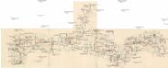
Böhmerwald-Verbindungsbahn
1 : 75000 Domažlice-Planá u Mariánských Lázní (Česko : železniční trať) Technisches Bureau Ing. Max Picha


III. vojenské mapování 4149/4
1 : 25000
[Kartenblatt]
1 : 25000 Bělá nad Radbuzou (Česko : oblast) Reichsamt für Landesaufnahme
[Kartenblatt]
1 : 25000 Bor (Tachov, Česko : oblast) Reichsamt für Landesaufnahme
Gradkartenblatt
1 : 25000 Přimda-oblast (Česko) Bulla, Eduard
III. vojenské mapování 4149/2
1 : 25000
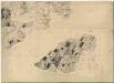
Přehledová mapa velkostatku Tachov
1 : 17280

Přehledná porostní mapa borských lesů k lesní prohlídce konané lesnickým spolkem
1 : 10000
Mapa panských pozemků v katastru obce Postřekov
1 : 5760
Gradkartenblatt
1 : 25000 Klenčí pod Čerchovem-oblast (Česko) Bulla, Eduard
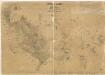
Přehledová mapa velkostatku Kladruby
1 : 17280
Přehledná mapa kultur velkostatku Kout-Trhanov
1 : 51605
Přehledová mapa panství Trhanov se Staněticemi a Zahořany
1 : 21072
[Kartenblatt]
1 : 25000 Klenčí pod Čerchovem (Česko : oblast) Reichsamt für Landesaufnahme
III. vojenské mapování 4249/2
1 : 25000
III. vojenské mapování 4249/2
1 : 25000
III. vojenské mapování 4249/2
1 : 25000
Mapa panských pozemků v polesí Postřekov
1 : 5760
Porostní mapa revíru Sedmihoří
1 : 20000
Porostní mapa revíru Olešná
1 : 8640
Přehledná mapa vrchnostenských pozemků v katastru města Bor
1 : 8640
Porostní mapa revíru Výrov
1 : 12315
Hospodářská mapa revíru Výrov
1 : 12396
Alt u. Neu Possigkau - c6041-1-016 - Kaiserpflichtexemplar der Landkarten des stabilen Katasters
1 : 2880
Alt u. Neu Possigkau - c6041-1-009 - Kaiserpflichtexemplar der Landkarten des stabilen Katasters
1 : 2880
Alt u. Neu Possigkau - c6041-1-002 - Kaiserpflichtexemplar der Landkarten des stabilen Katasters
1 : 2880
Alt u. Neu Possigkau - c6041-1-007 - Kaiserpflichtexemplar der Landkarten des stabilen Katasters
1 : 2880
Alt u. Neu Possigkau - c6041-1-008 - Kaiserpflichtexemplar der Landkarten des stabilen Katasters
1 : 2880
Alt u. Neu Possigkau - c6041-1-012 - Kaiserpflichtexemplar der Landkarten des stabilen Katasters
1 : 2880
Alt u. Neu Possigkau - c6041-1-005 - Kaiserpflichtexemplar der Landkarten des stabilen Katasters
1 : 2880
Alt u. Neu Possigkau - c6041-1-017 - Kaiserpflichtexemplar der Landkarten des stabilen Katasters
1 : 2880
Alt u. Neu Possigkau - c6041-1-018 - Kaiserpflichtexemplar der Landkarten des stabilen Katasters
1 : 2880
Alt u. Neu Possigkau - c6041-1-003 - Kaiserpflichtexemplar der Landkarten des stabilen Katasters
1 : 2880
Alt u. Neu Possigkau - c6041-1-001 - Kaiserpflichtexemplar der Landkarten des stabilen Katasters
1 : 2880
Alt u. Neu Possigkau - c6041-1-014 - Kaiserpflichtexemplar der Landkarten des stabilen Katasters
1 : 2880
Alt u. Neu Possigkau - c6041-1-004 - Kaiserpflichtexemplar der Landkarten des stabilen Katasters
1 : 2880
Alt u. Neu Possigkau - c6041-1-010 - Kaiserpflichtexemplar der Landkarten des stabilen Katasters
1 : 2880
Alt u. Neu Possigkau - c6041-1-013 - Kaiserpflichtexemplar der Landkarten des stabilen Katasters
1 : 2880
Alt u. Neu Possigkau - c6041-1-006 - Kaiserpflichtexemplar der Landkarten des stabilen Katasters
1 : 2880
Alt u. Neu Possigkau - c6041-1-015 - Kaiserpflichtexemplar der Landkarten des stabilen Katasters
1 : 2880


