Maps of Příčovy
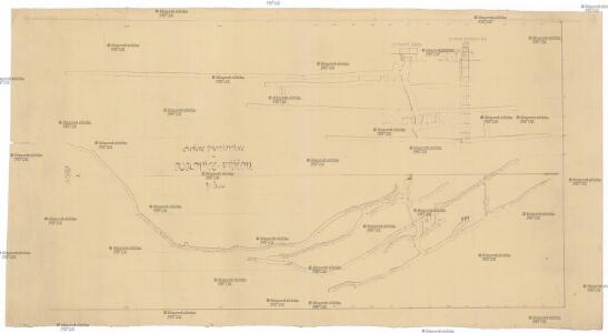
Amine d'antimoine a Dublovice-Přičov
1 : 500 Dublovice (Česko)
[Antimonové doly Dublovice]
Dublovice (Česko)
[Antimonové doly Příčovy]
Příčovy (Česko)
Prziczow (Přičow) - c6235-1-001 - Kaiserpflichtexemplar der Landkarten des stabilen Katasters
1 : 2880
Prziczow (Přičow) - c6235-1-002 - Kaiserpflichtexemplar der Landkarten des stabilen Katasters
1 : 2880
Lhotta Brzekowa - c0551-1-002 - Kaiserpflichtexemplar der Landkarten des stabilen Katasters
1 : 2880
Lhotta Brzekowa - c0551-1-001 - Kaiserpflichtexemplar der Landkarten des stabilen Katasters
1 : 2880
Antimonbergbau Dublovic-Přičov
Dublovice (Česko)
Dublowitz (Dublowic) - c1597-1-005 - Kaiserpflichtexemplar der Landkarten des stabilen Katasters
1 : 2880
Dublowitz (Dublowic) - c1597-1-003 - Kaiserpflichtexemplar der Landkarten des stabilen Katasters
1 : 2880
Dublowitz (Dublowic) - c1597-1-001 - Kaiserpflichtexemplar der Landkarten des stabilen Katasters
1 : 2880
Dublowitz (Dublowic) - c1597-1-002 - Kaiserpflichtexemplar der Landkarten des stabilen Katasters
1 : 2880
Dublowitz (Dublowic) - c1597-1-004 - Kaiserpflichtexemplar der Landkarten des stabilen Katasters
1 : 2880
Solopisk - c7143-1-003 - Kaiserpflichtexemplar der Landkarten des stabilen Katasters
1 : 2880
Solopisk - c7143-1-001 - Kaiserpflichtexemplar der Landkarten des stabilen Katasters
1 : 2880
Solopisk - c7143-1-002 - Kaiserpflichtexemplar der Landkarten des stabilen Katasters
1 : 2880
III. vojenské mapování 4153/1
1 : 25000
Gradkartenblatt
1 : 25000 Sedlčany-oblast (Česko) Gravisi, Karl von

Přehledná mapa vltavské trati Kamýk-Štěchovice
1 : 25000 Kamýk (Česko : vodní nádrž) Ředitelství pro stavbu vodních cest
Wotický vikariát
Votice-oblast (Česko)
III. vojenské mapování 4153
1 : 75000
Sedlčany
1 : 75000 Sedlčany (Česko : oblast) Vojenský zeměpisný ústav
Sedlčany
1 : 75000 Sedlčany (Česko : oblast) Vojenský zeměpisný ústav
Selčan und Jung-Woschitz
1 : 75000 Mladá Vožice (Česko : oblast) Hertel, A. K. u. k. Militärgeographisches Institut
Selčan und Jung-Woschitz
1 : 75000 Mladá Vožice (Česko : oblast) K. u. k. Militärgeographisches Institut
Příbramer Vicariat
Příbram-oblast (Česko)
Vilímkovy místopisné mapy zemí Koruny české
1 : 100000 Benešov (Česko : oblast) Srp, Jan Jos. R. Vilímek
Podrobná mapa Království českého
1 : 100000 Benešov (Česko : oblast) Srp, Jan Jaroslav Bursík