Maps of Neuměřice
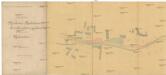
Secundärbahn von Minkovic n. Zvoleňoves Grundeinlösungsplan der Gemeinde Nouměřic
1 : 1000 Minice (Kralupy nad Vltavou, Česko)
Neaumeřitz - c5087-1-003 - Kaiserpflichtexemplar der Landkarten des stabilen Katasters
1 : 2880
Neaumeřitz - c5087-1-002 - Kaiserpflichtexemplar der Landkarten des stabilen Katasters
1 : 2880
Neaumeřitz - c5087-1-004 - Kaiserpflichtexemplar der Landkarten des stabilen Katasters
1 : 2880
Neaumeřitz - c5087-1-001 - Kaiserpflichtexemplar der Landkarten des stabilen Katasters
1 : 2880
Kamenomost (Kamenymost) - c3024-1-001 - Kaiserpflichtexemplar der Landkarten des stabilen Katasters
1 : 2880
Kamenomost (Kamenymost) - c3024-1-002 - Kaiserpflichtexemplar der Landkarten des stabilen Katasters
1 : 2880
Podružná dráha z Minkovic do Zvoleňovse
1 : 1000 Kamenný Most (Česko)
Wollowitz (Wolowic) - c5456-1-001 - Kaiserpflichtexemplar der Landkarten des stabilen Katasters
1 : 2880
Wollowitz (Wolowic) - c5456-1-004 - Kaiserpflichtexemplar der Landkarten des stabilen Katasters
1 : 2880
Wollowitz (Wolowic) - c5456-1-003 - Kaiserpflichtexemplar der Landkarten des stabilen Katasters
1 : 2880
Wollowitz (Wolowic) - c5456-1-002 - Kaiserpflichtexemplar der Landkarten des stabilen Katasters
1 : 2880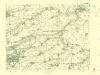
III. vojenské mapování 3952/2
1 : 25000
III. vojenské mapování 3952/2
1 : 25000
Karte des Welwarner Bezirkes im Prager Kreise
1 : 72400 Velvary-oblast (Česko) Wagner, Jan Eduard Karl André
Karte des Welwarner Bezirkes im Prager Kreise
1 : 72400 Velvary-oblast (Česko) Wagner, Jan Eduard Karl André


Podrobné mapy zemí Koruny české v měřítku 1:75.000 a mapa vzdáleností všech míst při silnici ležících - Velvary - Slaný - Kralupy. Průvodce statisticko-historický po všech místech na těchto mapách uvedených a rejstřík věcný názvů hor, potoků, řek, rybníků atd/ Sešit 12. List 40,
1 : 75000
Podrobné mapy zemí Koruny české v měřítku 1:75.000 a mapa vzdáleností všech míst při silnici ležících
1 : 75000 Kralupy nad Vltavou-oblast (Česko) Bělohlav, Josef Kučera, Karel F. Topič
[Náčrt původní Buštěhradské dráhy]
Buštěhradská dráha (Česko : zaniklá železniční trať)
Kladno
1 : 75000 Kladno-oblast (Česko) Vojenský zeměpisný ústav
Soubor přehledných map pro plánování a statistiku: 3952 – Kladno

Soubor přehledných map pro plánování a statistiku: 3952 – Kladno

Slanský vikariát
Slaný-oblast (Česko)
III. vojenské mapování 3952
1 : 75000
Kladno
1 : 75000 Kladno (Česko : oblast) Vojenský zeměpisný ústav
Karte des Gemeindegrenzen

Podrobná mapa okolí Pražského
1 : 75000 Kladno (Česko : oblast) Hevera, Čeněk Obec pražská


