Maps of Transdanubia

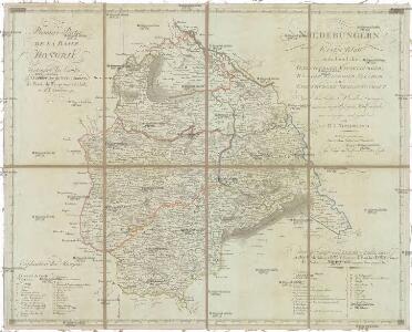
Niederungern
Maďarsko západní Kipferling, Karl Joseph Berken von Ottendorff, Johann im Verlage des Kunst- und Industrie Comptoirs
Niederungern
Maďarsko západní Kipferling, Karl Joseph Berken von Ottendorff, Johann im Verlage des Kunst- und Industrie Comptoirs
Wien, Graz, Budapest
1 : 750000 Budapešť (Maďarsko : oblast) Karl, Ed. K. u. k. Militärgeographisches Institut
Wien, Graz, Budapest
1 : 750000 Budapešť (Maďarsko : oblast) K.u.k. militär-geographisches Institut
Wien, Graz, Budapest
1 : 750000 Budapešť (Maďarsko : oblast) K. u. k. militär-geographisches Institut
Übersichtskarte von Mittel - Europa

[Wien-Ofen].
1 : 576000 Rakousko Blumtritt, H. Oesfeld, C. W.
A németek településterülete a szomszédsági mutató alapján Nyugat-Magyarországon 1980-ban
Ungarn, Transdanubien, Deutsche, Siedlung Bottlik, Zsolt
VIII, uit: General-Karte des oesterreichischen Kaiserstaates mit einem grossen Theile der angrenzenden Länder / durch Josef Scheda ... bearb. und hrsg
1 : 576000 Annotatie geografische gegevens: Maatstokken: oesterreichische Meilen, geografische oder deutsche Meilen, preussische Meilen, türkische Berri, französische Lieues, russische Werste; Maatstok per blad: wiener Klafter, öster. Meilen; Blad XIX: statistische en taalkundige informatie; Blad XIX: legenda [Wien : K.K. Militärisch-Geografisches Institut]
[Rakousko-slovensko-maďarské pomezí].
Burgenland (Rakousko) Kipferling, Karl Joseph Walch, Johann
A németek településterülete a szomszédsági mutató alapján Nyugat-Magyarországon 1880-ban
Ungarn, Transdanubien, Deutsche, Siedlung Bottlik, Zsolt
A németek településterülete a szomszédsági mutató alapján Nyugat-Magyarországon 1941-ban
Ungarn, Transdanubien, Deutsche, Siedlung Bottlik, Zsolt
Bez titulu: Přehledná mapa střední Evropy

A horvátok aránya és száma Nyugat-Magyarországon 1880-ban
Transdanubien Kroaten, Siedlung Bottlik, Zsolt
Generalkarte vom Burgenland
1 : 200000 Burgenland (Rakousko) R. Lechner
A horvátok aránya és száma Nyugat-Magyarországon 1941-ben
Transdanubien Kroaten, Siedlung Bottlik, Zsolt
Kroaten in West-Ungarn 1980
Transdanubien Kroaten, Siedlung Bottlik, Zsolt
A horvátok aránya és száma Nyugat-Magyarországon 1980-ban
Transdanubien Kroaten, Siedlung Bottlik, Zsolt
Kroaten in West-Ungarn 1880
Transdanubien Kroaten, Siedlung Bottlik, Zsolt
Mappa Comitatvs Soproniensis 1758
1 : 1250000 Mollova mapová sbírka Zeller, Sebastian
Kroaten in West-Ungarn 1941
Transdanubien Kroaten, Siedlung Bottlik, Zsolt
Siedlungsgebiet der Deutschen nach dem Nachbarschaftsindex für Westungarn 1880
Ungarn, Transdanubien, Deutsche, Siedlung Bottlik, Zsolt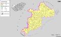
Siedlungsgebiet der Deutschen nach dem Nachbarschaftsindex für Westungarn 1980
Ungarn, Transdanubien, Deutsche, Siedlung Bottlik, Zsolt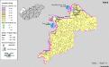
Siedlungsgebiet der Deutschen nach dem Nachbarschaftsindex für Westungarn 1941
Ungarn, Transdanubien, Deutsche, Siedlung Bottlik, Zsolt
Sbírka map a diagramů použitých na mírových konferencích v Paříži v letech 1919 - 1920

Mappa geographica almae dioecesis Weszprimiensis per inclytos comitatus Weszprim, Simigh et Zala
1 : 240000 Veszprém-oblast (Maďarsko) Vizer, Stephan Kopácsy, Joseph
Comitatus Castri Ferrei
1 : 110000 Maďarsko Kenedics, Joseph Mansfeld, Johann Ernst
Vas vármegye
1 : 450000 Kenedics, József Görög, Demeter Görög