Maps of Carpathian Mountains

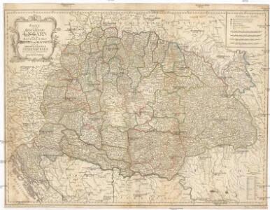
Karte von dem Königreiche Ungarn mit den Königreichen Kroatien und Sklavonien und dem Grossfürstenthum Siebenbürgen
1 : 1390000 Chorvatsko Reilly, Franz Johann Josef von Amon, Anton Franz Joh. Jos. von Reilly
Das Königr. Ungarn mit seinen Nebenländern
Maďarsko Benecke Bormann, E. Ignaz Fuchs
Die kaiserlich oesterreichischen ungarischen Erbstaaten, das ist Ungarn, Siebenbürgen, Dalmatien und die Militair-Graenze
1 : 1522000 Dalmácie (Chorvatsko) Weiland, Karl Ferdinand im Verlage des Geographischen Instituts
Kaiserlich Oesterreichischen Ungarischen Erbstaaten
1 : 1500000 Dalmácie (Chorvatsko) Weiland, Karl Ferdinand Geographischen Instituts
Magyarország és Bosznia automobillal jarható útainak átnézeti térképe
1 : 900000 Bosna Benkö Gyula
A Magyar korona országanaik közigazgatási térképe
1 : 900000 Evropa jihovýchodní Kogutowicz, Manó Magyar Földrajzi Intézet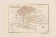
Sbírka map a diagramů použitých na mírových konferencích v Paříži v letech 1919 - 1920
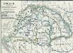
Ungarn zur Zeit der Türkenherrschaft
1 : 7400000 Ungarn, Osmanisches Reich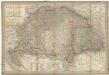
Magyar-Ország
1 : 1400000 Evropa jihovýchodní Fried, Franz List, Joseph Artaria &. Comp.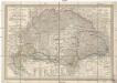
Magyar-Ország
Maďarsko Fried, Franz List, Joseph Artaria &. Comp.
Hvngaria Hodierni Temporis In Partes II et Circulos IV divisa
1 : 4300000 Mollova mapová sbírka
A Magyar szt. korona országai
1 : 2500000 Evropa východní Hölzel Ede
Magyar-Ország : General-, Post- und Strassen-Karte des Königreichs Ungarn und des Grossfürstenthums Siebenbürgen / gezeichnet von F. Fried ; gestochen von J. List
1 : 127500 Annotatie: Met administratieve indeling Fried, F.; List, J. Wien : Artaria
Ungarn 1848, 1849
1 : 7400000 Ungarn Ungarn / Revolution <1848-1849>
Tabula generalis regni Hungariae, Croatiae et Slavoniae nec non magni principatus Tranylvaniae
1 : 1400000 Chorvatsko Lipský, Ján Festetis, Georgio
Tabula generalis regni Hungariae, Croatiae et Slavoniae, nec non magni principatus Transylvaniae
1 : 1400000 Chorvatsko Lipský, Ján Festetis de Tolna, Georgio
M. Moraviae Pars per Hvnniam Occidentalem extensa
1 : 3100000 Mollova mapová sbírka
Die kaiserlich oesterreichischen ungarischen Erbstaaten
1 : 1522000 Dalmácie (Chorvatsko) Weiland, Karl Ferdinand im Verlage des Geographischen Instituts
Die kaiserlich oesterreichischen ungarischen Erbstaaten
1 : 1522000 Dalmácie (Chorvatsko) Weiland, Karl Ferdinand im Verlage des Geographischen Instituts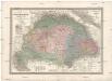
Die kaiserlich oesterreichischen ungarischen Erbstaaten
1 : 1522000 Dalmácie (Chorvatsko) Weiland, Karl Ferdinand im Verlage des Geographischen Instituts
Die Bezirke der Tendenz "A" vor 1875
Ungarn Wahlbezirk, Wahlverhalten
Allgemeine Postkarte von Ungarn Kroatien, Sklavonien und Siebenbürgen zur Uebersicht
Chorvatsko Benedict, Anton im von Reillyschen Landkarten und Kunstwerke Verschleiss Komptoir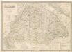
Die Kaiserlich Oesterreichischen Ungarischen Erbstaaten
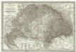
General - Post- und Strassen- Karte des Königreichs Ungarn und des Grossfürstenthums Siebenbürgen
1 : 1400000 Maďarsko Fried, Franz List, Joseph Artaria
Charte von Ungarn, Siebenbürgen u. s. f / nach den bewährtesten Hülfsmitteln neu entworfen und ge
1 : 1600000 1 Karte : Kupferdruck ; 42 x 60 cm Götze, Ferdinand Verlag des Geogr. Instituts
Mappa novissima regnorum Hungariae, Croatiae, Sclavoniae nec non magni principatus Transylvaniae
1 : 700000 Maďarsko Müller, F. Artaria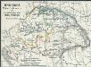
Ungarn's Bisthümer seit den Änderungen unter Maria Theresia
1 : 7400000 Ungarn Maria Theresia, Österreich, Erzherzogin
Carte particuliere de la Hongrie de la Transilvanie de la Croatie et de la Sclavonie

A new map of Hungary, withits divisions into Gespanchafts or Counties,...