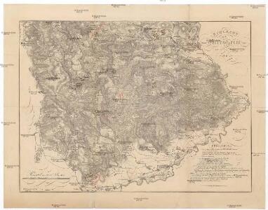
Maps of Landkreis Dillingen an der Donau

Schlacht bey Neresheim am 11.ten August 1796
1 : 170000
Geographica Provinciarum Sveviae Descriptio =
Mollova mapová sbírka Hurter, Johann Christoph Bodenehr, Gabriel
Nordlingen mit der Gegend
Mollova mapová sbírka Bodenehr, Gabriel Bodenehr, Gabriel
Nordlingen mit der Gegend.
1 : 140000 Mollova mapová sbírka Bodenehr, Gabriel Bodenehr, Gabriel
A plan of the famous victory at Bleinem obtained by His Grace the Duke of Malborough over the Elector of Bavaria and the Marechals Tallard and Marcin, the 13th August, 1704 S.N
1 : 20000 J. van Vianen fecit [Amsterdam] : Reynerus Leers excudit
Plan of the glorious Battle of Hochstet
Plan of the glorious Battle of Hochstet [or Blenheim]. ... For Tindal's Continuation of Rapin's History of England. [London]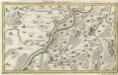
Lauingen und Confinen
1 : 140000 Mollova mapová sbírka Bodenehr, Gabriel Bodenehr, Gabriel
La Battaille de Hoechstedt
1 : 50000 Mollova mapová sbírka Husson, Pieter Husson, Pierre
Meßtischblatt [7327] : Giengen, 1931
1 : 250000 Giengen. - 1:25000. - Stuttgart, 1931. - 1 Kt.
Meßtischblatt [7227] : Elchingen, 1930
1 : 250000 Elchingen. - 1:25000. - Stuttgart, 1930. - 1 Kt.
Tractus Nordlingensis Germ. Ries dicti accurata Descriptio adjecto Indice, cui Dominium cujusvis loci aliaque Iura competant illustrata
1 : 50000 Mollova mapová sbírka Homann, Johann Baptist Homann, Johann Baptista - dědici
Plan allwo die blutige u. fatale Rencontre, zwischen denen fürstl. Ötting. u. Grälich Watterstein. und dann zwischen denen Nördlingern andern theils Vorberg gegangen so geschehen d. 19. Aug. 1726
Mollova mapová sbírka
Unter allen Schlachten dieses Seculi hat die Höchste Stadt die Schlacht bey Höchstädt geschehen den 13. Aug. 1704

Meßtischblatt 63 = [7127] : Lauchheim, 1935
1 : 250000 Lauchheim. - 1:25000. - Stuttgart, 1935. - 1 Kt.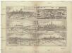
Monacvm, nominatissima Bavariae civitas
Freising (Německo) Braun, Georg Hogenberg, Franz
Meßtischblatt [7326] : Heidenheim, 1928
1 : 250000 Heidenheim. - 1:25000. - Stuttgart, 1928. - 1 Kt.
Meßtischblatt [7226] : Oberkochen, 1927
1 : 250000 Oberkochen. - 1:25000. - Stuttgart, 1927. - 1 Kt.
Geographica Provinciarum Sveviae Descriptio =
Mollova mapová sbírka Hurter, Johann Christoph Bodenehr, Johann Georg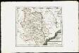
Die Grafschaft Oetingen mit den freyen Reichsstädten Nördlingen Bopfingen und Dünkelsbühl : Nro. 181
Reilly, Franz Johann Joseph von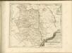

Mappa geographica comitatvs Oettingensis in circulo Sueviceo siti
1 : 100000 Švábsko (Německo) Cnopf, Matthäus Ferdinand edentibus Homanninanis Heredibus
Mappa Geographica Comitatvs Oettingensis
1 : 100000 Mollova mapová sbírka Cnopf, Matthäus Ferdinand Homann, Johann Baptista - dědici
Suevia Universa :
1 : 170000 Mollova mapová sbírka Michal, Jacques de Seutter, Matthäus Seutter, Matthäus
Neueste Karte von der Markgrafschaft Burgau zu den oesterreichischen Vorlanden in Schwaben gehörig
1 Karte : Kupferdruck ; 54 x 47 cm Probst; Sprengler Johann Michael Probst
172. Nördlingen, uit: Topographische Uebersichtskarte des Deutschen Reiches / herausgegeben v. d. Kartogr. Abt. d. Königl. Preuß. Landesaufnahme
1 : 200000 titelvariant: Topogr. Übersichtskarte des Deutschen Reiches; Annotatie: Titel boven bladen ook: Topogr. Übersichtskarte des Deutschen Reiches; Annotatie geografische gegevens: Op elk blad twee maatstokken: 10 Kilometer = 5,5 cm; 1 geogr. Meile = 3,6 cm; Legenda onder op elk blad Königlich Preußische Landesaufnahme. Kartographische Abtheilung [S.l : Königlich Preußische Landesaufnahme, Kartographische Abtheilung]
Nieuwe Kaart, van t'Land Donawert, en Hochstett &c.
1 : 200000 Mollova mapová sbírka Visscher, Nicolaes Jansz. Visscher, Nicolaus II.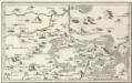
Aalen, Albuch a okolí]
Mollova mapová sbírka Bodenehr, Gabriel Bodenehr, Gabriel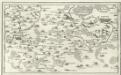
Geislingen, Heydenheim, Gienden a okolí]
Mollova mapová sbírka Bodenehr, Gabriel Bodenehr, Gabriel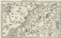
Lauingen und Confinen
Mollova mapová sbírka Bodenehr, Gabriel Bodenehr, Gabriel