Maps of Kruishoutem

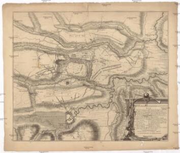
Plan de la bataille d'Oudenaerde du jj juillet 1708
1 : 2400 Mosburger, G. L. Doesborgh, Thomas par Doesburgh
Plan parcellaire de la commune de Cruyshautem : avec les mutations
1 : 5000 Royal Library of Belgium Map Room Popp, Philippe Christian (1805-1879) Popp, Philippe Christian (1805-1879)
Plan parcellaire de la commune de Huysse : avec les mutations
1 : 5000 Royal Library of Belgium Map Room Popp, Philippe Christian (1805-1879) Popp, Philippe Christian (1805-1879)
Plan parcellaire de la commune de Worteghem : avec les mutations
1 : 5000 Royal Library of Belgium Map Room Popp, Philippe Christian (1805-1879) Popp, Philippe Christian (1805-1879)
Plan parcellaire de la commune de Eyne : avec les mutations
1 : 5000 Royal Library of Belgium Map Room Popp, Philippe Christian (1805-1879) Popp, Philippe Christian (1805-1879)
Plan parcellaire de la commune de Nokere : avec les mutations
1 : 5000 Royal Library of Belgium Map Room Popp, Philippe Christian (1805-1879) Popp, Philippe Christian (1805-1879)
Plan parcellaire de la commune de Wannegem-Lede : avec les mutations
1 : 5000 Royal Library of Belgium Map Room Popp, Philippe Christian (1805-1879) Popp, Philippe Christian (1805-1879)
Plan parcellaire de la commune de Mullem : avec les mutations
1 : 5000 Royal Library of Belgium Map Room Popp, Philippe Christian (1805-1879) Popp, Philippe Christian (1805-1879)
Plan de la bataille d'Oudenaerde du 11 Juillet 1708
1 : 30000 Belgie K.k. Generalstabes
Plan parcellaire de la commune de Mooregem : avec les mutations
1 : 5000 Royal Library of Belgium Map Room Popp, Philippe Christian (1805-1879) Popp, Philippe Christian (1805-1879)
Plan parcellaire de la commune de Oycke : avec les mutations
1 : 5000 Royal Library of Belgium Map Room Popp, Philippe Christian (1805-1879) Popp, Philippe Christian (1805-1879)
Plan parcellaire de la commune de Heurne : avec les mutations
1 : 2500 Royal Library of Belgium Map Room Popp, Philippe Christian (1805-1879) Popp, Philippe Christian (1805-1879)
Plan parcellaire de la commune de Bevere Lez-Audenarde : avec les mutations
1 : 5000 Royal Library of Belgium Map Room Popp, Philippe Christian (1805-1879) Popp, Philippe Christian (1805-1879)
Plan parcellaire de la commune de Auweghem : avec les mutations
1 : 5000 Royal Library of Belgium Map Room Popp, Philippe Christian (1805-1879) Popp, Philippe Christian (1805-1879)
Plan parcellaire de la commune de Synghem : avec les mutations
1 : 5000 Royal Library of Belgium Map Room Popp, Philippe Christian (1805-1879) Popp, Philippe Christian (1805-1879)
Plan parcellaire de la commune de Welden : avec les mutations
1 : 5000 Royal Library of Belgium Map Room Popp, Philippe Christian (1805-1879) Popp, Philippe Christian (1805-1879)
Plan parcellaire de la commune de Neder-Eename : avec les mutations
1 : 2500 Royal Library of Belgium Map Room Popp, Philippe Christian (1805-1879) Popp, Philippe Christian (1805-1879)
Plan parcellaire de la commune de Eename : avec les mutations
1 : 2500 Royal Library of Belgium Map Room Popp, Philippe Christian (1805-1879) Popp, Philippe Christian (1805-1879)
Plan du Champ de Bataille, prés d'Oudenaerde l'11. Juillet 1708
1 : 30000 Mollova mapová sbírka Husson, Pieter Schouten, G. Husson, Pierre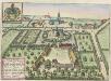
MVLLEM : [bird's-eye view]
[Amsterdam : Joan Blaeu]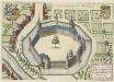
CASTELLVM DE PAMELE : [bird's-eye view]
[Amsterdam : Joan Blaeu]
ALDENARDA vulgo AVDENAERDE : [plan and view]
[Amsterdam : Joan Blaeu]
Plan parcellaire de la commune de Volkegem : avec les mutations
1 : 5000 Royal Library of Belgium Map Room Popp, Philippe Christian (1805-1879) Popp, Philippe Christian (1805-1879)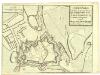
Oudenarde, ville forte du comte de Flandre

Plan parcellaire de la commune de Edelaere : avec les mutations
1 : 2500 Royal Library of Belgium Map Room Popp, Philippe Christian (1805-1879) Popp, Philippe Christian (1805-1879)
Plan du champ de bataille, prés d'Oudenaerde l'11. Juillet 1708
1 : 30000 G. Schouten f.
Plan parcellaire de la commune de Asper : avec les mutations
1 : 5000 Royal Library of Belgium Map Room Popp, Philippe Christian (1805-1879) Popp, Philippe Christian (1805-1879)
Plan parcellaire de la commune de Peteghem : avec les mutations
1 : 5000 Royal Library of Belgium Map Room Popp, Philippe Christian (1805-1879) Popp, Philippe Christian (1805-1879)
Plan parcellaire de la commune de Maeter : avec les mutations
1 : 5000 Royal Library of Belgium Map Room Popp, Philippe Christian (1805-1879) Popp, Philippe Christian (1805-1879)