Maps of Czech Republic

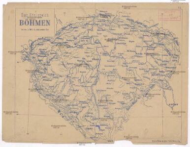
Das Königreich Böhmen
Čechy (Česko) Benecke Bormann, E. Ignaz Fuchs
[Čechy]
Česko
[Čechy]
Česko
Cesty ptáků zemních v Čechách
Čechy (Česko) Šír, Vladislav
Cesty ptáků bahních a vodních v Čechách
Čechy (Česko) Schier, Vladislav
Království české podle nejnovějšího rozdělení na 7 krajů a s poznamenáním sídel okresních hejtmanství a soudů
1 : 800000 Čechy (Česko) Krečmar, Bedřich
Postcours-Karte von Böhmen
Praha (Česko) R. v. Waldheim
Národnostní mapa Království Českého na základě sčítání lidu z roku 1880

Karte über die Schafwollwaren...

Karte des Koenigreichs Boehmen

G. Freytag's Landtags-Wahlkarte von Böhmen 1901
1 : 1000000 Česko Freytag, Gustav G. Freytag & Berndt
Volební mapa do říšského sněmu
1 : 1000000 Česko G. Freytag & Berndt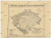
Rozdělení Království českého
Česko Ludvík Bratršovský
Bez titulu: Soubor statistických map Čech

Karte vom Königreiche Böhmen in Cameralämtlicher Hinsicht
Praha (Česko) Seidler, Karl Friedrich
Čechy
Česko Gräf, C. Langhans, J.
Königreich Böhmen
Česko Tachauer, Ludwig Langhans, J.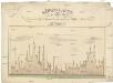
Höhen-Karte, oder, Vergleichende Tafel der barometrischgemessenen Berg- und Städte-Höhen Boehmens
Česko Dlask, Vavřinec Vojtěch Langweil, Antonín Schönfeldische Steindruckerey
Karte des landtäflichen Grossgrund - Besitzes im Königreiche... Böhmen
Mapa rozšíření rašelin v Čechách
1 : 2660000 Čechy (Česko) Sitenský, František Ladislav Kořistka, Karel František Edvard A. Haase
Neueste General Post & Strassen Karte des Königreichs Boehmen

Karte des Koenigreichs Boehmen
1 : 400000 Čechy (Česko) Loth, Johann Anděl, Bedřich Verlag von Friedrich Kretzschmar
Generální mappa království Českého

Historische Karte vom Königreich Böhmen
Čechy (Česko) Pařízek, Aleš Vincenc Niederhofer, Ondřej
Historische Karte vom Königreich Böhmen
Česko Pařízek, Aleš Vincenc Niederhofer, Ondřej
Přehledná mapa železniční království Českého

General-Karte des Königreiches Böhmen
1 : 378000 Čechy (Česko) Kořistka, Karel František Edvard Sommer, Adolf Eduard Hölzel's Verlag
Geologische Karte von Böhmen

Strassen-Uibersichts- und Militair-Routen-Karte des Königreichs Böhmen
1 : 580400 Česko Berra, Marco Marco Berra
Strassen-Uibersichts- und Militair-Routen-Karte des Königreichs Böhmen
1 : 580400 Česko Berra, Marco Marco Berra
Strassen-Uibersichts- und Militair-Routen-Karte des Königreichs Böhmen
1 : 580400 Česko Windisch-Graetz, Alfred Kandidus Joh. Evang. G. Sandtner
Strassen-Uibersichts- und Militair-Routen-Karte des Königreichs Böhmen
1 : 580400 Česko Berra, Marco Marco Berra