Maps of Westminster

Insurance Plan of London Vol. IX: sheet 233
1 : 480 This detailed 1889 plan of London is one of a series of twenty-seven sheets in an atlas originally produced to aid insurance companies in assessing fire risks. The building footprints, their use (commercial, residential, educational, etc.), the number of floors and the height of the building, as well as construction materials (and thus risk of burning) and special fire hazards (chemicals, kilns, ovens) were documented in order to estimate premiums. Names of individual businesses, property lines, and addresses were also often recorded. Together these maps provide a rich historical shapshot of the commercial activity and urban landscape of towns and cities at the time. The British Library holds a comprehensive collection of fire insurance plans produced by the London-based firm Charles E. Goad Ltd. dating back to 1885. These plans were made for most important towns and cities of the British Isles at the scales of 1:480 (1 inch to 40 feet), as well as many foreign towns at 1:600 (1 inch to 50 feet). Chas E Goad Limited Chas E Goad Limited
Insurance Plan of London Vol. IX: sheet 232
1 : 480 This detailed 1889 plan of London is one of a series of twenty-seven sheets in an atlas originally produced to aid insurance companies in assessing fire risks. The building footprints, their use (commercial, residential, educational, etc.), the number of floors and the height of the building, as well as construction materials (and thus risk of burning) and special fire hazards (chemicals, kilns, ovens) were documented in order to estimate premiums. Names of individual businesses, property lines, and addresses were also often recorded. Together these maps provide a rich historical shapshot of the commercial activity and urban landscape of towns and cities at the time. The British Library holds a comprehensive collection of fire insurance plans produced by the London-based firm Charles E. Goad Ltd. dating back to 1885. These plans were made for most important towns and cities of the British Isles at the scales of 1:480 (1 inch to 40 feet), as well as many foreign towns at 1:600 (1 inch to 50 feet). Chas E Goad Limited Chas E Goad Limited
Insurance Plan of London Vol. VIII: sheet 198
1 : 480 This detailed 1888 plan of London is one of a series of twenty-six sheets in an atlas originally produced to aid insurance companies in assessing fire risks. The building footprints, their use (commercial, residential, educational, etc.), the number of floors and the height of the building, as well as construction materials (and thus risk of burning) and special fire hazards (chemicals, kilns, ovens) were documented in order to estimate premiums. Names of individual businesses, property lines, and addresses were also often recorded. Together these maps provide a rich historical shapshot of the commercial activity and urban landscape of towns and cities at the time. The British Library holds a comprehensive collection of fire insurance plans produced by the London-based firm Charles E. Goad Ltd. dating back to 1885. These plans were made for most important towns and cities of the British Isles at the scales of 1:480 (1 inch to 40 feet), as well as many foreign towns at 1:600 (1 inch to 50 feet). Chas E Goad Limited Chas E Goad Limited
Insurance Plan of London Vol. VIII: sheet 199
1 : 480 This detailed 1888 plan of London is one of a series of twenty-six sheets in an atlas originally produced to aid insurance companies in assessing fire risks. The building footprints, their use (commercial, residential, educational, etc.), the number of floors and the height of the building, as well as construction materials (and thus risk of burning) and special fire hazards (chemicals, kilns, ovens) were documented in order to estimate premiums. Names of individual businesses, property lines, and addresses were also often recorded. Together these maps provide a rich historical shapshot of the commercial activity and urban landscape of towns and cities at the time. The British Library holds a comprehensive collection of fire insurance plans produced by the London-based firm Charles E. Goad Ltd. dating back to 1885. These plans were made for most important towns and cities of the British Isles at the scales of 1:480 (1 inch to 40 feet), as well as many foreign towns at 1:600 (1 inch to 50 feet). Chas E Goad Limited Chas E Goad Limited
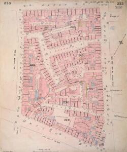
Insurance Plan of London Vol. IX: sheet 225
1 : 480 This detailed 1889 plan of London is one of a series of twenty-seven sheets in an atlas originally produced to aid insurance companies in assessing fire risks. The building footprints, their use (commercial, residential, educational, etc.), the number of floors and the height of the building, as well as construction materials (and thus risk of burning) and special fire hazards (chemicals, kilns, ovens) were documented in order to estimate premiums. Names of individual businesses, property lines, and addresses were also often recorded. Together these maps provide a rich historical shapshot of the commercial activity and urban landscape of towns and cities at the time. The British Library holds a comprehensive collection of fire insurance plans produced by the London-based firm Charles E. Goad Ltd. dating back to 1885. These plans were made for most important towns and cities of the British Isles at the scales of 1:480 (1 inch to 40 feet), as well as many foreign towns at 1:600 (1 inch to 50 feet). Chas E Goad Limited Chas E Goad Limited
A MAP OF THE South Western District OF Saint Pancras Parish
1 : 1800 The title of this plan of St. Pancras Parish appears at lower left with the publisher's imprint and scale bar. Buildings, roads, squares and open spaces are depicted in various colours. A note below the title states that the plan was reduced for the Commissioners of Paving, Lighting, Watching, Watering etc. from a large plan in their possession. Farey, William
A plan of the City's Estate in Tottenham Court Road
This plan shows a proposed new street near Bedford Square on land owned by the City of London.In the notes on the left side of the sheet the rationale behind the different colours is explained.Gentlemen's houses are to be built with gardens, at the opposite end of which will be houses for shopkeepers.The shops will have large fronts opening on to Tottenham Court Road.The rear wall of the shop keepers houses are to have no lights or other openings, presumably so as not to overlook the gardens of the gentlemen. Metcalf, R.
A Plan of the intended improvements from Charing Cross to Bedford Square
A plan of intended improvements from Charing Cross to Bedford Square. Sawyer, Henry
General Plan, shewing the whole line of the Proposed New Street to the British Museum
1 : 4800 A plan of the proposed street running to the British Museum in Bloomsbury. Ingrey & Madeley's
PLAN of the late Duke of PORTLAND'S Estate in the neighborhood of SOHO SQUARE - with the names (in red ink) of the Persons to whom the several parts were sold
1 : 900 The title and scale bar of this copy of White's plan appears at the foot of the plate. On the Duke's death, the estate was divided into individual properties and the names of the new landlords are indicated on the plan in red ink. White, John
Frontage plan in the parish of St. James, Westminster. From Report on an Enquiry and Examination into the State of the Drainage of the House situated in that part of the Parish of St. James, Westminster, in which deaths have occurred from Cholera to so great an extent.
London VII.53 - OS London Town Plan
1 : 1056 Topographic maps Ordnance Survey Ordnance Survey
Insurance Plan of London Vol. IX: sheet 224
1 : 480 This detailed 1889 plan of London is one of a series of twenty-seven sheets in an atlas originally produced to aid insurance companies in assessing fire risks. The building footprints, their use (commercial, residential, educational, etc.), the number of floors and the height of the building, as well as construction materials (and thus risk of burning) and special fire hazards (chemicals, kilns, ovens) were documented in order to estimate premiums. Names of individual businesses, property lines, and addresses were also often recorded. Together these maps provide a rich historical shapshot of the commercial activity and urban landscape of towns and cities at the time. The British Library holds a comprehensive collection of fire insurance plans produced by the London-based firm Charles E. Goad Ltd. dating back to 1885. These plans were made for most important towns and cities of the British Isles at the scales of 1:480 (1 inch to 40 feet), as well as many foreign towns at 1:600 (1 inch to 50 feet). Chas E Goad Limited Chas E Goad Limited
Insurance Plan of London North West District Vol. C: sheet 31-1
1 : 480 This detailed 1900 plan of London is one of a series of thirteen sheets in an atlas originally produced to aid insurance companies in assessing fire risks. The building footprints, their use (commercial, residential, educational, etc.), the number of floors and the height of the building, as well as construction materials (and thus risk of burning) and special fire hazards (chemicals, kilns, ovens) were documented in order to estimate premiums. Names of individual businesses, property lines, and addresses were also often recorded. Together these maps provide a rich historical shapshot of the commercial activity and urban landscape of towns and cities at the time. The British Library holds a comprehensive collection of fire insurance plans produced by the London-based firm Charles E. Goad Ltd. dating back to 1885. These plans were made for most important towns and cities of the British Isles at the scales of 1:480 (1 inch to 40 feet), as well as many foreign towns at 1:600 (1 inch to 50 feet). Chas E Goad Limited Chas E Goad Limited
London &c. actually survey'd by Wm. Morgan
Ogilby, John
To the Most Noble JOHN, DUKE OF BEDFORD. This Plan of the United Parishes of ST. GILES in the FIELDS & ST. GEORGE, BLOOMSBURY, 4
1 : 444 This map is dedicated to the Duke of Bedford as this area was the primary metropolitan estate of the Earls ans Dukes of Bedford. Russell was the family name of the Dukes of Bedford, hence Russell Square. Bedford house, built for the 3rd Earl of Bedford in 1586, lay adjacent to Montague house, later to be the British Museum, until 1705-6 when it was demolished. In the lower left hand corner is a vignette of a statue of a Duke of Bedford. A birds eye view of the British Museum and a view of the College of Surgeons are also included as is a statue of C.J Fox right hon, the orator. Wyld, James
Plan OF THE PARISHES OR DIVISION OF St Giles in the Fields And ST. GEORGE, BLOOMSBURY. 1815 2
1 : 2400 Different pastel colours describe the Parish divisions within St. Giles in the Fields and St. George's, Bloomsbury. A plan of the Burial Ground and Chapel of St. Giles in the Field, adjoining the church yard of St Pancreas, is located in a separate border. Montagu House was sold in 1755 to house the British museum. It was demolished to make way for Smirke''s building in the 1840''s. Hewitt, N.R.
Insurance Plan of London Vol. IX: Key Plan
1 : 480 This "key plan" indicates coverage of the Goad 1889 series of fire insurance maps of London that were originally produced to aid insurance companies in assessing fire risks. The building footprints, their use (commercial, residential, educational, etc.), the number of floors and the height of the building, as well as construction materials (and thus risk of burning) and special fire hazards (chemicals, kilns, ovens) were documented in order to estimate premiums. Names of individual businesses, property lines, and addresses were also often recorded. Together these maps provide a rich historical shapshot of the commercial activity and urban landscape of towns and cities at the time. The British Library holds a comprehensive collection of fire insurance plans produced by the London-based firm Charles E. Goad Ltd. dating back to 1885. These plans were made for most important towns and cities of the British Isles at the scales of 1:480 (1 inch to 40 feet), as well as many foreign towns at 1:600 (1 inch to 50 feet). Chas E Goad Limited Chas E Goad Limited
Insurance Plan of London Vol. VIII: Key Plan
1 : 480 This "key plan" indicates coverage of the Goad 1888 series of fire insurance maps of London that were originally produced to aid insurance companies in assessing fire risks. The building footprints, their use (commercial, residential, educational, etc.), the number of floors and the height of the building, as well as construction materials (and thus risk of burning) and special fire hazards (chemicals, kilns, ovens) were documented in order to estimate premiums. Names of individual businesses, property lines, and addresses were also often recorded. Together these maps provide a rich historical shapshot of the commercial activity and urban landscape of towns and cities at the time. The British Library holds a comprehensive collection of fire insurance plans produced by the London-based firm Charles E. Goad Ltd. dating back to 1885. These plans were made for most important towns and cities of the British Isles at the scales of 1:480 (1 inch to 40 feet), as well as many foreign towns at 1:600 (1 inch to 50 feet). Chas E Goad Limited Chas E Goad Limited
London (1915- Numbered sheets) V.9 (includes: City Of Westminster; St Marylebone; St Pancras) - 25 Inch Map
1 : 2500 Topographic maps Ordnance Survey Ordnance Survey
London (First Editions c1850s) XXXIV (includes: City Of Westminster; St Marylebone; St Pancras) - 25 Inch Map
1 : 2500 Topographic maps Ordnance Survey Ordnance Survey
Plan, presented to the House of Commons, of a street proposed from Charing Cross to Portland Place, leading to the Crown Estate in Mary-le-Bone Park.
Basire, James
PLAN, presented to the House of Commons, of a STREET proposed from Charing Cross to Portland Place, leading to the Crown Estate in Mary-le-Bone Park
1 : 3684 This original design for Regent Street was commissioned by the House of Commons.The title appears along the top, with a descriptive note below the plan and a scale bar at the bottom centre. Crown Property is highlighted in blue.Starting at Carlton House, Regent Street ran through crownland at Piccadilly (where a circus was built) before turning north-west along Swallow Street, in Soho, finally joining Portland Place north of Oxford Street. Basire, James
Collins' Illustrated Atlas of London with 7000 references, in 36 plates of the principal routes between St. Paul's and the suburbs, from a survey made expressly for this work, by R. Jarman

PLAN OF A Street Proposed FROM CHARING CROSS TO PORTLAND PLACE.
1 : 6000 This is Nash's original design for Regent Street.The title appears at top right, with compass star and scale bar at the bottom left. The course of the street highlighted in yellow, with Crown property is highlighted in blue.Starting at Carlton House, Regent Street ran through crownland at Piccadilly (where a circus was built) before turning north-west along Swallow Street, in Soho, finally joining Portland Place north of Oxford Street. Thompson
Insurance Plan of London: General Key Plan of North Side of River
1 : 4800 This "key plan" indicates coverage of the Goad 1889 series of fire insurance maps of London that were originally produced to aid insurance companies in assessing fire risks. The building footprints, their use (commercial, residential, educational, etc.), the number of floors and the height of the building, as well as construction materials (and thus risk of burning) and special fire hazards (chemicals, kilns, ovens) were documented in order to estimate premiums. Names of individual businesses, property lines, and addresses were also often recorded. Together these maps provide a rich historical shapshot of the commercial activity and urban landscape of towns and cities at the time. The British Library holds a comprehensive collection of fire insurance plans produced by the London-based firm Charles E. Goad Ltd. dating back to 1885. These plans were made for most important towns and cities of the British Isles at the scales of 1:480 (1 inch to 40 feet), as well as many foreign towns at 1:600 (1 inch to 50 feet). Chas E Goad Limited Chas E Goad Limited
A PLAN OF HIS MAJESTY'S BAYLIWICK OF ST. JAMES IN THE COUNTY OF MIDDLESEX
1 : 2400 This drawn survey of the West of London extends from Knightsbridge to Temple Bar and from Marylebone Gardens to Buckingham Palace. Buildings are indicated in red, open spaces and park land in green and watercourses in blue. Symbols are used to distinguish land use. Gough, William
Vrbium Londini et West-Monasterii nec non suburbii Southwark accurata ichnographia, 1
1 Blatt : 52 x 64 cm Homännische Erben
A New and Exact Plan of the City of LONDON and Suburbs thereof, With the addition of the New Buildings, Churches &c. to this present Year 1720 (Not extant in any other)
1 : 6336 This map of the West End of London is part of Henry Overton's complete map of London and its suburbs, published in 1720.The title and publisher's imprint appear in cartouche in the centre, with fares of hackney coaches and an overall key at bottom left. The compass rose appears in the river, with parish boundaries outlined in colour. Henry Overton took over his father John's publishing business in 1707 and continued to publish maps from the same address at White Horse near Newgate. Overton, Henry