Maps of Coventry

Insurance Plan of Coventry: sheet 5
1 : 480 This detailed 1897 plan of Coventry is one of a series of eleven sheets in an atlas originally produced to aid insurance companies in assessing fire risks. The building footprints, their use (commercial, residential, educational, etc.), the number of floors and the height of the building, as well as construction materials (and thus risk of burning) and special fire hazards (chemicals, kilns, ovens) were documented in order to estimate premiums. Names of individual businesses, property lines, and addresses were also often recorded. Together these maps provide a rich historical shapshot of the commercial activity and urban landscape of towns and cities at the time. The British Library holds a comprehensive collection of fire insurance plans produced by the London-based firm Charles E. Goad Ltd. dating back to 1885. These plans were made for most important towns and cities of the British Isles at the scales of 1:480 (1 inch to 40 feet), as well as many foreign towns at 1:600 (1 inch to 50 feet). Chas E Goad Limited Chas E Goad Limited
Insurance Plan of Coventry: sheet 3-1
1 : 480 This detailed 1897 plan of Coventry is one of a series of eleven sheets in an atlas originally produced to aid insurance companies in assessing fire risks. The building footprints, their use (commercial, residential, educational, etc.), the number of floors and the height of the building, as well as construction materials (and thus risk of burning) and special fire hazards (chemicals, kilns, ovens) were documented in order to estimate premiums. Names of individual businesses, property lines, and addresses were also often recorded. Together these maps provide a rich historical shapshot of the commercial activity and urban landscape of towns and cities at the time. The British Library holds a comprehensive collection of fire insurance plans produced by the London-based firm Charles E. Goad Ltd. dating back to 1885. These plans were made for most important towns and cities of the British Isles at the scales of 1:480 (1 inch to 40 feet), as well as many foreign towns at 1:600 (1 inch to 50 feet). Chas E Goad Limited Chas E Goad Limited
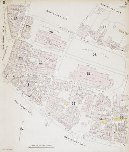
Insurance Plan of Coventry: sheet 11-1
1 : 480 This detailed 1897 plan of Coventry is one of a series of eleven sheets in an atlas originally produced to aid insurance companies in assessing fire risks. The building footprints, their use (commercial, residential, educational, etc.), the number of floors and the height of the building, as well as construction materials (and thus risk of burning) and special fire hazards (chemicals, kilns, ovens) were documented in order to estimate premiums. Names of individual businesses, property lines, and addresses were also often recorded. Together these maps provide a rich historical shapshot of the commercial activity and urban landscape of towns and cities at the time. The British Library holds a comprehensive collection of fire insurance plans produced by the London-based firm Charles E. Goad Ltd. dating back to 1885. These plans were made for most important towns and cities of the British Isles at the scales of 1:480 (1 inch to 40 feet), as well as many foreign towns at 1:600 (1 inch to 50 feet). Chas E Goad Limited Chas E Goad Limited
Insurance Plan of Coventry: sheet 3-2
1 : 480 This detailed 1897 plan of Coventry is one of a series of eleven sheets in an atlas originally produced to aid insurance companies in assessing fire risks. The building footprints, their use (commercial, residential, educational, etc.), the number of floors and the height of the building, as well as construction materials (and thus risk of burning) and special fire hazards (chemicals, kilns, ovens) were documented in order to estimate premiums. Names of individual businesses, property lines, and addresses were also often recorded. Together these maps provide a rich historical shapshot of the commercial activity and urban landscape of towns and cities at the time. The British Library holds a comprehensive collection of fire insurance plans produced by the London-based firm Charles E. Goad Ltd. dating back to 1885. These plans were made for most important towns and cities of the British Isles at the scales of 1:480 (1 inch to 40 feet), as well as many foreign towns at 1:600 (1 inch to 50 feet). Chas E Goad Limited Chas E Goad Limited
Insurance Plan of Coventry: sheet 7
1 : 480 This detailed 1897 plan of Coventry is one of a series of eleven sheets in an atlas originally produced to aid insurance companies in assessing fire risks. The building footprints, their use (commercial, residential, educational, etc.), the number of floors and the height of the building, as well as construction materials (and thus risk of burning) and special fire hazards (chemicals, kilns, ovens) were documented in order to estimate premiums. Names of individual businesses, property lines, and addresses were also often recorded. Together these maps provide a rich historical shapshot of the commercial activity and urban landscape of towns and cities at the time. The British Library holds a comprehensive collection of fire insurance plans produced by the London-based firm Charles E. Goad Ltd. dating back to 1885. These plans were made for most important towns and cities of the British Isles at the scales of 1:480 (1 inch to 40 feet), as well as many foreign towns at 1:600 (1 inch to 50 feet). Chas E Goad Limited Chas E Goad Limited
Warwickshire XXI.12 (includes: Coventry) - 25 Inch Map
1 : 2500 Topographic maps Ordnance Survey Ordnance Survey
Warwickshire XXI.12 (includes: Coventry) - 25 Inch Map
1 : 2500 Topographic maps Ordnance Survey Ordnance Survey
Warwickshire XXI.12 (includes: Coventry) - 25 Inch Map
1 : 2500 Topographic maps Ordnance Survey Ordnance Survey
Insurance Plan of Coventry: Key Plan
1 : 4800 This "key plan" indicates coverage of the Goad 1897 series of fire insurance maps of Coventry that were originally produced to aid insurance companies in assessing fire risks. The building footprints, their use (commercial, residential, educational, etc.), the number of floors and the height of the building, as well as construction materials (and thus risk of burning) and special fire hazards (chemicals, kilns, ovens) were documented in order to estimate premiums. Names of individual businesses, property lines, and addresses were also often recorded. Together these maps provide a rich historical shapshot of the commercial activity and urban landscape of towns and cities at the time. The British Library holds a comprehensive collection of fire insurance plans produced by the London-based firm Charles E. Goad Ltd. dating back to 1885. These plans were made for most important towns and cities of the British Isles at the scales of 1:480 (1 inch to 40 feet), as well as many foreign towns at 1:600 (1 inch to 50 feet). Chas E Goad Limited Chas E Goad Limited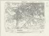
Warwickshire XXI.SE - OS Six-Inch Map
1 : 10560 Topographic maps Ordnance Survey Ordnance Survey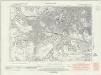
Warwickshire XXI.SE - OS Six-Inch Map
1 : 10560 Topographic maps Ordnance Survey Ordnance Survey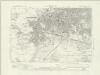
Warwickshire XXI.SE - OS Six-Inch Map
1 : 10560 Topographic maps Ordnance Survey Ordnance Survey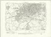
Warwickshire XXI.SE - OS Six-Inch Map
1 : 10560 Topographic maps Ordnance Survey Ordnance Survey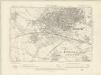
Warwickshire XXI.SE - OS Six-Inch Map
1 : 10560 Topographic maps Ordnance Survey Ordnance Survey
Warwickshire XXI.SE - OS Six-Inch Map
1 : 10560 Topographic maps Ordnance Survey Ordnance Survey
SP37 - OS 1:25,000 Provisional Series Map
1 : 25000 Topographic maps Ordnance Survey Ordnance Survey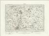
Coventry (Outline) - OS One-Inch Revised New Series
1 : 63360 Topographic maps Ordnance Survey Ordnance Survey
Coventry (Hills) - OS One-Inch Revised New Series
1 : 63360 Topographic maps Ordnance Survey Ordnance Survey
Warwick
1 : 31680 This,plan of,part of South Warwickshire shows the broad valley of the River Avon,to the,left of the sheet with the county town,shown at middle left along the riverbank. Major roads are highlighted in buff and feature tollgates and turnpikes along their routes. Turnpike Trusts were,established between the 17th and 19th centuries to raise money from travellers for the upkeep and maintenance of roads. Stevens, Henry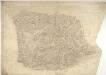
Rugby
1 : 31680 This plan covers part of East Warwickshire showing the Warwick and Oxford Canals at the top the sheet. Nearby is the intersection of two Roman roads: the Fosse Way and Watling Street. Coombe Abbey, depicted in the lower part of the sheet, had been one of the the most powerful and wealthy monasteries in Warwickshire. Following Henry VIII's dissolution of the monasteries, Sir John Harrington bought the abbey and built a new house on the property, incorporating much of the stonework from the disbanded monastery. The Craven family, who owned the property for the 300 years after Harrington's death, constructed the formal gardens, moat and lake depicted on the plan. Stevens, Henry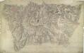
Birmingham 24
1 : 31680 This drawing is attributed to Robert Dawson. Different shades of green are employed to distinguish different land uses, and darker tones to describe the bold undulation of the landscape. Birmingham is depicted top left, at the centre of a network of toll roads and canals. Prominently featured on the plan is the Grand Junction Canal. This waterway was at the heart of the Industrial Revolution in this region at the beginning of the 19th century, carrying raw materials to mills and industrial centres, and finished goods to markets throughout Britain. Dawson, Robert
Coventry and Rugby - OS One-Inch Map
1 : 63360 Topographic maps Ordnance Survey Ordnance Survey
The counti of Warwick the shire towne and citie of Coventre described
1 : 1
Leicestrensis comitatvs
1 Karte : Kupferdruck ; 37 x 48 cm Blaeu Joan Blaeu
Leicestrensis Comitatus cum Rutlandiae vulgo Leicester & Rutland Shire
1 : 160000 Amstelodami : ex. Joannes Janssonius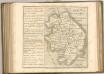
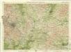
Birmingham, Leicester, Sheet 18 - Bartholomew's "Half Inch to the Mile Maps" of England & Wales
1 : 126720 Topographic maps Bartholomew, John George John Bartholomew & Co
An accurate map of the counties of Leicester and Rutland
1 Karte : Kupferdruck ; 52 x 68 cm Bowen; Tinney; Bowles; Sayer; Bowles; Bowles printed for I. Tinney at the Golden Lion and R. Sayer at the Golden Buck in Fleet street T. Bowles in St. Paul's Church yard and I. Bowles and son at the Black Horse in Cornhill
Leicestrensis comitatvs cum Rvtlandiæ vulgo Leicester [and] Rutland Shire
1 Karte : Kupferdruck ; 42 x 52 cm Valck; Schenk penes Gerardum Valk et Petrum Schenk