Maps of Al Hudud ash Shamaliyah
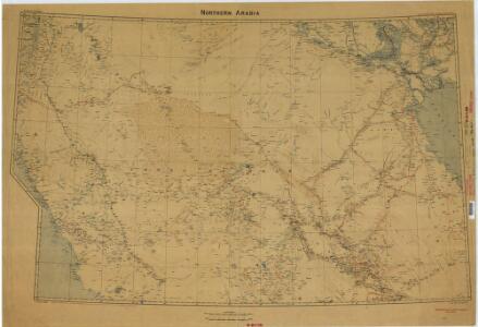
Kuwait, Shakespeare’s last journey (1922)
Overprinted on Northern Arabia, this map shows the journey of Captain Shakespeare from Kuwait to Riyadh and thence west towards Egypt. To accompany Geographical Journal of May 1922. Great Britain. General Staff. Geographical Section. [London] : [GSGS, War Office]
Partie, Pays de Nedjd. Asie 78.
1 : 1641836 Vandermaelen, Philippe, 1795-1869
Partie, l'Arabie. Asie 77.
1 : 1641836 Vandermaelen, Philippe, 1795-1869
Internationale Weltkarte 1:1000 000
1 : 1000000 Medina (Saúdská Arábie) Generalstab des Heeres, Abteilung für Kriegskarten und Vermessungswesen
Karte von Nordwestarabien
1 : 800000 arabské země Moritz, B. Kgl. Preuss. Landesaufnahme
(Sheet 4). Western Palestine Illustrating The New Testament, also The Talmud and Josephus.
1 : 168960 Kitchener, H.R. (Horatio Herbert)
Sheet XVIII. Palestine Exploration Map.
1 : 63360 Kitchener, H.R. (Horatio Herbert)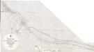
Persian Gulf. Shatt al Arab. Sheet v. Tuwaila I. to Coal I. Natural scale 1 : 25,000
One map on sheet: [Persian Gulf. Shatt al Arab. Sheet v. Tuwaila I. to Coal I. (Basra and Ma'qil. From surveys ... to 1924. Natural scale 1 : 12,500)] London: Admiralty, [1958]
Persian Gulf. Shatt al Arab. Sheet v. Tuwaila I. to Coal I. Natural scale 1 : 25,000
One map on sheet: [Persian Gulf. Shatt al Arab. Sheet v. Tuwaila I. to Coal I. (Basra and Ma'qil. From surveys ... to 1924. Natural scale 1 : 12,500)] London: Admiralty, [1939]
Plan de la partie inférieure de Ouadi Mousa
Wadi Musa (Jordánsko : údolí) Berthe Gide fills
The Land Of Moriah Or Jerusalem and the Adjacent Country.
1 : 76000 Finley, Anthony
[Kaart], uit: [Kaart van Jeruzalem]
1 : 15000 Annotatie: Met register; Tekst in het Hebreeuws [S.l. : s.n.]
Abadan (1926)
Abadan. From a survey by the Port Directorate, Basra, 1924. London : Admiralty
Topographischer Plan von Jerusalem im Jahre 1837
1 : 9500 Jeruzalém Blumenthal, J. Engel, Hermann
Persian Gulf. Shatt al Arab. Sheet v. Ashar and Ma’qil. (1958)
One map on sheet: [Persian Gulf. Shatt al Arab. Sheet v. Tuwaila I. to Coal I. (Basra and Ma'qil. From surveys ... to 1924. Natural scale 1 : 12,500)] London: Admiralty, [1958]
Ordnance Survey of Jerusalem
1 : 10000 Wilson, C. W
Persian Gulf. Shatt al Arab. Sheet v. Ashar and Ma’qil.(1939)
One map on sheet: [Persian Gulf. Shatt al Arab. Sheet v. Tuwaila I. to Coal I. (Basra and Ma'qil. From surveys ... to 1924. Natural scale 1 : 12,500)] London: Admiralty, [1939]
[Kaart], uit: Jerusalem old and new / drawn by Shlomo Ben David
1 : 9000 titelvariant: Steimatzky's pictorial map Jerusalem; Annotatie: Omslagtitel: Steimatzky's pictorial map Jerusalem; Verso: toeristische informatie; Annotatie geografische gegevens: Met schaalstok Shlomo Ben David 1906- [S.l. : Steimatzky]
Plan von Jerusalem
Jeruzalém Kiepert, Heinrich Berndt, E. Simon Schropp & Co.
Basra-shuʿaiba 1:10,000, 1940 (Sheet 3)
Basra-shuʿaiba 1:10,000. Compiled from air photographs taken on 24 and 25 Oct., 1939 by the R.A.F. Survey of India. Risalpur : Survey of India Offices

Basra-shuʿaiba 1:10,000, 1940 (Sheet 4)
Basra-shuʿaiba 1:10,000. Compiled from air photographs taken on 24 and 25 Oct., 1939 by the R.A.F. Survey of India. Risalpur : Survey of India Offices
Basra-shuʿaiba 1:10,000, 1940 (Sheet 9)
Basra-shuʿaiba 1:10,000. Compiled from air photographs taken on 24 and 25 Oct., 1939 by the R.A.F. Survey of India. Risalpur : Survey of India Offices
Basra-shuʿaiba 1:10,000, 1940 (Sheet 10)
Basra-shuʿaiba 1:10,000. Compiled from air photographs taken on 24 and 25 Oct., 1939 by the R.A.F. Survey of India. Risalpur : Survey of India Offices
Plans of towns in Kuwait. GSGS 4879, (1956) Ahmadi Mina-al
[Plans of towns in Kuwait.] GSGS 4879. [London] : D. Survey, War Office and Air Ministry
Plans of towns in Kuwait. GSGS 4879, (1958) Ahmadi Mina-al
[Plans of towns in Kuwait.] GSGS 4879. [London] : D. Survey, War Office and Air Ministry
Jerusalem und Umgegend
Jerusalem Kreuzzüge
Plan de Jérusalem
1 : 85000 Wilson, V Hachette & Cie
Plan of Jerusalem / A.H. Dufour del.
1 : 10000 Annotatie: Engraved for "Three years in the East". &a Dufour, Auguste Henri [S.l. : s.n.]