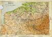
Maps of Belgium
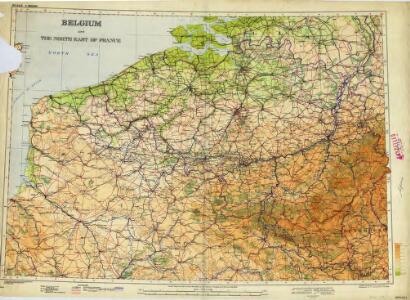
Belgium and the North of France (1938)
Belgium and the North East of France.
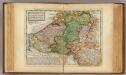
Belgium Regium divisum in decem provincias, nempe ducatus Brabantiae, Limburgi, Lucisburgi, Geldriae ; comitatus Flandriae, Artesiae, Namurci, Hannoniae, Marchionatum Antverpiae, Imperium Machliniensis, ceterasque adsitas regiones delineatum
1 : 650000 per Gerardum et Leonardum Valk [Amsterdam] : Gerard et Leonard Valk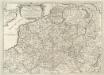
Prouincie Meridionali de Paesi Bassi. Intese sotto nome di Fiandra ouero Li Paesi Bassi Cattolici
1 : 875000 Mollova mapová sbírka Sanson, Nicolas Widman, Giorgio De Rossi, Giovanni Giacomo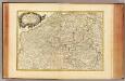
Pays Bas meridionale.
1 : 970000 Janvier, Jean
XXIII Tableau, uit: Carte chorographique des Pays-Bas Autrichiens / ... par le Comte de Ferraris ; gravée par L.A. Dupuis
1 : 86400 Annotatie: Lit.: Les militaires et la cartographie des Pays-Bas méridionaux et de la Principauté de Liège à la fin du XVIIe et au XVIII siècle / Claire Lemoine-Isabeau. - Bruxelles, 1984, p. 206-212; La cartographie au XVIIIe siècle et l'oeuvre du Comte de Ferraris (1726-1814) : colloque international, Spa, 8-11 sept. 1976. - Bruxelles, 1978; Met opdracht aan keizer Joseph II (bl.XVI); Met plattegrond van Brussel (bl. XXI), overzichtskaart (bl. XXII) en bladwijzer (bl. XXIII); Ontbreekt: bl. I-III en XXI; Voor aanwezige bladen zie overzichtsblad Ferraris, Johann Joseph; Dupuis, L. A. [S.l. : s.n.]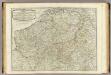
The Catholic Netherlands.
1 : 630000 Kitchin, Thomas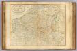
Seat of war Netherlands.
1 : 630000 Robert Laurie & James Whittle
The theatre of the present war in the Netherlands : being an improvement of a large map of the Low Countries by Mr. La Rouge : with the addition of the adjacent parts of England, Germany and the United Provinces
1 : 350000 Annotatie: Met plaatsnamenregister (met coördinaten en afstanden t.o.v. Londen, Parijs en Den Haag) London : printed for R. Wilkinson ... and Bowles & Carver
Provinciae Belgii Regii Distinctae eo, quo Sunt hodie divisae modo Inter Regem Galiae, Hispaniae et Ordines Provinciarum Faederatarum
1 : 740000 Mollova mapová sbírka Danckerts, Justus Danckerts, Justus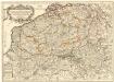
Les Provinces des Pays-Bas Catholiques distinguées suivant qu'elles sont presentement partagées entre le Roy de France le Roy d'Espagne et les Estats Generaux des Provinces Vnies
1 : 680000 Mollova mapová sbírka Cordier, Louis Jaillot, Alexis Hubert
Provinciae Belgii regii distinctae eo, quo sunt hodie divisae modo inter regem Galliae, Hispaniae et ordines provinciarum faederatarum tabula novissima et accuratissima
1 : 740000 1 Karte : Kupferdruck ; 49 x 56 cm Danckerts, Justus [Danckerts]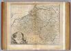
Netherlands or Low Countries.
1 : 980000 Bowen, Emanuel
Provinces des Pais Bas
1 : 800000 Mollova mapová sbírka Fer, Nicolas de Starckman, P. Fer, Nicolas de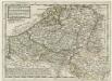
Flanders or the Austrian Netherlands
1 : 1400000 Mollova mapová sbírka Moll, Herman
Ravensteins Deutsche Kriegskarten: Belgien und angrenzendes Frankreich von der ...

Les Provinces des Pays-Bas Catholiques [...] [Karte], in: Atlas nouveau, contenant toutes les parties du monde [...], Bd. 2, S. 20.
1 Karte aus Atlas Sanson, Nicolas Jaillot, Alexis Hubert und Mortier, Pieter
Nieuwe en naukeurige kaart der tien catholijke Nederlanden, uit de beste autheuren en beroemste heedendaagsche kaarten opgemaakt, en volgens sterekundige waarnemingen in orde gebragt
1 : 850000 door Eman. Bowen verb. door W.A. Bachiene ; J. v. Jagen fecit, 1775 [Amsterdam] : [Matthijs Schalekamp]
Kriegskarte von Belgien und angrenzendem Frankreich
Flanders or the Austrian Netherlands.
1 : 1400000 Moll, Herman, d. 1732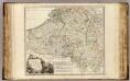
Pays-Bas Catholiques, Luxembourg.
1 : 630000 Robert de Vaugondy, Gilles, 1688-1766
Des Burgundischen Creisses Südlicher theil oder Oesterreichissche Niederlande
1 : 2250000 Mollova mapová sbírka Weigel, Christoph Weigel, Christoph I. - dědici
Belgivm Regivm accuratissime descriptum
1 : 1200000 Mollova mapová sbírka Weigel, Christoph Kauffer, Michael Weigel, Christoph I.
Arena Martis in Belgio
1 : 830000 Mollova mapová sbírka Homann, Johann Baptist
Belgii Regii Accuratissima Tabula
1 : 620000 Mollova mapová sbírka Wit, Frederik de Ottens, Josua
[Recto], uit: Kriegskarte von Belgien und angrenzendem Frankreich
1 : 300000 Frankfurt a.M. : Ravenstein
Circvlvs Bvrgvndicvs
1 : 732700 Belgie Mayer, Tobias Cassini de Thury Homannianis heredib.
Belgivm catholicvm seu Decem provinciae Germaniae inferioris
1 : 732700 Belgie Mayer, Tobias Cassini de Thury Homannianis heredib.
Austrian French and Dutch Netherlands.
1 : 1030000 Carey, Mathew
Austrian French and Dutch Netherlands.
1 : 1020000 Carey, Mathew