Maps of Mesnil-Martinsart

Trench Maps of the Battle Front in France and Belgium, Gruigies (SE)
[Trench Maps of the Battle Front in] Belgium and parts of France. Scale, 1: 20,000. Shows trenches, wire entanglement, etc. With a Glossary printed on the back of the sheets. [London] : [Geographical Section, General Staff].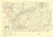
Trench Maps of the Battle Front in France and Belgium, Beaumont
Trench Maps [of the Battle Front in France and Belgium, showing trenches, wire entanglement, etc. With a Glossary printed on the back of the sheets]. Scale, 1: 10,000.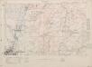
Trench Maps of the Battle Front in France and Belgium, Ovillers
Trench Maps [of the Battle Front in France and Belgium, showing trenches, wire entanglement, etc. With a Glossary printed on the back of the sheets]. Scale, 1: 10,000.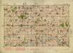
Albert. Scale, 1: 40,000. First edition
Albert. Scale, 1: 40,000. First edition. [London] : [Geographical Section, General Staff]
Battle of the Somme: August 1916
1 : 80000 Battle of the Somme. Situation in August, 1916. War Office
Battle of the Somme: July 1916
1 : 80000 Battle of the Somme. Situation in July 1916. War Office
Map of the Somme Front.
1 : 40000 First World War map of the Somme Front. Advances between July 1st 1916 and 28th Feb 1917. War Office
Somme Front 1916: Allied lines in Oct. and Nov.
1 : 40000 First World War map of the Somme Front. Allied lines in Oct. and Nov. 1916. War Office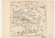
Map showing front lines around Bapaume, France, in 1916 Fron Line 1916
1 : 885000 Fron Line 1916 H. & C. Graham Ltd. Lithrs. London : Stanford's Geogl. Estabt.
Map of the Somme area.
1 : 40000 First World War map showing progress in Arras area. December 1916. War Office
Map of the Somme area. Dec. 1916.
1 : 40000 First World War map of the Somme area. Dec.1916. Same map with Japanse characters at Maps 17535(3) and Russian at Maps 17535(4). War Office
Carte du gouuernement de Bappaume
1 Karte : Kupferdruck ; 11 x 15 cm s.n.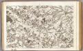
4 Abbeville.
1 : 86400 Cassini family; Cassini, Cesar-Francois, 1714-1784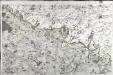
[Abbeville - Arras]
1 Blatt : 60 x 91 cm Le Roy s.n.
Cambrai-Saint Quentin. Scale, 1 : 100,000 or 1 inch to 1.58 miles
Cambrai-Saint Quentin.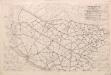
Third Army Traffic Map: June 1918
1 : 100000 First World War Third Army Traffic Map. June 1918. Overprinted on sheet 'Third Army administrative map'. Shows direction traffic must take, speed of vehicles, where not to take horses and mules. War Office
Veromandui
1 Karte : Kupferdruck ; 34 x 38 cm Sanson; Robert de Vaugondy; Cordier chés le Sr. Robert geog. du r. quai de l'Horloge
Ambiani
1 Karte : Kupferdruck ; 38 x 40 cm Sanson; Robert de Vaugondy; Cordier chez le Sr. Robert g. du r. quai de l'Horloge
Arras, Peronne, Noyon, uit: Le conflict mondial : front occidental
1 : 170000 Annotatie: Ontbreekt: no. 1 en 5-8 Gand : Th. de Graeve
Stanford's half-inch map of the British front in France and Flanders
1 : 126720 Shows line of battle in June 1916 and updated line of battle in June 1917.Relief shown as gradient tints.Shows: railways, roads, woods. Edward Stanford Ltd. [London] : Edward Stanford Ltd.
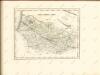
Partie Meridionale de Picardie
1 : 208000 Mollova mapová sbírka Delisle, Guillaume L'Isle, Guillaume de
Amiens 95, uit: Special-Karte von Mittel-Europa / nach amtlichen Quellen bearbeitet von W. Liebenow
1 : 300000 titelvariant: W. Liebenow's Mittel-Europa; Annotatie: Titel boven de bladen: W. Liebenow's Mittel-Europa Johannes Wilhelm Liebenow 1822-1897 Frankfurt a. M. : Ludwig Ravenstein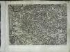
Artesia
1 Karte : Kupferdruck ; 21 x 30 cm Quad; Bussemacher Johannes Bussemacher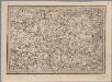
[20], uit: Hydro-Oro und Chorographische General Karte des Koenigreichs der Niederlande und der angrenzenden Länder bis Paris : mit der Angabe der Kunst und Heer-Strassen und der Entfernung der Poststationen / ... zusammengetragen und reducirt von ... Wilhelm Müller
1 : 400000 titelvariant: Generalkarte des Koenigreichs Hannover; Annotatie: 1e supplement bij: Generalkarte des Koenigreichs Hannover (1818) Müller, Wilhelm (fl. 1818) [Hannover : Wilhelm Müller]
Amiens 95, uit: [W. Liebenow's Special-Karte von Mittel-Europa]
1 : 300000 titelvariant: W. Liebenow's Mittel-Europa; Annotatie: Titel boven de bladen: W. Liebenow's Mittel-Europa Johannes Wilhelm Liebenow 1822-1897 Hannover : Hermann Oppermann
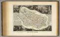
Carte d'Artois et des Environs
1 : 208000 Mollova mapová sbírka Delisle, Guillaume L'Isle, Guillaume de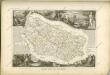
Dept. Des De La Somme.
1 : 378000 Levasseur, Victor.


