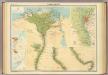
Maps of Alexandria
A plan of the cities of Alexandria
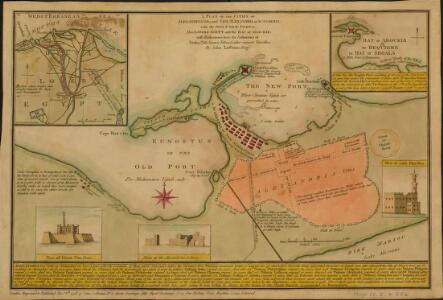
A plan of the cities of Alexandria vetus, and New Alexandria or Scanderia; with the old and new ports: also Lower Egypt and the Bay of Aboukir: with illustrations from the authorities of Norden, Tott, Volney & other eminent travellers / by, John Luffman, Geogr. Shows ancient and modern Alexandria. Text describes history of Alexandria and its rulers up to 1798. -- Inset of Bay of Aboukir includes brief description of the Battle of the Nile (July 1798). -- A second state published in The Naval Chronicle, 1807. Luffman, J. (John), 1756-1846 London: engraved & published Nov.r 5th, 1798, by John Luffman, no.2, Inner Sweetings Alley Royal Exchange. Price one shilling, plain, eighteen pence, coloured
[Sketch of Alexandria : reconstruction of historical places]
[S.l.] : [s.n.]
Geometrischer Grundiss der Stadt Alexandria
1 : 158000 Alexandrie (Egypt) Ausfeld, Johann Carl Gleditsch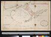
Afteekening van de haven van Alexandria agter in de Middellandsche Zee, aen de kust van Barbarija in Egypte
Egypt Laurent Brémond Gerard van Keulen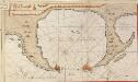
De haven van Alexandria
Egypt Gerard van Keulen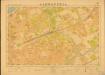
Egypt. Town Series, Alexandria (Sheet 20)
Egypt. Town Series ... Alexandria. Scale 1: 5,000. [El Giza] : Survey of Egypt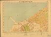
Egypt. Town Series, Alexandria (Sheet 14)
Egypt. Town Series ... Alexandria. Scale 1: 5,000. [El Giza] : Survey of Egypt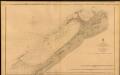
The Port of Alexandria, Egypt
The Port of Alexandria. Surveyed by Lieut. E. W. Brooker, etc. 1857. [Admiralty Chart] London
Stadtplan von Alexandria, 1:15,000
Stadtplan von Alexandria, 1:15,000. Germany. Luftwaffe Berlin : Luftwaffe.
Piano dei due porti di Allesandria, e posezione della squadra Turco-Egizia in Agosto 1831
1 : 43000 Alexandrie (Egypt)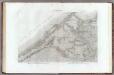
37 Alexandrie.
1 : 100000 Jacotin, Pierre, 1765-1827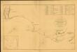
Chart of the Coast of Egypt, from Alexandria to the Western Branch of the Nile
Chart of the Coast of Egypt, from Alexandria to the Western Branch of the Nile; with the Bay of Aboukir, shewing the position of the French and English Fleets, at the Battle of the Nile, August 1, 1798. London : A. Arrowsmith.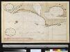
Afteekening van een gedeelte van de kust van Egipten vertoonende de haven van Alexandria ent land daer beoosten
Egypt Gerard van Keulen
Plan of the Operations of the British & Ottoman Forces in Egypt, From the 8th. of March to the 2d. of Sept.r 1801, when the French were Finally expelled from that Country
Neele, Samuel John Arrowsmith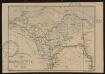
Carte de la Basse Egypte
1 : 1500000 Société de géographie de Toulouse Toulouse : Lith. Cussan Fils
Das Nil - Delta und der Sues-Kanal

Das Nil-Delta und der Sues-Kanal
1 : 800000 Egypt Ed. Hölzel
Carte de la Basse, Égypte et du Canal Maritime de Suez
1 : 500000 Suezský průplav (Egypt) Desbuissons, Edouard Méa, Paul E. Andriveau-Coujon
Communications map of lower Egypt and the Fayum
1 : 300000 Egypt Survey of Egypt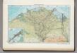
163. Nile Delta, Suez Canal, Alexandria. The World Atlas.
1 : 750000 USSR (Union of Soviet Socialist Republics).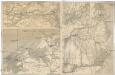
[Nil-Delta]
1 : 1000000 Alexandrie (Egypt) Mitterwallner, J.
Das Nil-Delta und der Sues-Kanal
1 : 800000 Egypt Eduard Hölzel
Egypt.
1 : 900000 Rand McNally and Company
Carte De L'Egypte et des Postes Militaires occupés et Fortifiés par les Français sous les ordres du Géneral en Chef Bounaparte, depuis leur invasion le 1. Juillet 1798, jusqu'à ce jour; Dressée d'après les relations fidelles des Chefs interceptées, et sur le compte qui en a eté rendu par les deserteurs
Kauffer, François
Aegypti Recentior Descriptio. [Karte], in: Theatrum orbis terrarum, S. 311.
1 Karte aus Atlas Ortelius, Abraham
[Ägypten] [Karte], in: Gerardi Mercatoris Atlas, sive, Cosmographicae meditationes de fabrica mundi et fabricati figura, S. 499.
1 Karte aus Atlas Mercator, Gerhard Montanus, Petrus
Aegypti Recentio Descriptio. [Karte], in: Theatrum orbis terrarum, S. 120.
1 Karte aus Atlas Ortelius, Abraham
Abrahami patriarchae peregrinatio, et vita
1 : 2200000 Egypt Ortelius, Abraham Moflinius, Iohannes Abraham Ortelius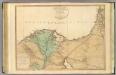
Lower Egypt, Palestine.
1 : 755000 Faden, William, 1750?-1836