Maps of London

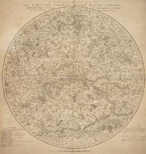
A TOPGRAPHICAL MAP OF THE COUNTRY TWENTY MILES ROUND LONDON
In the second half of the18th century, the introduction of turnpike roads and the increased coach-traffic in and out of London contributed to the popularity of the maps of the countryside around the capital. The title of this circular map runs along the top, with points on the compass marked on the border. A list of main roads to and from London is provided at bottom left, with a key at bottom right and scale bar below the plan. Faden, William
A NEW and CORRECT MAP of the COUNTRIES TWENTY MILES Round LONDON.
In the second half of the18th century, the introduction of turnpike roads and the increased coach-traffic in and out of London contributed to the popularity of the maps of the countryside around the capital. This map was published in Henry Chamberlain's 1770 'A New and Compleat History and Survey of the Cities of London and Westminster.' The map's title features along the top, with a scale bar and explanatory note below the plan, and border divided in degrees of latitude and longitude. Churches, hills and other architectural or geographical landmarks are indicated by symbols. Market towns are marked by stars. Bowen, Thomas
Public open spaces
1 : 189000 Waterlow & sons
Environs of London.
1 : 93000 Colton, G.W.
ANDREWS'S NEW AND ACCURATE MAP OF THE COUNTRY THIRTY MILES ROUND LONDON
In the second half of the 18th century, the introduction of turnpike roads and the increased coach-traffic in and out of London contributed to the popularity of the maps of the countryside around the capital. This is the second edition of Andrews' 1782 survey. The map's title features in a panel above the plan, with county boundaries outlined in colour, parks in green and main roads in yellow. The border of the map is divided in degrees of latitude and longitude. Andrews, John
Delineatio ac finitima regio Magnæ Brittaniæ metropoleos Londini
1 Karte : Kupferdruck ; 48 x 57 cm Lotter Tobias Konrad Lotter
Les environs de Londres
1 Karte : Kupferdruck ; 47 x 53 cm chez I. Côvens et C. Mortier
Map showing the general Boundaries of the GENERAL POST DELIVERY; of the FOREIGN DELIVERY; of the Town Delivery of the Two penny Post Department; and of the COUNTRY DELIVERY
This map of the area round London was produced by order of the House of Commons for the 21st report of the Commissioners of Revenue Inquiry. The map's title is at top right with areas of various postal delivery services highlighted in colour. Basire, James
Outer London.
1 : 106065 Stanford, Edward
Les environs de Londres
1 Karte : Kupferdruck ; 47 x 55 cm Le Rouge par et chez le Sr. le Rouge ingenieur geographe du roi rue des Augustins vis a vis le panier Fleury
60. London. The World Atlas.
1 : 250000 USSR (Union of Soviet Socialist Republics).
Leigh's new map of the environs of London
1 : 247000 drawn and engraved by Sidy. Hall, 14 Bury St., Bloomsby London : Leigh
Delineatio ac finitima regio Magnae Brittaniae metropoleos Londini
1 : 120000 ad novissimam Normam repraesentata et excusa a T. Conr. Lotter, Augustano Chalcogr. Et Geogr. [Augsburg] : [Tobias Konrad Lotter]
An accurate MAP of the Country TWENTY MILES round LONDON. From GRAVESEND to WINDSOR East and West, and from ST. ALBANS to WESTERHAM North and South with the CIRCUIT of the PENNY POST
In the second half of the18th century, the introduction of turnpike roads and the increased coach-traffic in and out of London contributed to the popularity of the maps of the countryside around the capital. The title of this plan runs along the top, with borders divided in degrees of latitude and longitude, county boundaries outlined in colour and the circuit of the Penny Postmarked in red. Before William Dockwra set up the Penny Post in 1680, there was no local delivery of letters in London, except by private courier. Dockwra opened seven sorting offices and hundreds of receiving houses. Letters were delivered to addresses in London for the charge of a penny, paid by the sender. An extra penny was charged for deliveries in the London Country area within ten miles of the city. In 1682, the Post Office took over the running of the service. Cary, John

REGIONIS, qvae est circa LONDINVM, specialis repraesentatio geographica
1 : 190000 Bowles, Thomas curantibus Homan[n]ianis Heredibus
Middelsexiæ cum Hertfordiæ comitatu
1 Karte : Kupferdruck ; 42 x 52 cm Valck; Schenk apud G. Valk et P. Schenk
Middelsexiae cum Hertfordiae Comitatu = Midlesex & Hertford Shire
1 : 160000 Amstelodami : apud Joannem Janssonium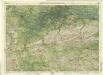
Surrey, Sheet 30 - Bartholomew's "Half Inch to the Mile Maps" of England & Wales
1 : 126720 Topographic maps Bartholomew, John George John Bartholomew & Co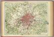
London.
1 : 126720 John Bartholomew & Co.
Environs of London
1 : 63360 W.H. Smith & Son W. H. Smith & Son
THE ENVIRONS OF LONDON
This map of London and part of the Home Counties was published in Pinnock's 'Guide to Knowledge'. Reduced from an original Ordnance Survey drawing, the map is printed in white on black, with the title in inset table at top centre. Though none of the sheets of the first edition of the Ordnance Survey covered London, part of the metropolitan area was contained in the maps of Middlesex, Essex, Surrey and Kent issued between 1805 and 1822. Archer, Joshua
Middle-Sexia. [Karte], in: Theatrum orbis terrarum, sive, Atlas novus, Bd. 4, S. 263.
1 Karte aus Atlas Blaeu, Joan Blaeu, Willem Janszoon
MAP of the COUNTRY 15 MILES ROUND London SHEWING BY A YELLOW CIRCLE OF 3 MILEs, THE LIMITS OF THE TWOPENNY POST DELIVERY
This map was commissioned by the House of Commons for the ninth report of the Post Office Management. The map's title features at top right, with an explanatory note and scale bar at bottom right. It shows the boundaries of the London Two-Penny Post, and the old and current boundaries of the Country Three-Penny Post, with mail routes highlighted in red. Post stages on the edges of the post area allowed mail to be exchanged between the London and the General Post on all main roads out of London. Wyld, James
Delineatio ac finitima regio Magnae Brittaniae metropoleos Londini
Londýn (Anglie) Seutter, Matthäus a Matt. Seutter
Middle-Sexia. [Karte], in: Theatrum orbis terrarum, sive, Atlas novus, Bd. 4, S. 263.
1 Karte aus Atlas Blaeu, Joan Blaeu, Willem Janszoon
Middle-Sexia. [Karte], in: Le théâtre du monde, ou, Nouvel atlas contenant les chartes et descriptions de tous les païs de la terre, Bd. 4, S. 233.
1 Karte aus Atlas Blaeu, Willem Janszoon und Blaeu, Joan Blaeu, Willem Janszoon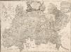
A MAP of the COUNTY of MIDDLESEX Reduced from An Actual Survey in four sheets by John Rocque
The title of this plan appears in decorative cartouche at top centre, with a note on the county's extension and division into parishes at top right. A compass star is included at bottom centre. Scale is given in miles and perches (intervals of around16.5 feet)at bottom left and the border of the map is divided in degrees of longitude from the old meridian of St. Paul's. Symbols are used to indicate land use and reliefs. Rocque, John
London N.W. - OS One-Inch Map
1 : 63360 Topographic maps Ordnance Survey Ordnance Survey