Maps of Tower Hamlets

LONDON 269
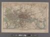
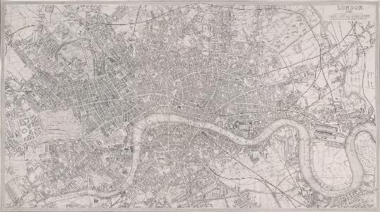
This map of Victorian London was produced for publication in the Post Office Directory of 1852. The map's title and imprint appear at top right. It shows the entire London railway system. With the exception of Blackfriars and Marylebone stations, all London termini were built in the between 1736and 1876. As the railway companies scrambled to buy land to redevelop central London, many people, mainly slum-dwellers, were left homeless or forced to move to outer suburbs like Tottenham and Edmonton. Davies, Benjamin Rees
LONDON 1849 DRAWN & ENGRAVED EXPRESSLY FOR THE POST OFFICE DIRECTORY
This map has been engraved for the Post Office Directory. It is the third edition of a map originally published in 1847. Davis, Benjamin Rees
CARY'S New and Accurate Plan of LONDON AND WESTMINSTER, the Borough of SOUTHWARK and parts adjacent 221
The title of this folding map of London runs along the top, with a list of public buildings at top left, facing a list of churches at top right. Open spaces and the city boundaries are drawn in colour, withal reference table in the panel below the plan. John Cary, who first published this map in 1787, added a sheet to this later edition to include the Lea River, the Isle of Dogs and the new docks. The map also shows the Asylum for the Blind in St. George's Fields and the Penitentiary at Millbank. Cary, John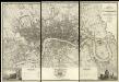
Map of London from an Actual Survey
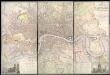
Map of London printed in six sheets from a survey made during the period 1824-26.The map featurestitle and imprint at top right, dedication to King George IV at bottom centre, view of Westminster Abbeywith key to symbols at bottom left and view of St Paul's Cathedral with key to lines at bottom right. Greenwood, Christopher and John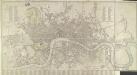
CARY'S New and Accurate Plan of LONDON AND WESTMINSTER, the Borough of SOUTHWARK and parts adjacent 210
This title of this folding map of London appears along the top. Open spaces are depicted in colour with a reference table in a panel below the plan. This is the twelfth edition of the map first issued by Cary in 1787, updated to include several new works of the Regency period. An added sheet extends eastward to include the Isle of Dogs and the East and West India Docks. Cary, John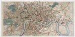
Post office plan of London
Wyld, James, 1812-1887 Ja.s Wyld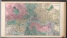
London.
1 : 19500 Society for the Diffusion of Useful Knowledge (Great Britain)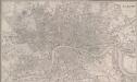
LONDON 270
This map of Victorian London was published in the 'Weekly Dispatch' newspaper of 1756. Its title appears at top right, along with the publisher’s imprint and scale bar. Based on Davies's map of 1847, the map shows London railway termini, the South Western, West London and North Kent lines, and all post-receiving houses and pillars. Cassell, Petter & Calpin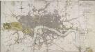
LONDON IN MINIATURE WITH THE Surrounding AN ENTIRE NEW PLAN In which the Improvements both present and intended are actually reduced (by permission) from the surveys of Several Proprietors
The title of this map appears at top right, with scale bar at the bottom centre, and a compass rose near top left. Watercourses, roads and open spaces are depicted in colour. The map shows the proposed new bridges at Waterloo and Vauxhall, extending eastward on an added sheet to include the Isle of Dogs. Mogg, Edward
Bez titulu: London
Map of LONDON From Actual Survey COMPREHENDING THE Various Improvements to 1851HUMBLY DEDICATED TO Her Most Gracious Majesty QUEEN VICTORIA By the Proprietors E. RUFF & Co.
This is a later edition of the Greenwoods' map of London first issued in 1827. Set within a decorative border, the map features title at top right, view of Westminster Abbey with key to symbols and colours at bottom left and view of St. Paul's Cathedral with reference table at bottom right. Greenwood, Christopher and John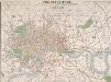
THE CIRCUITEER. A SERIES OF DISTANCE MAPS FOR ALL THE PRINCIPAL TOWNS IN THE UNITED KINGDOM. INVENTED BY J. FREDERICHS AS A GUIDE FOR ASCERTAINING CAB FARES, PORTERAGE &c. &c.
The title of this map of Victorian London appears at top centre, with a scale bar at the foot of the plate. The map is divided into circles, each a half-mile in diameter, allowing the reader to ascertain the distance between two places at a glance. Each circle is also numbered for reference, with a key to the principal streets and squares a in panel below the map, together with an explanatory note. Repeated in French and German, this note reports London cab fares, set by Act of Parliament at 8d (pence) per mile and 4d for every additional half mile. Frederichs, J.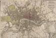
PIGOT & Co New Plan of London Taken from the Best Authorities
The title and publisher's imprint of this map appear at the top right, facing an explanatory note at top left. Squares, open spaces and the built-up area in the city are delineated in colour. A key to colours is provided at the bottom left. Published in Pigot's 'Metropolis Guide and Book of Reference', the map is divided into circles numbered for reference, showing Waterloo, Vauxhall and Battersea Bridges. Pigot, James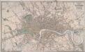
LAURIE'S PLAN OF LONDON, WESTMINSTER AND SOUTHWARK Trigonometrically Surveyed by JOHN OUTHETT
This is a later edition of the folding map first issued by Laurie in 1837. The map features title at top right, key to colours and scale of 40 acres at bottom centre. The border of the map is divided in miles and furlongs from St Paul's Cathedral and seconds of longitude east and west of Greenwich. Laurie, Richard Holmes
LONDON AT ONE VIEW: A NEW MAP
Map of London with title along the top, scale bar at top left and statistical note below the map. Down both sides of the map are views of London prominent buildings and landmarks. Nelson Column, Westminster Hall, Horse Guard, Buckingham Palace and Burlington Arcade are depicted down the left of the map and the Monument, St Paul's Cathedral, Guildhall, the Royal Exchange, Temple Bar and the Thames Tunnel down the right. Biggs, George
THE RAILWAY BELL AND THE ILLUSTRATED LONDON ADVERTISER MAP OF LONDON
This is a special edition of Biggs's map of London of 1842 for subscriber to the Illustrated London Advertiser. The map features title at the top superimposed to a view of the Thames at St Paul's and views of public buildings down both sides and along the bottom of the plan, with portraits of Queen Victoria and Prince Albert at bottom centre. Biggs, George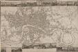
LANGLEY & BELCHE'S NEW MAP OF LONDON
Proof before letters is the term for an impression of a print withdrawn before the title is added to the image prior to publication. This is a proof before letters copy of Langley & Belche's 1812, with illustrated views of prominent London buildings (including the newly opened docks) along the top and bottom of the plate. The plan is divided into lettered squares for reference. It was originally accompanied by Langley & Belch's street directory or 'Companion to their new map of London'. Langley, Edward & Belch, William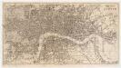
Reynolds's map of London : with the latest improvements
1 : 16000 Martin, Henry, fl. 1830-1852 J. Reynolds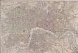
London 257
This untitled map of London features scale bar at top left. The city boundary is marked in red, with open land, such as parks and gardens, in green, and the Thames, docks and canals in blue. The map clearly labels the contemporary development of the railway lines, with the Birmingham railway shown intersecting the Regent's Canal at Camden Town. The canal, enthusiastically promoted by architect John Nash, was built to facilitate the import of goods from the provinces. Constructed at the beginning of the era of sustained railway development, however, it never fulfilled its potential and became obsolete.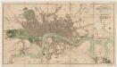
London in miniature : with the surrounding villages, an entire new plan in which the improvements both present and intended are actually reduced (by permission) from the surveys of the several proprietors : the whole laide down from the best authorities
1 : 16000 Mogg, Edward Edward Mogg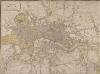
LAURIE and WHITTLE NEW MAP OF LONDON WITH ITS ENVIRONS &C. Including the Recent Improvements
The title of this map of London and suburbs appears at top left, with the key to symbols and abbreviations at the top right and a compass rose at the bottom centre. The map is divided into mile squares with borders marked off in furlongs for reference. Squares, open spaces and city boundaries are distinguished in colour. This is a later edition of a map first issued in 1804, updated to include the new bridges and the approaches at Waterloo and Vauxhall (indicated by dotted lines). Built between 1809 and 1819, Vauxhall, Waterloo and Southwark bridges were projected, funded and constructed by private commercial companies hoping to profit from toll-paying traffic from Lambeth, Camberwell and the rest of south London. Laurie, Robert and Whittle, James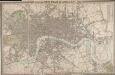
CROSS'S NEW PLAN OF LONDON 1828
The title of this folding map is inset in the top border, with the publisher's imprint and explanatory notes in the bottom border and a list of parishes in a table at top right. The map is divided into half-mile squares for reference, with the river, open spaces and the boundaries of London, Westminster and Southwark highlighted in different colours. Cross, Joseph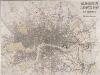
MOGG'S LONDON AND ITS ENVIRONS Drawn from The latest Surveys
The radius of the red circle on this map (above St. Paul's) extends for three miles around the Post Office. The Post Office was erected on the site of St Martin-le-Grand. Designed by Sir Robert Smirke, it was opened in 1829. Coloured roads represent omnibus routes. Buses gradually replaced hackney coaches after the hackney's monopoly ended in1832. The site of the 1851 Great Exhibition in Hyde Park is indicated. Mogg, E.S.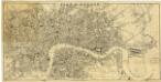
London[Plan of]. Drawn expressly for the Post Office
Wyld, J.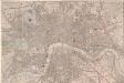
London at a View: a New Map
A copy of Bigg's map of London of 1842 lacking the title, the views and the note at the bottom of the map. The map features scale bar and compass rose at top left with main roads in yellow, water courses in blue, parks and open spaces in green and railways in red. Biggs, George
CARY'S New and Accurate Plan of LONDON, WESTMINSTER, the Borough of SOUTHWARK and parts adjacent
John Cary was possibly the most productive English map maker and publisher of the18th Century. His works were reissued many times, but unlike many of his contemporaries he aimed to update each edition by showing new developments. This is the third edition of a map first published in 1787. The developments in Somers Town are shown; the Lambeth and London roads are named. The numerous parks and gardens across the city are coloured green. The map is divided into squares, numbered for reference. Cary, John
Map of London : made from an actual survey in the years 1824, 1825, & 1826
1 : 63360 C. & J. Greenwood C. & J. Greenwood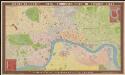
Bauerkeller's new embossed plan of London, 1841
1 : 11500 G. Bauerkeller London [etc.] : Ackermann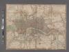
Laurie and Whittle's New map of London with its environs, &c. Including the Recent Improvements.
From Great Britain