Maps of Islington

A Mapp of the Cityies of LONDON & WESTMINSTER & BURROUGH of SOUTHWARK with their Suburbs and the Addition of the New Buildings
The title of this map of London, Westminster and Southwark appears along the top, with a reference table (flanked by sword and mace-bearer) at top left, a figure of Mercury (with the city arms on his shield) at top centre, and a second reference table below city arms at top right. The key to places in Southwark appear in a table at St. George's Fields, with compass star and scale bar at bottom centre and an allegorical figure of Father Thames at bottom right. John Oliver first issued this map in 1680.This is a later edition published and sold by John Bowles from his shop at the Black Horse in Cornhill. Oliver, John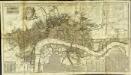
A new and exact plan of the cities of London and Westminster & the borough of Southwark to this present year
1 Plan auf 2 Blättern : Kupferdruck ; 53 x 101 cm Sayer; Bowen printed and published according to act of parliament by Robert Sayer opposite Fetter lane Fleet street
London, Westminster, and Southwark
The map reports all the street names in London, Westminster and Southwark, with the scale bar given at bottom left. Faden, William
Plan of the City of LONDON before the Fire Anno Domini 1666.
This is a retrospective plan of the City of London before the great fire of 1666. Place names are indicated by an alphanumeric key.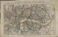
Reynolds's distance map of London, for ascertaining cab fares & shewing the distances in every direction from the railway stations &c.
James Reynolds
LONDON 76
This small map of London and suburbs was included in a small 1707French travel book, "Les Delices de la Grande Bretagne". It features a compass rose at bottom right, and a title with reference panel below the plan. Bevereel, James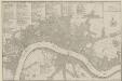
PLANES DES VILLES DE LONDRES ET DE WESTMINSTER et de leurs Faubourges, avec le Bourg de Southwark
The title of this French plan runs along the top of the sheet, with table of references at top left, facing the scale bar and compass rose at top right. This map was included in Nicolas de Fer's "Atlas Curieux". Fer, Nicholas de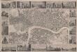
London
This is a "proof before letters", the trade term used for animpression withdrawn by the author before the title and imprint could be added for publication.The map covers London in the 1830s, and is surrounded by small pictorial views of prominent buildings and landmarks including East India House, Marble Arch, Westminster Abbey and Waterloo Bridge. Anonymous
PLAN DE LA VILLE DE LONDRES
This small map of London appeared in a book entitled "Memoires et Observations faites par un Voyageur en Angleterre", published in France by Henry Van Bulderen in 1698. The map is a much-reduced derivative of Joannes de Ram's plan of 1690. This edition features title at top left, city arms at top right and a panorama of London, based on Matthaeus Merian’s view of the city, in a panel below the plan. Ram, Joannes de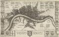
LONDON 45
This map is surveyed by Richard Blome, a heraldic writer and cartographer. Although prolific, he was something of a magpie, borrowing from many sources in the creation of his maps. Engraved by Hollar, this map is dedicated to Sir Robert Vyner, whose coat of arms is depicted at the bottom. The arms of the 12 Great City companies are drawn in the side margins. These companies were the trade guilds of London, many of which have existed from the middle ages to the present day. Hollar, Wenceslaus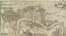
A New & accurate PLAN of the CITIES of LONDON & WSTMINSTER & BOROUGH of SOUTHWARK
This is the sixth edition of a map first published in 1765. It includes views of London landmarks, such as St James's Palace and St Paul's Cathedral, and the arms of the 12 principal City Companies. Dicey was a map seller rather than a cartographer and much of his work is derivative or reissued from earlier plates. This map states that it is printed according to an "Act of Parliament". This makes reference to the Act passed in 1734 to curb the practice of unacknowledged copying. Thereafter, anyone who breached the new 14-yearcopyright period would have to hand over their derivative plates to the master of the original, paying 5 shillings for each offending print on the premises. Cluer Dicey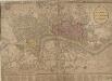
STRANGER'S GUIDE THROUGH the Streets of LONDON and WESTMINSTER
The title of this folding map appears along the top, with the sub-title in an oval at top right. A scale bar and compass star feature at the bottom right. An inset plan of Fleet Prison is included at top left. Squares, open spaces and built-up areas are all delineated in colour. Intended for visitors to the city, the map is divided into squares, with a quick-reference key in the panel below the main plan. Darton, William
LONDINI ANGLIAE REGNI METROPOLIS 71
This map of London, Westminster and Southwark was issued in Peter Van der Aa's "La Galerie Agreable du Monde: Grande Bretagne et Irlande" (Vol. I, Plate 8). It is a later edition of a map first published in Amsterdam byJoannes de Ram at the end of the 17th Century. This edition features title along the top, a key to places in Southwark in cartouche at top left, a reference table at top right, and a bird's-eye view of Westwood Park in Worcestershire at the foot of the plate. The city arms, publisher's imprint, and a monument bearing the title in French appear towards the bottom of the sheet. Aa, Peter van der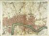
A plan of London
1 Karte : Kupferdruck ; 50 x 66 cm Rocque; Parr publish'd 29.th april according to act of parliament by John Rocque
Londini Angliæ regni metropolis delineatio accuratissima
1 Plan : Kupferdruck ; 34 x 58 cm, Bildgrösse 50 x 58 cm Aa chez Pierre vander Aa libraire imprimeur de l'université et de la ville
PLATTE GRONDT Der Verbrande Stadt LONDON
This map was published in Amsterdam aftermath the great fire of 1666. The title in a banner at top right, flanked by City and Royal arms. The design for rebuilding the City is inset in a panel at top left, with an engraved view of the fire in a banner at bottom centre. Below the plan is a description of the fire in Dutch, French and English with a key to streets and buildings. Doornick, Marcus Willemsz
BOWLES'S Reduced NEW POCKET PLAN of the CITIES of LONDON and WESTMINSTER, with the BOROUGH of SOUTHWARK, exhibiting the NEW BUILDINGS to the YEAR 1787.
This is the sixth edition of Bowles's Reduced New Pocket Plan. The map was reissued 11 times between1777 and 1799. It includes a table of references to churches and principal buildings. The built-up areas of the City of London are represented by stippling; with the city boundaries delineated it red. The scale is given in miles and furlongs. Bowles, Carington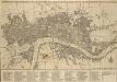
BOWLES'S Reduced NEW POCKET PLAN of the CITIES of LONDON & WESTMINSTER; WITH THE BOROUGH OF SOUTHWARK, exhibiting the New Buildings to the YEAR 1780
The Bowles family were successful map publishers and sellers whose considerable output spanned a century. This map is the second edition of an original 1777plan. It includes a table of references to churches and principal buildings. The built-up areas of the City of London are stippled. The scale is given in miles or furlongs. Bowles, Carington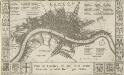
Plan de Londres tel quil Etoit avant l' incendre de 1666 Grave par Hollar
This is a later edition of a 1666map surveyed by Blome and engraved by Hollar. The title appears in French in a panel below the plan, with the key to streets and public buildings appearing in tables at top right, top left and bottom right. A compass star and scale bar are drawn at bottom right. Down both sides of the map are the coats of arms of the 12 Great City Companies (trade guilds), many of which have existed from the middle ages to the present day. Richard Blome was a heraldic writer and cartographer. His maps were often derivative, based on existing sources rather than original surveys. Blome, Richard
Maps of Old London-J. Rocque
Mitton, Geraldine Edith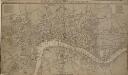
LONDON, WESTMINSTER AND SOUTHWARK, Accurately delineated from the latest Surveys,
John Cary was possibly the most productive maker and publisher of maps in England the 18 Century. His works were reissued many times, but unlike many of his contemporaries he aimed to update each new edition by including new developments. This is the second edition of a map originally published in 1782. The imprint and table of Hackney coach fares (referred to in the description) has been removed from the bottom of the map. Cary, John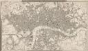
A NEW PLAN OF LONDON AND WESTMINSTER WITH THE BOROUGH OF SOUTHWARK 227
This is the second edition of a map of London first published by Wyld in 1824. Its title features inset in the top border, with publisher's imprint in the bottom border. The scale bar and key to the boundary lines appear at bottom right. The son of a map publisher, James Wyld attended military college before entering the map trade. He became one of the best-known map publishers of the middle of the 19th Century. During the railway-building mania of those years, his maps of railway developments were often put before parliament. Wyld, James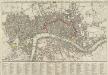
A new Pocket Plan of LONDON WESTMINSTER and SOUTHWARK, with all the Adjacent Buildings. Also a correct List of upwards of 300 Hackney Coach Fares 1797.
Pocket plans were made popular by publisher Thomas Bowles in the 1730s. This later map is coloured to highlight the old London Wall and the parks and open spaces. This map includes a list of Hackney Coach Fares. The development of turnpike roads from the 1750s onwards led to a steady increase of wheeled vehicles such as the Hackney Coach, which eventually made watermen redundant Darton, William and Harvey, Josiah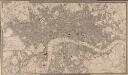
A NEW PLAN OF LONDON AND WESTMINSTER WITH THE BOROUGH OF SOUTHWARK 222
The title of this map appears in a table inset in the top border, with publisher's imprint, scale bar and an explanation of the boundary lines at bottom right. The son of a map publisher, James Wyld attended military college before entering the map trade. He became one of the best-known map publishers of the middle of the 19th Century. During the railway-building mania of those years, his maps of railway developments were often put before parliament. Wyld, James
A Plan of LONDON and WESTMINSTER, shewing the Forts erected by order of the Parliament in 1643, and the Desolation by the Fire in 1666
This is a retrospective plan of London, showing the1643 defences for the civil war and the area destroyed by the Great Fire. These defences were built to protect the city from attacks by Charles I and his 15,000 Royalist troops. Here all 23 forts are shown, linked by eighteen miles of ramparts. The Royalists never attempted to enter London because the King made a tactical withdrawal.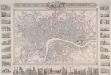
PLAN OF LONDON FROM AN ACTUAL SURVEY 243
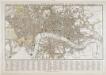
This is a later edition of Shury's map of London first issued in 1832. The map features title along the top with the arms of the cities of London and Westminster. Down both sides of the map and along the bottom are 33 views of London buildings and landmarks. The East India House, Custom House, the Mint, St James's Palace, Christ's Hospital, the new Post Office, the bank of England, Hanover Terrace, the Corn Exchange and the Coliseum are depicted down the left side of the plate. Along the bottom are views of St Katherine's Chapel, Caledonian Church, mansion House, the Royal Exchange, Temple Bar, Guild Hall, Buckingham Palace, St Paul's Cathedral, the Monument, St Bride's Church, Lambeth Palace, Westminster Abbey and the entrance to Green Park. Down the right side of the plate are views of the House of Lords, London Bridge, the House of Commons, Waterloo Bridge, Drury Lane Theatre, Horse Guard, the King's College, Covent Garden Theatre, Somerset House and Gloucester Terrace. Shury, John
PLAN OF LONDON FROM AN ACTUAL SURVEY WITH ALL THE RAILROADS AND IMPROVEMENTS TO THE PRESENT TIME
This map of Victorian London is set within a decorative border, featuring title and publisher's imprint in a panel above the plan, and views of the city's prominent buildings and landmarks along the margins. This is a later edition of the map first published by Shury in 1832, featuring new railway lines and a pictorial view of Crystal Palace, venue of the Great Exhibition of 1851. Shury, John
A NEW PLAN OF LONDON AND WESTMINSTER WITH THE BOROUGH OF SOUTHWARK 236
The title of this map of London appears inset in the top border, with the publisher’s imprint below the plan. Open spaces, city boundaries and boroughs are delineated in colour. The key to these colours is provided, with a scale bar, at bottom right. The map is a later edition of a map first published by Wyld in 1824, with the addition of the London-to-Greenwich railway. The line reached Bermondsey from Greenwich in 1836. Ten months later, the line reached London Bridge, making it the first railway terminus in the capital. Wyld, James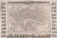
PLAN OF LONDON FROM AN ACTUAL SURVEY 233
This map was issued as a free supplementin the 'United Kingdom' newspaper.Surrounded by a decorative border, the map's title appears in a panel above the plan, with the arms of London, the royal family and the City of Westminster.Inset within the border areillustrations of prominent buildings and landmarks, including the Bank of England, Lambeth Palace, Covent Garden and Waterloo Bridge. The map shows the intended tunnel under the Thames linking Wapping and RotherhitheWhen, the firstunderwater tunnel in the world when it opened in 1843. Shury, John