Maps of West Dorset

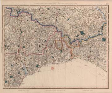
Cary's Improved Map of England and Wales
Cary, George, & Cary, John London : G. & J. Cary
Taunton and Lyme Regis - OS One-Inch Map
1 : 63360 Topographic maps Ordnance Survey Ordnance Survey
Dorset Shire, 1
2 Blätter : 109 x 54 cm s.n.
Exeter - OS One-Inch Map
1 : 63360 Topographic maps Ordnance Survey Ordnance Survey
Wellington (Outline) - OS One-Inch Revised New Series
1 : 63360 Topographic maps Ordnance Survey Ordnance Survey
Wellington (Hills) - OS One-Inch Revised New Series
1 : 63360 Topographic maps Ordnance Survey Ordnance Survey
Sidmouth (Outline) - OS One-Inch Revised New Series
1 : 63360 Topographic maps Ordnance Survey Ordnance Survey
Sidmouth (Hills) - OS One-Inch Revised New Series
1 : 63360 Topographic maps Ordnance Survey Ordnance Survey
South Petherton
Observation stations outside the boundaries of the landmass are indicated by red dots within pencil circles., These stations were used,to plot prominent features of an area being mapped -,such as church spires - in order to construct a grid., A red line thus -..-..-..- indicates the boundary between counties Somerset and Dorset., On the back of the manuscript is a note confirming T Budgen as draughtsman. Budgen, Thomas
Exmouth
This plan of the area around the mouth of the River Exe is comprised of two sheets joined together. The meticulous detail of the survey extends to recording sandbanks and details of the river bed. Relief is indicated by interlining ('hachuring') and shading. Stippling and stripes distinguish different land usage. A faint blue line with a quartered circle extending into Holcombe Down, at centre bottom, is probably an observation or measuring line. Annotations in pencil record the scale and date of the survey. At the bottom-right edge, "Part of the Ordn[ance"] is written ink. Stanley, William
Tiverton, Devon
The Ordnance Survey drawings show a greater preoccupation with the lie of the land than earlier maps. Relative relief and natural cover were important considerations in the planning of military strategies. The heavy brushwork interlining ('hachuring') on this drawing makes many place names and details difficult to interpret. The Ex River is shown running through the area. Part of the river forms the county boundary between Devon and Somerset, shown here by a red dotted line.
Cullompton
The heavy colour washes used to depict relief make this plan difficult to interpret. These Ordnance Survey drawings show a greater preoccupation with the lie of the land than any previous maps - testimony to the military impetus of the project. Inclines are indicated by interlining ('hachuring'), with the summits left bare. The boundary of Devon and Somerset is shown by a red pecked line. A note in the margin of the paper provides a key to the plan's interpretation.
Taunton
This drawing covers an area around the border of Devon and Somerset. The boundary is indicated by a red pecked line, running for much of its distance along the River Yarte. In the lower right hand corner a red dot is labelled 'Prize Hill'. This indicates a point from which the surveyor took observations and measurements in order to plot topographical features of the area. Castle Neroche is indicated by dark brushwork interlining ('hachuring'). Situated between Buckland Down and Neroche Forest, this was a 12th-century castle in the motte and bailey style - a central residential garrison with a raised keep alongside for defensive purposes.
Exeter (Hills) - OS One-Inch Revised New Series
1 : 63360 Topographic maps Ordnance Survey Ordnance Survey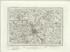
Exeter (Outline) - OS One-Inch Revised New Series
1 : 63360 Topographic maps Ordnance Survey Ordnance Survey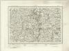
Tiverton (Outline) - OS One-Inch Revised New Series
1 : 63360 Topographic maps Ordnance Survey Ordnance Survey
Tiverton (Hills) - OS One-Inch Revised New Series
1 : 63360 Topographic maps Ordnance Survey Ordnance Survey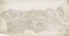
Beaminster
This drawing delineates the county borders of Dorset and Somerset with a red pecked line. Pillesdon Pen, a hillfort, is indicated by concentric rings to the left of the plan, although it did not become obligatory to record archaeological sites until 1816. The fort's position, 909 ft above sea level, is depicted by dark shading and brushwork interlining ('hachuring'). The summits of hills in this undulating countryside are left bare.
Bridport (Hills) - OS One-Inch Revised New Series
1 : 63360 Topographic maps Ordnance Survey Ordnance Survey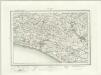
Bridport (Outline) - OS One-Inch Revised New Series
1 : 63360 Topographic maps Ordnance Survey Ordnance Survey
Yeovil (Hills) - OS One-Inch Revised New Series
1 : 63360 Topographic maps Ordnance Survey Ordnance Survey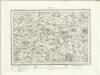
Yeovil (Outline) - OS One-Inch Revised New Series
1 : 63360 Topographic maps Ordnance Survey Ordnance Survey
Otterton (Outline) - OS One-Inch Revised New Series
1 : 63360 Topographic maps Ordnance Survey Ordnance Survey
Otterton (Hills) - OS One-Inch Revised New Series
1 : 63360 Topographic maps Ordnance Survey Ordnance Survey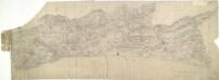
Bridport
The long stretch of sand in this plan is Chesil Beach. Once linked to Spain by well- established trade routes, it is also locally famed for reported sightings of the fabled Veasta Sea Monster. Signal points are marked along coast leading down to the beach, the most notable being Abbotsbury Castle Signal Staff on Abbotsbury Common. Pencil script records the date of execution and scale of the drawing. The words "Exhibit A" are written in blue pencil at the very edge of the sheet. A reference to the village of 'Wyke' (Wyke Regis) can be seen at the far right of the drawing. Budgen, Charles
Teignmouth (Hills) - OS One-Inch Revised New Series
1 : 63360 Topographic maps Ordnance Survey Ordnance Survey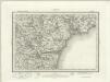
Teignmouth (Outline) - OS One-Inch Revised New Series
1 : 63360 Topographic maps Ordnance Survey Ordnance Survey
West Fleet (Hills) - OS One-Inch Revised New Series
1 : 63360 Topographic maps Ordnance Survey Ordnance Survey
West Fleet (Outline) - OS One-Inch Revised New Series
1 : 63360 Topographic maps Ordnance Survey Ordnance Survey