Maps of Sandown

A Plan of Sandham Fort in the Isle of Wight
Coloured view of Sandown Fort not Sandham as the title suggests) and the surrounding area. The fort which is sometimes known as Granite fort’, was built in 1862 to house eighteen, nine inch. It was situated close to the beach in the centre of Sandown Bay, on a rock eighteen feet above sea level. Originally it houses eighteen nine inch guns however it was felt that conditions were too cramped and some of these were replaced with smaller guns. Additional fortifications were built at Yaverland, Sandown Banks and Redcliff to support Sandown Fort. The fort was sold in the 1930s and a Zoo was established on the site.
Hampshire and Isle of Wight XCVI.14 (includes: Brading; Sandown Shanklin) - 25 Inch Map
1 : 2500 Topographic maps Ordnance Survey Ordnance Survey
Hampshire & Isle of Wight XCVI.SW - OS Six-Inch Map
1 : 10560 Topographic maps Ordnance Survey Ordnance Survey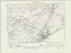
Hampshire & Isle of Wight XCVI.SW - OS Six-Inch Map
1 : 10560 Topographic maps Ordnance Survey Ordnance Survey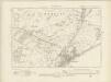
Hampshire & Isle of Wight XCVI.SW - OS Six-Inch Map
1 : 10560 Topographic maps Ordnance Survey Ordnance Survey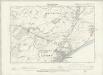
Hampshire & Isle of Wight XCVI.SW - OS Six-Inch Map
1 : 10560 Topographic maps Ordnance Survey Ordnance Survey
Hampshire & Isle of Wight XCVI - OS Six-Inch Map
1 : 10560 Topographic maps Ordnance Survey Ordnance Survey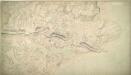
St Helens 27A
1 : 10560 This plan of the Isle of Wight extends from Sandown Bay, At the bottom right, To Haven Street, At the top. The drawing is made on rectangular sheet lines, Enclosed by a black border. Fields are coloured brown where cultivated, And green or blank if untilled. Stonework buildings or structures are drawn in red ink at major settlements like Newchurch and Brading. Infilled or blocked areas of black or sepia ink depict structures or buildings made from impermanent materials such as wood. Coniferous trees are distinguished pictorially from deciduous trees on this map. Gardner, William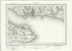
Portsmouth (Outline) - OS One-Inch Revised New Series
1 : 63360 Topographic maps Ordnance Survey Ordnance Survey
Portsmouth (Hills) - OS One-Inch Revised New Series
1 : 63360 Topographic maps Ordnance Survey Ordnance Survey
Map of the Isle of Wight
1 : 78000 Isle of Wight (Anglie) Edward Stanford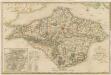

Bacon's new map of the Isle of Wight
1 : 63360 G.W. Bacon & Co.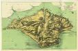
Wight[The Isle of]
Fowles, A.W. Ventnor
Map of Hampshire, including the Isle of Wight, 6
1 Blatt : 52 x 69 cm s.n.
V anglickém průlivu


O anglickém průlivu
1 : 290000 Isle of Wight (Anglie) Hanf, Norbert Kořenský, Josef J. Otta
Wight Vectis olim [Karte], in: Gerardi Mercatoris Atlas, sive, Cosmographicae meditationes de fabrica mundi et fabricati figura, S. 130.
1 Karte aus Atlas Mercator, Gerhard Montanus, Petrus
VECTIS | INSVLA. | Anglice | THE ISLE OF | WIGHT.
[Amsterdam : Joan Blaeu]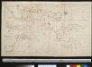
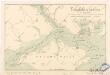
Nieuwe afteekening van de reede van Portsmouth, Spithead en St. Hellens Road aen de Oost zijde vant eijland Wight in het Kanaal
England Johannes van Keulen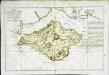
Essai d'une isle de Wight
1 Karte : Kupferdruck ; 30 x 47 cm Le Rouge; Taylor chez le Rouge rue des g.ds Augustins
Vectis Insula. Anglice The Isle Of Wight. [Karte], in: Theatrum orbis terrarum, sive, Atlas novus, Bd. 4, S. 183.
1 Karte aus Atlas Blaeu, Joan Blaeu, Willem Janszoon
Vectis Insula. Anglice The Isle Of Wight. [Karte], in: Theatrum orbis terrarum, sive, Atlas novus, Bd. 4, S. 183.
1 Karte aus Atlas Blaeu, Joan Blaeu, Willem Janszoon
Vectis insvla. anglice the isle of Wight
1 Karte : Kupferdruck ; 37 x 49 cm Blaeu Joan Blaeu
Nieuwe afteekening van de reede van Portsmouth, Spithead en St. Hellens Road aen de Oost zijde vant eijland Wight in het Kanaal
England Gerard van Keulen
Vectis Insula. Anglice The Isle Of Wight. [Karte], in: Le théâtre du monde, ou, Nouvel atlas contenant les chartes et descriptions de tous les païs de la terre, Bd. 4, S. 161.
1 Karte aus Atlas Blaeu, Willem Janszoon und Blaeu, Joan Blaeu, Willem Janszoon
Description of the Isle of Wight
This map of the Isle of Wight dates from around 1600. It is titled on the reverse "Description of the Isle of Wight". A scale bar is included with the motif of dividers, stating ‘Scala Miliaria’, revealing that the map is drawn on a scale of half an inch to one mile. We can not be certain of the identity of the cartographer of this map but it may be one which is thought to have been produced by William White, which was then augmented and published by John Speed in his Theatre of the Empire of Great Britaine. Both this map and the Speed map exaggerate the width of waterways, the depth of bays and prominence of headlands, in a similar way. Such exaggerations suggest that this map was not the result of survey and was drawn by eye. The beacon network on the island is shown by pictorial representations of individual beacons. The Needles are represented by three squat triangles and labelled ‘The nedles’. The period during which this map was produced saw England at war with Spain. The emphasis on the beacon network suggests that the map is concerned with defence in this climate of unease. Since the accession of the Protestant Elizabeth I to the English throne in 1558 Anglo-Spanish relationship had deteriorated. The continued English raids on Spanish colonial interests and England’s support of the Protestant rebellion in the Spanish ruled Netherlands had induced the Catholic Philip II to plan an invasion of England. Although the Spanish were dramatically defeated by the English in 1588, England remained at war with Spain for many years and further attempts to invade were made by Philip of Spain with the dispersal of the ‘second Armada’ in October 1596 and the assembly of the ‘third Armada’ in the following spring. White, William


