Maps of Warwickshire
Hinckley
1 : 31680 This plan covers Leicestershire and,a,part of Warwickshire at bottom left. The Watling Street,,an ancient Roman road from London to Wroxeter, via St. Albans and Leicester, forms the lower boundary of the plan., Stevens, Henry
Leicestershire XXXV.11 (includes: Higham on the Hill; Hinckley; Peckleton; Sutton Cheney) - 25 Inch Map
1 : 2500 Topographic maps Ordnance Survey Ordnance Survey
Leicestershire XXXV.11 (includes: Higham on the Hill; Hinckley; Peckleton; Sutton Cheney) - 25 Inch Map
1 : 2500 Topographic maps Ordnance Survey Ordnance Survey
Leicestershire XXXV.11 (includes: Higham on the Hill; Hinckley; Peckleton; Sutton Cheney) - 25 Inch Map
1 : 2500 Topographic maps Ordnance Survey Ordnance Survey
Leicestershire XXXV.15 (includes: Higham on the Hill; Hinckley; Sutton Cheney) - 25 Inch Map
1 : 2500 Topographic maps Ordnance Survey Ordnance Survey
Leicestershire XXXV.15 (includes: Higham on the Hill; Hinckley; Sutton Cheney) - 25 Inch Map
1 : 2500 Topographic maps Ordnance Survey Ordnance Survey
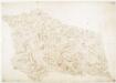
Leicestershire XXXV.SE - OS Six-Inch Map
1 : 10560 Topographic maps Ordnance Survey Ordnance Survey
Leicestershire XXXV.SE - OS Six-Inch Map
1 : 10560 Topographic maps Ordnance Survey Ordnance Survey
Leicestershire XXXV.SE - OS Six-Inch Map
1 : 10560 Topographic maps Ordnance Survey Ordnance Survey
Leicestershire XXXV.SE - OS Six-Inch Map
1 : 10560 Topographic maps Ordnance Survey Ordnance Survey
Leicestershire XXXV.SW - OS Six-Inch Map
1 : 10560 Topographic maps Ordnance Survey Ordnance Survey
Leicestershire XXXV.SW - OS Six-Inch Map
1 : 10560 Topographic maps Ordnance Survey Ordnance Survey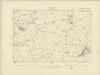
Leicestershire XXXV.SW - OS Six-Inch Map
1 : 10560 Topographic maps Ordnance Survey Ordnance Survey
Leicestershire XXXV.14 (includes: Higham on the Hill; Hinckley; Sheepy) - 25 Inch Map
1 : 2500 Topographic maps Ordnance Survey Ordnance Survey
Leicestershire XXXV.14 (includes: Higham on the Hill; Hinckley; Sheepy) - 25 Inch Map
1 : 2500 Topographic maps Ordnance Survey Ordnance Survey
Leicestershire XXXV.10 (includes: Higham on the Hill; Hinckley; Sheepy; Sutton Cheney) - 25 Inch Map
1 : 2500 Topographic maps Ordnance Survey Ordnance Survey
Leicestershire XXXV.10 (includes: Higham on the Hill; Hinckley; Sheepy; Sutton Cheney) - 25 Inch Map
1 : 2500 Topographic maps Ordnance Survey Ordnance Survey
Leicestershire XXXV.10 (includes: Higham on the Hill; Hinckley; Sheepy; Sutton Cheney) - 25 Inch Map
1 : 2500 Topographic maps Ordnance Survey Ordnance Survey
SP49 - OS 1:25,000 Provisional Series Map
1 : 25000 Topographic maps Ordnance Survey Ordnance Survey
Leicestershire XXXV.7 (includes: Sutton Cheney) - 25 Inch Map
1 : 2500 Topographic maps Ordnance Survey Ordnance Survey
Leicestershire XXXV.7 (includes: Sutton Cheney) - 25 Inch Map
1 : 2500 Topographic maps Ordnance Survey Ordnance Survey
Leicestershire XXXV.7 (includes: Sutton Cheney) - 25 Inch Map
1 : 2500 Topographic maps Ordnance Survey Ordnance Survey
Coventry and Rugby - OS One-Inch Map
1 : 63360 Topographic maps Ordnance Survey Ordnance Survey
Burton upon Trent - OS One-Inch Map
1 : 63360 Topographic maps Ordnance Survey Ordnance Survey
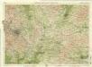
Derby and Leicester - OS One-Inch Map
1 : 63360 Topographic maps Ordnance Survey Ordnance Survey
The counti of Warwick the shire towne and citie of Coventre described
1 : 1
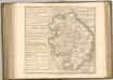
Leicestrensis comitatvs
1 Karte : Kupferdruck ; 37 x 48 cm Blaeu Joan Blaeu
Leicestrensis Comitatus cum Rutlandiae vulgo Leicester & Rutland Shire
1 : 160000 Amstelodami : ex. Joannes Janssonius