Maps of Enfield

Chipping Barnet
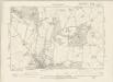
1 : 31680 The most obvious features of this plan are major roads coloured yellow, with their cumulative lengths noted at intervals of one mile. North is not orientated towards the top. As a result,Watford appears to the left of St Albans, and the boundary between Middlesex and Hertfordshire (a dashed black-ink line)runs from the top left of the map down through Elstree to Hadley. The paper carries a watermark from the James Whatman Turkey Mill. Hyett, William
A topographical map of Hartford-Shire, 8
1 Blatt : 53 x 72 cm A. Dury
North London (Hills) - OS One-Inch Revised New Series
1 : 63360 Topographic maps Ordnance Survey Ordnance Survey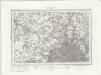
North London (Outline) - OS One-Inch Revised New Series
1 : 63360 Topographic maps Ordnance Survey Ordnance Survey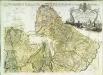
Carte topographique de le comté de Middlesex, 2
1 Blatt : 53 x 73 cm John Rocque
TL20 - OS 1:25,000 Provisional Series Map
1 : 25000 Topographic maps Ordnance Survey Ordnance Survey
TQ29 - OS 1:25,000 Provisional Series Map
1 : 25000 Topographic maps Ordnance Survey Ordnance Survey
TL10 - OS 1:25,000 Provisional Series Map
1 : 25000 Topographic maps Ordnance Survey Ordnance Survey
TQ19 - OS 1:25,000 Provisional Series Map
1 : 25000 Topographic maps Ordnance Survey Ordnance Survey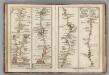
London to Highgate & Hampstead to Hendon, London to St. Albans.
1 : 63360 Cary, John
Buckinghamshire XLIX - OS Six-Inch Map
1 : 10560 Topographic maps Ordnance Survey Ordnance Survey
Hertfordshire XXXIV - OS Six-Inch Map
1 : 10560 Topographic maps Ordnance Survey Ordnance Survey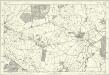
Hertfordshire XXXIX - OS Six-Inch Map
1 : 10560 Topographic maps Ordnance Survey Ordnance Survey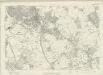
London Sheet A - OS Six-Inch Map
1 : 10560 Topographic maps Ordnance Survey Ordnance Survey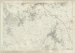
Middlesex X - OS Six-Inch Map
1 : 10560 Topographic maps Ordnance Survey Ordnance Survey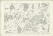
Hertfordshire XXXV - OS Six-Inch Map
1 : 10560 Topographic maps Ordnance Survey Ordnance Survey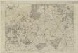
Middlesex I - OS Six-Inch Map
1 : 10560 Topographic maps Ordnance Survey Ordnance Survey
London Sheet B - OS Six-Inch Map
1 : 10560 Topographic maps Ordnance Survey Ordnance Survey
Middlesex VI - OS Six-Inch Map
1 : 10560 Topographic maps Ordnance Survey Ordnance Survey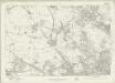
London Sheet F - OS Six-Inch Map
1 : 10560 Topographic maps Ordnance Survey Ordnance Survey
Middlesex XI - OS Six-Inch Map
1 : 10560 Topographic maps Ordnance Survey Ordnance Survey
TL00 - OS 1:25,000 Provisional Series Map
1 : 25000 Topographic maps Ordnance Survey Ordnance Survey
TQ09 - OS 1:25,000 Provisional Series Map
1 : 25000 Topographic maps Ordnance Survey Ordnance Survey
TQ18 - OS 1:25,000 Provisional Series Map
1 : 25000 Topographic maps Ordnance Survey Ordnance Survey
TQ28 - OS 1:25,000 Provisional Series Map
1 : 25000 Topographic maps Ordnance Survey Ordnance Survey
Detail from OSD 152 (Hampstead)
1 : 31680 The individual settlements that make up this area of London are shown by red blocks, with boundary lines indicating the fields separating them. Shading and soft interlining indicate relief, neatly illustrated at Primrose Hill, the summit of which is left bare. The barracks at the edge of Hyde Park are illustrated at the very bottom of the map. The dark blue-black line running from West Drayton to Brentford and Paddington is the Grand Junction Canal. This was London's principal link to the rest of Britain's canals, allowing the passage of goods to and from the industrial towns of the North and Midlands. Hyett includes a ground plan of Kenwood House in Hampstead, showing a level of detail much greater than might be expected from a map with a scale of two inches-to-the-mile. Hyett, William
Harrison's Bicycle Road Map of Middlesex.
E.Harrison
Map of the Country twelve miles round London. Engraved by W.R. Gardner.
Buckinghamshire XLIX.SW - OS Six-Inch Map
1 : 10560 Topographic maps Ordnance Survey Ordnance Survey
Buckinghamshire LIV.NW - OS Six-Inch Map
1 : 10560 Topographic maps Ordnance Survey Ordnance Survey