Maps of Tandridge

Croydon
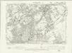
1 : 31680 Woodland and agricultural land dominate this plan, which covers an area from Beckenham and Croydon at the top, to Felbridge, Hackenham and Gotwick at the bottom. Buildings are infilled and blocked together at Croydon, the largest settlement shown.
A topographical-map, of the county of Kent, 6
1 Blatt : 54 x 69 cm s.n.
TQ45 - OS 1:25,000 Provisional Series Map
1 : 25000 Topographic maps Ordnance Survey Ordnance Survey
TQ44 - OS 1:25,000 Provisional Series Map
1 : 25000 Topographic maps Ordnance Survey Ordnance Survey
TQ35 - OS 1:25,000 Provisional Series Map
1 : 25000 Topographic maps Ordnance Survey Ordnance Survey
TQ34 - OS 1:25,000 Provisional Series Map
1 : 25000 Topographic maps Ordnance Survey Ordnance Survey
TQ46 - OS 1:25,000 Provisional Series Map
1 : 25000 Topographic maps Ordnance Survey Ordnance Survey
TQ36 - OS 1:25,000 Provisional Series Map
1 : 25000 Topographic maps Ordnance Survey Ordnance Survey
Kent XV - OS Six-Inch Map
1 : 10560 Topographic maps Ordnance Survey Ordnance Survey
Kent XXVII - OS Six-Inch Map
1 : 10560 Topographic maps Ordnance Survey Ordnance Survey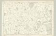
Surrey XXI - OS Six-Inch Map
1 : 10560 Topographic maps Ordnance Survey Ordnance Survey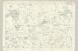
Surrey XXVIII - OS Six-Inch Map
1 : 10560 Topographic maps Ordnance Survey Ordnance Survey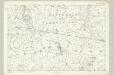
Surrey XXXVI - OS Six-Inch Map
1 : 10560 Topographic maps Ordnance Survey Ordnance Survey
Surrey XIV - OS Six-Inch Map
1 : 10560 Topographic maps Ordnance Survey Ordnance Survey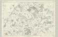
Surrey XX - OS Six-Inch Map
1 : 10560 Topographic maps Ordnance Survey Ordnance Survey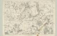
Surrey XXVII - OS Six-Inch Map
1 : 10560 Topographic maps Ordnance Survey Ordnance Survey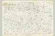
Surrey XXXV - OS Six-Inch Map
1 : 10560 Topographic maps Ordnance Survey Ordnance Survey
Kent XVI - OS Six-Inch Map
1 : 10560 Topographic maps Ordnance Survey Ordnance Survey
Kent XXVIII - OS Six-Inch Map
1 : 10560 Topographic maps Ordnance Survey Ordnance Survey
Kent XXXIX - OS Six-Inch Map
1 : 10560 Topographic maps Ordnance Survey Ordnance Survey
Kent XLIX - OS Six-Inch Map
1 : 10560 Topographic maps Ordnance Survey Ordnance Survey
Surrey XLII - OS Six-Inch Map
1 : 10560 Topographic maps Ordnance Survey Ordnance Survey
Penshurst (Kent)
1 : 21120 Drawing showing the area to the west of Penshurst in Kent. The lack of hill sketching suggests this is an intermediate version rather than a completed drawing. Woodland is indicated by meticulous renderings of individual trees. Stone walls, indicated in red ink, mark field boundaries. A pest house ("Pest Ho") is noted to the left of Sevenoaks Common. The pest house provided shelter for people afflicted by plague and other infectious diseases at a safe distance from the densely populated town.
Surrey XLIII - OS Six-Inch Map
1 : 10560 Topographic maps Ordnance Survey Ordnance Survey
A topographical-map, of the county of Kent, 11
1 Blatt : 54 x 69 cm A. Dury, W. Herbert
Kent LIX - OS Six-Inch Map
1 : 10560 Topographic maps Ordnance Survey Ordnance Survey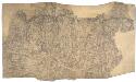
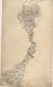
Sevenoaks (Kent)
1 : 21120 Drawing showing the area to the southwest of Sevenoaks. A note in the bottom right corner confirms that this is a field sketch. The loose drawing style contrasts greatly with the later, more finished drawings.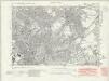
Kent XV.NW - OS Six-Inch Map
1 : 10560 Topographic maps Ordnance Survey Ordnance Survey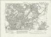
Kent XV.NW - OS Six-Inch Map
1 : 10560 Topographic maps Ordnance Survey Ordnance Survey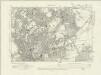
Kent XV.NW - OS Six-Inch Map
1 : 10560 Topographic maps Ordnance Survey Ordnance Survey