Maps of Eastling

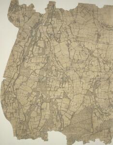
Eastling, Kent 6
Drawing showing the area around Eastling in Kent. This is an 'outline drawing'. It is uncoloured and has no representation of relative relief. Such drawings represented the halfway stage between the original protraction and the finished darwing. Increasingly sophisticated mapmaking techniques made this intermediate stage redundant by the 1830s. Red lines also feature heavily. Radiating from fixed points, these show the angular measurements taken with a theodolite to enable the surveryor to plot the location of topographical features. Black lines indicate the edges of the area intended to be copied up for the finished drawing. Pink, George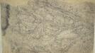
Challock, Kent
1 : 10560 This pencil and ink drawing is a very rough sketch or 'foul plan' of a rural section of the North Downs in Kent. It was drawn on 17 pieces of irregularly cut paper. The map was made in the field by the draughtsman to augment the angle and distance measurements noted in his field books. The detail recorded here was incorporated into the 'fair' drawing, which survives as OSD 109/110/111, serial 380. Pink, George
TQ95 - OS 1:25,000 Provisional Series Map
1 : 25000 Topographic maps Ordnance Survey Ordnance Survey
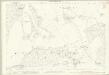
Eastling, Kent 27A
1 : 10560 This plan of the east Kent lowlands shows a region characterised by irregularly shaped field boundaries. The drawing is made on rectangular sheet lines, enclosed by a black border. Fields are coloured brown where cultivated, and green or blank if untilled. Stonework buildings or structures are drawn in red ink at the settlements of Eastling and Moldash. Infilled or blocked areas of black or sepia ink denote structures or buildings made from less permanent materials such as wood.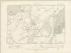
Kent XLIV.NE - OS Six-Inch Map
1 : 10560 Topographic maps Ordnance Survey Ordnance Survey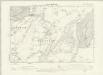
Kent XLIV.NE - OS Six-Inch Map
1 : 10560 Topographic maps Ordnance Survey Ordnance Survey
Kent XLIV.SE - OS Six-Inch Map
1 : 10560 Topographic maps Ordnance Survey Ordnance Survey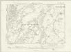
Kent XLIV.SE - OS Six-Inch Map
1 : 10560 Topographic maps Ordnance Survey Ordnance Survey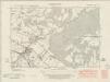
Kent LIV.NE - OS Six-Inch Map
1 : 10560 Topographic maps Ordnance Survey Ordnance Survey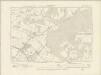
Kent LIV.NE - OS Six-Inch Map
1 : 10560 Topographic maps Ordnance Survey Ordnance Survey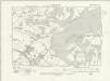
Kent LIV.NE - OS Six-Inch Map
1 : 10560 Topographic maps Ordnance Survey Ordnance Survey
Kent LIV.NE - OS Six-Inch Map
1 : 10560 Topographic maps Ordnance Survey Ordnance Survey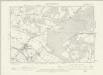
Kent LIV.NE - OS Six-Inch Map
1 : 10560 Topographic maps Ordnance Survey Ordnance Survey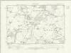
Kent XLV.SW - OS Six-Inch Map
1 : 10560 Topographic maps Ordnance Survey Ordnance Survey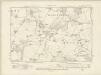
Kent XLV.SW - OS Six-Inch Map
1 : 10560 Topographic maps Ordnance Survey Ordnance Survey
Kent XLV.SW - OS Six-Inch Map
1 : 10560 Topographic maps Ordnance Survey Ordnance Survey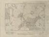
Kent XLV.NW - OS Six-Inch Map
1 : 10560 Topographic maps Ordnance Survey Ordnance Survey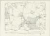
Kent XLV.NW - OS Six-Inch Map
1 : 10560 Topographic maps Ordnance Survey Ordnance Survey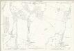
Kent XLV.1 (includes: Ospringe; Sheldwich; Throwley) - 25 Inch Map
1 : 2500 Topographic maps Ordnance Survey Ordnance Survey
Kent XLV.1 (includes: Ospringe; Sheldwich; Throwley) - 25 Inch Map
1 : 2500 Topographic maps Ordnance Survey Ordnance Survey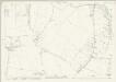
Kent XLV.5 (includes: Leaveland; Sheldwich; Throwley) - 25 Inch Map
1 : 2500 Topographic maps Ordnance Survey Ordnance Survey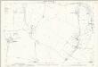
Kent XLV.5 (includes: Leaveland; Sheldwich; Throwley) - 25 Inch Map
1 : 2500 Topographic maps Ordnance Survey Ordnance Survey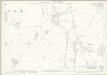
Kent XLV.9 (includes: Badlesmere; Leaveland; Throwley) - 25 Inch Map
1 : 2500 Topographic maps Ordnance Survey Ordnance Survey
Kent XLV.9 (includes: Badlesmere; Leaveland; Throwley) - 25 Inch Map
1 : 2500 Topographic maps Ordnance Survey Ordnance Survey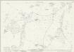
Kent XLV.13 (includes: Badlesmere; Challock; Leaveland; Molash; Throwley) - 25 Inch Map
1 : 2500 Topographic maps Ordnance Survey Ordnance Survey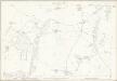
Kent XLV.13 (includes: Badlesmere; Challock; Leaveland; Molash; Throwley) - 25 Inch Map
1 : 2500 Topographic maps Ordnance Survey Ordnance Survey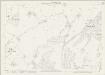
Kent XLIV.4 (includes: Eastling; Ospringe; Throwley) - 25 Inch Map
1 : 2500 Topographic maps Ordnance Survey Ordnance Survey
Kent XLIV.4 (includes: Eastling; Ospringe; Throwley) - 25 Inch Map
1 : 2500 Topographic maps Ordnance Survey Ordnance Survey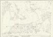
Kent LV.1 (includes: Challock; Wye) - 25 Inch Map
1 : 2500 Topographic maps Ordnance Survey Ordnance Survey