Maps of Highland

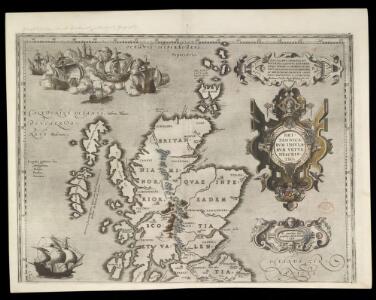
BRITANNICARUM INSULARUM VETUS DESCRIPTIO - Scotland
This map of the British Isles is the work of Abraham Ortelius. It dates from 1590 and was published in Antwerp. It appears in the forth Additamentum to Ortelius's Theatrum Orbis Terrarum. Ortelius published these 'additions' to supplement editions of his atlas. The fourth Additamentum contained, in addition to new, more modern maps, a section devoted to classical history known as the Parergon. It is in this section that this map resides. Here the northern and southern parts of the British Isles are shown with British tribes, Roman town names and other information according to classical traditions. For this new map Ortelius has based the outline of England and Wales on that of Christopher Saxton, which portrayed the proportions of the land mass more accurately than before, with Ireland and Scotland remaining the same as the existing maps in the atlas. It is likely that the engraving was by Jan Wierix. Ortelius, Abraham
Britain in the Dark Ages
1 : 1000000 Velká Británie Ordnance Survey of the Great Britain
Scotia antiqva
2 Karten auf 1 Blatt : Kupferdruck ; Bildgrösse 42 x 54 cm Blaeu; Gordon Joan Blaeu
Scotia Regnum. [Karte], in: Gerardi Mercatoris Atlas, sive, Cosmographicae meditationes de fabrica mundi et fabricati figura, S. 100.
1 Karte aus Atlas Mercator, Gerhard Montanus, Petrus
Partie, l'Angleterre. Europe 7.
1 : 1641836 Vandermaelen, Philippe, 1795-1869
Composite: Scotland.
1 : 450000 Robert Laurie & James Whittle

Carte de l'Ecosse
1 : 1950000 Skotsko Bonne, Rigobert André
New and correct map of Scotland & the Isles.
1 : 2100000 Moll, Herman, d. 1732
Scotland
1 : 1370000 Skotsko Weiland, Karl Ferdinand Maedel, Carl Jos. Geograph. Institut
Composite: Scotland.
1 : 500000 Cary, John, ca. 1754-1835
Scotland or N. Britain.
1 : 1500000 Bowen, Emanuel
Scotland.
1 : 1350000 Weiland, C. F. (Carl Ferdinand), d. 1847
Scotland.
1 : 3000000 Seaman, James V.
[Schotland mit der Nördlichen Spitze von England]
Hand-Atlas über alle Theile der Erde nach dem neuesten Zustande und über das Weltgebäude Stieler, Adolf bei Justus Perthes
Isles britanniques
1 Karte : Kupferdruck ; 31 x 42 cm Mentelle; Tardieu; André Mentelle
Scotia, Regnum. [Karte], in: Atlas, sive, Cosmographicae meditationes de fabrica mundi et fabricati figura, S. 83.
1 Karte aus Atlas Mercator, Gerhard
Carte des Iles Britanniques.
1 : 2600000 Vivien de St Martin, L.

Carte physique et routiere de l'Ecosse
1 : 1500000 Skotsko Starling, Thomas Virtue, George George Virtue
Scotland.
1 : 1550000 Lavoisne, M.
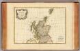
Ecosse.
1 : 1740000 Migeon, J.
Karte von Scotland
1 : 900000 Skotsko Dorret, J. Schraembl, Franz Anton F.A. Schraembl
Karte von Scotland
1 : 900000 Skotsko Dorret, J. Schraembl, Franz Anton F.A. Schraembl
Grossbritannien. Nordliches Blatt: Schottland U. Der Nordlichste Theil England's.
1 : 1500000 Petermann, A.
Schotland.
1 : 1550000 Radefeld, Carl Christian Franz, 1788-1874
Scotland.
1 : 2100000 Darton, William
Palaeontological Map of the British Islands
The physical atlas Johnston, Alexander Keith William Blackwood & Sons
Scotland.
1 : 2400000 Bowen, Frances