Maps of Carlisle

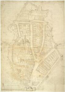
The Citie off Carlesle
This is a plan of the city of Carlisle which may date from 1563. It has been drawn to scale with drawings of landmark features superimposed, such as the church and castle which dominates the city. During the period 1173-1461 the castle was attacked nine times and the building fell into disrepair. It is possible that this plan was drawn in 1563 to show the need for repairs to be made to the castle walls that extend around the town and appear to be damaged in several areas. As with many Tudor town plans, the pillory in the market place is prominently drawn. A scale bar in included in the lower left hand corner: Every inch conteyneth one hundreth Feete’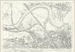
Cumberland XXIII.3 (includes: Carlisle) - 25 Inch Map
1 : 2500 Topographic maps Ordnance Survey Ordnance Survey
Cumberland XXIII.3 (includes: Carlisle) - 25 Inch Map
1 : 2500 Topographic maps Ordnance Survey Ordnance Survey
Cumberland XXIII.3 (includes: Carlisle) - 25 Inch Map
1 : 2500 Topographic maps Ordnance Survey Ordnance Survey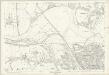
Cumberland XXIII.3 (includes: Carlisle) - 25 Inch Map
1 : 2500 Topographic maps Ordnance Survey Ordnance Survey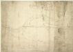
A Chart Showing the Course of the River Eden near Carlisle and of a Breach Neccessary to be Repaired, a platt of certen grounde about Carleile, for demonstration of a breech of the river of Eaden, Jan. 1572
This manuscript plan of the Carlisle area dates from 1572-73. Its purpose seems to be to demonstrate a breech of the river Eaden that is in need of repair. The point where this repair is necessary is highlighted by a pointing hand. Carlisle is shown as a walled city in a pictorial fashion typical of Tudor map makers. North, East and west are indicated on the plan, as is the way to Scotland.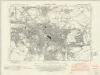
Cumberland XXIII.NE - OS Six-Inch Map
1 : 10560 Topographic maps Ordnance Survey Ordnance Survey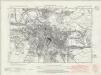
Cumberland XXIII.NE - OS Six-Inch Map
1 : 10560 Topographic maps Ordnance Survey Ordnance Survey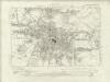
Cumberland XXIII.NE - OS Six-Inch Map
1 : 10560 Topographic maps Ordnance Survey Ordnance Survey
Cumberland XXIII.NE - OS Six-Inch Map
1 : 10560 Topographic maps Ordnance Survey Ordnance Survey
Cumberland XXIII - OS Six-Inch Map
1 : 10560 Topographic maps Ordnance Survey Ordnance Survey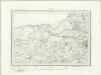
Carlisle (Outline) - OS One-Inch Revised New Series
1 : 63360 Topographic maps Ordnance Survey Ordnance Survey
Carlisle (Hills) - OS One-Inch Revised New Series
1 : 63360 Topographic maps Ordnance Survey Ordnance Survey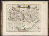
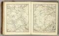
Annandiae praefectura, Vulgo, The Stewartrie of Annandail / auct. Timotheo Pont ; excud. I. Blaeu.
Pont, Timothy, 1560?-1614? Blaeu, Joan, 1596-1673
ANNANDIÆ Præfectura, | Vulgo | THE STEWARTRIE of ANNANDAIL.
Auct. Timotheo Pont. Excud. Io. Blaeu.
Annandiæ præfectura, vulgo the stewartrie of Annandail
1 Karte : Kupferdruck ; 41 x 49 cm Blaeu; Pont Joan Blaeu
Carlisle - OS One-Inch Map
1 : 63360 Topographic maps Ordnance Survey Ordnance Survey
Solway - Bartholomew's 'Survey Atlas of Scotland'
1 : 126720 Topographic maps John Bartholomew & Son, Ltd John Bartholomew & Son, Ltd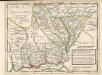
Anandale : is Part of Dumfreis Shire. Eusdale or Eskdale and Liddesdale is the South Part of Roxburgh Sh. / H. Moll.
Moll, Herman, d. 1732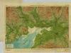
Solway, Sheet 2 - Bartholomew's "Half Inch to the Mile Maps" of Scotland
1 : 126720 Topographic maps John Bartholomew & Son, Ltd John Bartholomew & Son, Ltd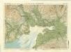
Solway District, Sheet 2 - Bartholomew's "Half Inch to the Mile Maps" of Scotland
1 : 126720 Topographic maps Bartholomew, John George John Bartholomew & Co
The Lake District, Sheet 3 - Bartholomew's "Half Inch to the Mile Maps" of England & Wales
1 : 126720 Topographic maps Bartholomew, John George John Bartholomew & Co
A Platt of the opposete Borders of Scotland to ye west marches of England
This is a map of the opposite borders of Scotland and England. It is from an atlas that belonged to William Cecil Lord Burghley, Elizabeth I’s Secretary of State. Burghley used this atlas to illustrate domestic matters. This map is interesting because it shows the debatable lands, these were lands between the borders of Scotland and England, claimed by neither and subsequently a lawless no-man’s land. Lord Burghley has annotated the map, adding place names at points along the river which forms part of the border, and the river immediately to the right of this which lies on English soil. The title, "A Platt of the opposete Borders of Scotland to ye west marches of England" appears on the reverse with the date:"Dec. 1590". There is a description on the map itself which ends: "for those on the English coast they ar referred to the tract latly sent to your L. of the description of them in particular". A scale bar of 4" - 10 [miles] is included. William Cecil, Lord Burghley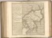
Sheets 66-67. (Cary's England, Wales, and Scotland).
1 : 360000 Cary, John, ca. 1754-1835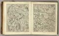
Sheets 58-59. (Cary's England, Wales, and Scotland).
1 : 360000 Cary, John, ca. 1754-1835
Cvmbria; vulgo Cvmberland
1 Karte : Kupferdruck ; 39 x 48 cm Blaeu Joan Blaeu
Comitatvs Northvmbria; vernacula Northvmberland
1 Karte : Kupferdruck ; 39 x 48 cm Blaeu Joan Blaeu
A new map of the counties of Cumberland and Westmoreland
1 Karte : Kupferdruck ; 66 x 50 cm Tinney; Bowles; Sayer; Bowles; Bowles printed for T. Bowles in St. Pauls Church Yard Rob.t Sayer and John Tinney in Fleet street and John Bowles and son in Cornhill