Maps of Alkham
Plan of Dover Harbour
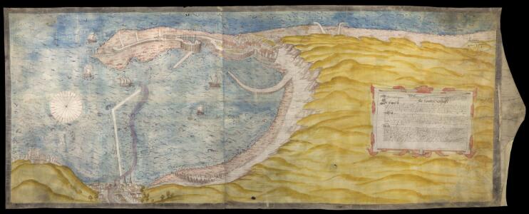
This is an anonymous plan of proposals for Dover harbour dating from 1552. It is titled 'ffor dovour pere. Thys platt exhibited vnto the kinges maiesties (?) most honorable pryvey counsell the xxiith daye of the monthe of november anno regis Edwardi Sexti sexto: de domini 1552. It is drawn and finished to a high standard, suggesting that it is a show plan intended for presentation. The map extends from Dover Castle to Folkestone. The surrounding area is shown schematically in yellow but is largely obscured by a large, pictorial cartouche containing an explanation of the proposals derived from a separate written statement. Dover Harbour is seen from an imaginary viewpoint to the north-east. The view of the town is considerable foreshortened. The sea is shown at high tide. South-West is at the top and there is a compass rose with North, South, East and West marked schematically with a crescent moon, sun, fleur-de-lys and star. The plan illustrates a variation on the proposals of 1541, shown in a map by Richard Cavendish, for the enclosure of Dover Harbour behind two immense piers stretching south from the old town and north, in this case, from Crane Head with further jetties envisaged to the south of the King's Pier and Archcliff ('Heckclyfe'). Outlines of the continuation of the pier from Crane Head are visible under the blue of the sea suggesting that there were intentions to continue on the shore side behind the pier from the North, but this idea seems to have been abandoned in the process of drawing the plan. The stylistic treatment of the depiction of the sea, the compass star, the land and the buildings, suggests that the draughtsman of this map is the same individual who created an anonymous Dover plan, convincingly dated about 1532 and is likely to have been by a painter rather than an engineer or surveyor. In contrast, this plan represents features of the harbour in a less artistic, more cartographic style. The proposed piers are shown in plan and not, as on the 1532 plan, as if completed. These developments in presentation may be a result of the presence of Sir Richard Lee, a regular visitor to Dover and probable draughtsman of a 1538 view of Dover and of a plan of Orwell Haven where the same presentation methods are employed.
Kent LXXVI.NW - OS Six-Inch Map
1 : 10560 Topographic maps Ordnance Survey Ordnance Survey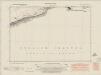
Kent LXXVI.NW - OS Six-Inch Map
1 : 10560 Topographic maps Ordnance Survey Ordnance Survey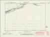
Kent LXXVI.NW - OS Six-Inch Map
1 : 10560 Topographic maps Ordnance Survey Ordnance Survey
Kent LXXVI.NW - OS Six-Inch Map
1 : 10560 Topographic maps Ordnance Survey Ordnance Survey
Kent LXXVI.NW - OS Six-Inch Map
1 : 10560 Topographic maps Ordnance Survey Ordnance Survey
Dover Havyn
This is a chart of Dover harbour, likely to be the work of Richard Cavendish. Drawn in inks and watercolour on parchment it depicts improvements to the town, castle and outlying buildings. It was produced by a commission created by Henry VIII in January 1541, who were to "be overseers of the water works at Dover and to procure materials and workmen for the same". It shows protective piers, enclosing almost half of the bay which are to prevent the build up of silt. There is no text to accompany the drawing except for the signatures of the commissioners of the project. In the left-hand margin are measurements in feet. It is thought that this is a show drawing, probably resulting from Henry VIII’s visit in March 1541 or May 1542. It reveals the state of the works with the beach at high and low tide and shows proposals for a vast enlargement of the harbour. Plans for rebuilding the bulwarks at Archcliff and below the castle are also illustrated here. A subsequent addition shows the growth of the beach along the south mole of the enlarged harbour. The initial ideas came from the King himself, however they were to fail as technology was not equal to his demands. The commissioners did not know how to build foundations three and a half fathoms deep at low tide or that the deep water dredging, necessary to keep the harbour open was incompatible with such foundations. A scale bar is included but the units of measurement are not stated Cavendish, Richard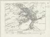
Kent LXVIII.SW - OS Six-Inch Map
1 : 10560 Topographic maps Ordnance Survey Ordnance Survey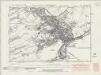
Kent LXVIII.SW - OS Six-Inch Map
1 : 10560 Topographic maps Ordnance Survey Ordnance Survey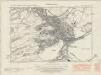
Kent LXVIII.SW - OS Six-Inch Map
1 : 10560 Topographic maps Ordnance Survey Ordnance Survey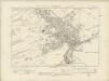
Kent LXVIII.SW - OS Six-Inch Map
1 : 10560 Topographic maps Ordnance Survey Ordnance Survey
Kent LXVIII.SW - OS Six-Inch Map
1 : 10560 Topographic maps Ordnance Survey Ordnance Survey
Kent LXVII.SE - OS Six-Inch Map
1 : 10560 Topographic maps Ordnance Survey Ordnance Survey
Kent LXVII.SE - OS Six-Inch Map
1 : 10560 Topographic maps Ordnance Survey Ordnance Survey
Kent LXVII.SE - OS Six-Inch Map
1 : 10560 Topographic maps Ordnance Survey Ordnance Survey
Kent LXVII.SE - OS Six-Inch Map
1 : 10560 Topographic maps Ordnance Survey Ordnance Survey
Kent LXXV.NW - OS Six-Inch Map
1 : 10560 Topographic maps Ordnance Survey Ordnance Survey
Kent LXXV.NW - OS Six-Inch Map
1 : 10560 Topographic maps Ordnance Survey Ordnance Survey
Kent LXXV.NW - OS Six-Inch Map
1 : 10560 Topographic maps Ordnance Survey Ordnance Survey
Kent LXXV.NW - OS Six-Inch Map
1 : 10560 Topographic maps Ordnance Survey Ordnance Survey
Kent LXXV.NW - OS Six-Inch Map
1 : 10560 Topographic maps Ordnance Survey Ordnance Survey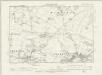
Kent LXXV.NW - OS Six-Inch Map
1 : 10560 Topographic maps Ordnance Survey Ordnance Survey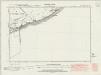
Kent LXVIII.SE - OS Six-Inch Map
1 : 10560 Topographic maps Ordnance Survey Ordnance Survey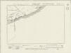
Kent LXVIII.SE - OS Six-Inch Map
1 : 10560 Topographic maps Ordnance Survey Ordnance Survey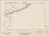
Kent LXVIII.SE - OS Six-Inch Map
1 : 10560 Topographic maps Ordnance Survey Ordnance Survey
Kent LXVIII.SE - OS Six-Inch Map
1 : 10560 Topographic maps Ordnance Survey Ordnance Survey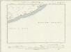
Kent LXVIII.SE - OS Six-Inch Map
1 : 10560 Topographic maps Ordnance Survey Ordnance Survey
Dover, Kent [fire insurance plan] :Key Plan
1 : 3600 This "key plan" indicates coverage of the Goad 1905 series of fire insurance maps of Dover that were originally produced to aid insurance companies in assessing fire risks. The building footprints, their use (commercial, residential, educational, etc.), the number of floors and the height of the building, as well as construction materials (and thus risk of burning) and special fire hazards (chemicals, kilns, ovens) were documented in order to estimate premiums. Names of individual businesses, property lines, and addresses were also often recorded. Together these maps provide a rich historical shapshot of the commercial activity and urban landscape of towns and cities at the time. The British Library holds a comprehensive collection of fire insurance plans produced by the London-based firm Charles E. Goad Ltd. dating back to 1885. These plans were made for most important towns and cities of the British Isles at the scales of 1:480 (1 inch to 40 feet), as well as many foreign towns at 1:600 (1 inch to 50 feet). Chas E Goad Limited Chas E Goad Limited
Kent LXVIII.15 - 25 Inch Map
1 : 2500 Topographic maps Ordnance Survey Ordnance Survey
Kent LXVIII.15 - 25 Inch Map
1 : 2500 Topographic maps Ordnance Survey Ordnance Survey