Maps of Central Lowland

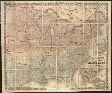
Colton's new railroad & county map of the United States, the Canadas &c.

G. Woolworth Colton's new guide map of the United States & Canada : with railroads, counties etc.
1 : 3168000
United States of America.
1 : 1960000 Tanner, Henry S.
Lay's map of the United States / compiled from the latest and best authorities and actual surveys by Amos Lay, geographer and map publisher ; engraved by O.H. & D.S. Throop & Wm. Chapin.
from Whole
Union Military Chart.
Magnus, Charles
A Connected View of The Whole Internal Navigation of the United States.
1 : 6082560 Tanner, Henry S.
Colton's New Railroad & County Map Of The United States.
1 : 3041280 Colton, J. H.
Composite: Colton's New Railroad & County Map Of The United States.
1 : 3041280 Colton, J. H.
United States of America.
1 : 11960000 Tanner, Henry S.
Map of the United States.
1 : 2407680 Robinson, Lewis
United States of America.
1 : 1960000 Tanner, Henry S.
United States of America.
1 : 1960000 Tanner, Henry S.
United States.
1 : 8363520 Burr, David H., 1803-1875
United States / by David H. Burr, New-York.
from Whole David H. Burr,
United States of America
1 : 2025000
Übersichtskarte über die Endmoräne der zweiten Glacialepoche Nord Amerikas nach T. C. Chamberlin 1882
1 : 15000000 gez. v. E. Geinitz aut. v. C. Schmidt Gotha : Perthes
United States.
1 : 1900800 Lay, Amos
Railroad Map Of The United States And Of The Dominion Of Canada.
1 : 2280960 Watson, Gaylord
United States.
1 : 5400000 W. & A.K. Johnston Limited
Amplissimae regionis Mississipi seu provinciae Ludovicianae â R.P. Ludovico Hennepin Francisc. Miss. in America septentrionali anno 1687
1 : 6500000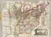
Watson's new rail-road and distance map of the United States and Canada.
1 : 2344320 Watson, Gaylord
United States.
1 : 8000000 Teesdale, Henry
Watson's New County and Railroad Map of the United States.
1 : 2154240 Watson, Gaylord
Map of the United States of America.
1 : 4942080 Maclure, William
United States.
1 : 5400000 W. & A.K. Johnston Limited
United States.
1 : 5400000 W. & A.K. Johnston Limited
Amplissimae regionis Mississipi seu Provinciae Ludovicianae â R.P. Ludovico Hennepin Francisc Miss in America Septentrionali anno 1687
1 : 1
Map of the United States / Euphemia Fenno.
from Whole Euphemia Fenno,
A map of the United States, from the latest surveys.
1 : 4822000 Tuttle, Joseph Willard, 1813-1888