Maps of Coastal Plain
Frank Leslie's war maps
Leslie, Frank
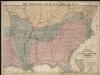
Colton's U.S. section.
1 : 3168000 United States. War Department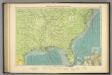
American Atlantic ports S.
1 : 5000000 Philip, George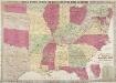
Phelps & Watson's Historical and Military Map of the Border and Southern States.
Phelps & Watson's Historical and Military Map of the Border and Southern States. This map, produced in New York in 1863 shows all the Confederate states, including a sizable amount of Texas, as well as the Border States of the Union. It is noteworthy that by this point in the war, Virginia has split into to, with the western half seceding from the rest of the state. West Virginia was admitted to the Union in 1863 and the map clearly shows the separation. The map also contains a list of the major battles from 1861 and 1862 in the bottom right hand corner.
Johnson's new rail road & county copper plate map of the Southern States from the latest and best information
1 : 3150000 Johnson, A. J. Johnson & Browning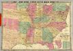
Historical And Military Map Of The Border & Southern States.
1 : 2534400 Phelps & Watson
Map, showing the Distribution of Slaves in the Southern States. Projected and compiled by A. von Steinwehr.
Map, showing the Distribution of Slaves in the Southern States. Projected and compiled by A. von Steinwehr. This map shows the breakdown of slave-ownership by each county with the darker colour indicating a higher percentage of slaves. The map includes a smaller depiction of where the majority of cotton and sugar production occurred. The map thus shows the extent of the slave system before the war. Von Steinwehr was German-born general in the Union Army who fought at many of the war’s prominent battles, including the First Battle of Bull Run and the Battle of Gettysburg. Alongside fighting, he was a keen cartographer, as this map demonstrates.
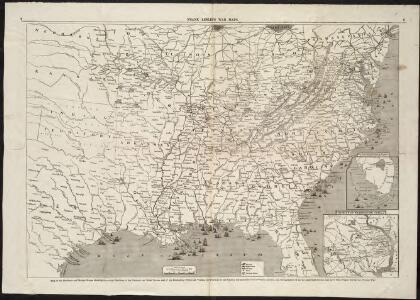
War Maps And Diagrams. Our Naval And Military Operations At A Glance.
1 : 6336000 New York Herald
US, Canada.
1 : 11500000 Peterson, Augusts
Hanmer's Map of the American Cotton States
Hanmer's Map of the American Cotton States. Produced in 1902 for the Liverpool cotton brokers, Hanmer & Co., this map shows the extent of cotton production in America. The map covers virtually all of the Southern states as well as several of the Border State regions. The map is a good example of how prolific cotton production was in America, though it is worth noting that cotton harvesting was undertaken by slaves, thus the map highlights the areas where slavery was most prevalent. All eleven seceded states appear on this map, demonstrating just why the Confederates believed cotton and slavery to be the cornerstones of their independence and prowess.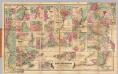
Colton's Plans Of U.S. Harbors.
Colton, J. H.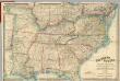
Map Of The Southern States of North America
1 : 2025000 Wyld, James, 1812-1887
Carte de la Louisiane et du cours du Mississipi dressée sur un grand nombre de memoires entr'autres sur ceux de Mr. le Maire, / par Guillme. de L'Isle de l'Academie Rle. des Sciences.
from Charts and maps Guillaume de l'Isle; Mr. le Maire,
Carte de la Louisiane et du cours du Mississipi dressée sur un grand nombre de memoires entr'autres sur ceux de Mr. le Maire, / par Guillme. de L'Isle de l'Academie Rle. des Sciences.
from Charts and maps Guillaume de l'Isle; Mr. le Maire,
Carte de la Louisiane et du cours du Mississipi: dressée sur un grande nombre de memoires entrautres sur ceux de Mr. le Maire / par Guillaume Delisle de lAcademie rle. des sciences.
from Whole Guillaume de l'Isle; Mr. le Maire,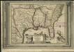
La Floride, suivant les nouvelles observations de Messrs. de l'Academie des Sciences, etc.
1 : 9000000 Aa, Pieter van der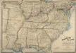
Map of the Southern States of North America, with the Forts, Harbours, and Military Positions
Map of the Southern States of North America, with the Forts, Harbours, and Military Positions. This map, published by Wyld in 1865, shows much of the Confederacy and the Border States as they were at the end of the Civil War. The divide between Virginia and West Virginia is marked, along with ‘forts, harbours & military positions’. The dark black lines indicated railway routes and it is notable how many more there are in the small segment of the Northern states displayed at the top of the map in comparison to the Confederate states. J. Wyld
The historical war map
Map of the Southern States of North America, with the Forts, Harbours and Military Positions.
Map of the Southern States of North America, with the Forts, Harbours and Military Positions. Published by Wyld in 1862, Map of the Southern States of North America shows all the Confederate states, including the edge of Texas, and several of the Northern Border States too. Each state border is clearly defined. The map also labels ‘forts, harbours & military positions’, as well as marking the line between slave and free states, railways and canals. J. Wyld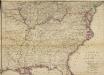
Woolley's new Map of the Seat of War in the Confederate States of America.
Woolley's new Map of the Seat of War in the Confederate States of America. Published in London, probably in 1861, Woolley’s New Map of the Seat of War in the Confederate States of America details the whole eastern half of the country. The red and green lines indicated which states held slaves and which states did not. The map shows all the Confederate states, excluding Texas, and shows how the Border States of Missouri and Kentucky were also slave-holding despite remaining part of the Union. H.G. Clarke & Co.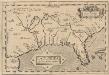
La Florida. [Karte], in: Theatrum orbis terrarum, S. 74.
1 Karte aus Atlas Ortelius, Abraham Vrients, Jan Baptista
Perrine's New Topographical War Map Of The Southern States.
1 : 2000000 Perrine, Charles O.
The Historical War Map.
1 : 3294720 Russell, Benjamin B.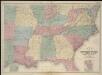
Map of the seat of war
Lloyd's Map Of The Southern States.
1 : 2027520 Lloyd, J. T.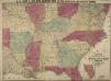
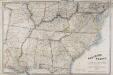
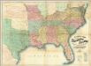
Lloyd's New Military Map of the Border and Southern States
Lloyd's New Military Map of the Border and Southern States. This map was published by H.H. Lloyd & Co. in 1862. The map shows mid America from the lower border of the Union to the eastern edge of Texas, thus showing all eleven Confederate states. Railway lines and fortifications are also labelled on the map.
Southern section of the United States, including Florida &c. / by John Melish, 1816.
from Parts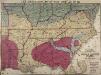
Lloyd's New Military Map of the Border and Southern States
Lloyd's New Military Map of the Border and Southern States. Lloyd’s New Military Map of the Border and Southern States from 1865 provides a clear example of the territory held by the Confederate and Union Armies at the end of the Civil War. The red parts indicated Confederate territory, now very much reduced compared to the other maps, the yellow parts show areas gained by the Union Army since early January 1862 and the blue part shows the route taken by General Sherman’s troops during their march through the South. The green indicates the Union. This map highlights how divided the Border States were with portions of Missouri and Kentucky coloured to indicate Union occupation. Although these both remained in the Union, internal civil struggles threatened to divide the states and Lincoln campaigned hard to ensure these states remained together. By comparison, Virginia witnesses an internal secession in 1863 and West Virginia can clearly be seen here on this map as part of the Union. This map is one of the best maps in the collection that detail how far the Union Army went into occupying the Confederate states and reuniting the country.
Perrine's New Military Map Illustrating The Seat of War.
1 : 2724480 Perrine, Charles O.