Maps of Japan

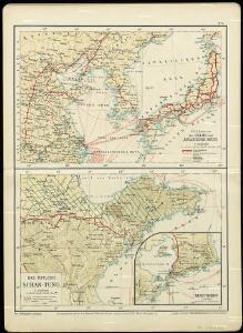
Die Länder im das Gelbe und Japanische MeerDas östliche Schan-Tung

Imperii Sinarum Nova Descriptio [Karte], in: Novus atlas absolutissimus, Bd. 11, S. 14.
1 Karte aus Atlas Janssonius Offizin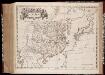
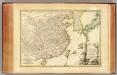
Imperii Sinarvm nova descriptio
1 : 8000000 Annotatie: Cum privilegio Sacrae Caesareae Majestatis & Ordinum Belgicae Foederatae; Origineel is Blad 196 in atlas factice [Amsterdam : J. Blaeu]
Imperii Sinarum nova descriptio
1 : 8000000 Amstelodami : ex officina J. Cóvens et C. Mortier
Imperii Sinarum Nova Descriptio. [Karte], in: Novus atlas Sinensis, S. 16.
1 Karte aus Atlas Martini, Martino Blaeu, Joan
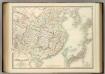
IMPERII | SINARVM | NOVA DESCRIPTIO
[Amsterdam : Joan Blaeu]

The empire of China and island of Iapan
1 : 18600000 Japonsko Moll, Herman
Karten - Skizzen für die Schul - Praxis
China and Japan.
1 : 6198300 Johnston, Alexander Keith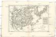
Empire de la Chine, r. de Corée et isles du Japon
1 : 12640000 Japonsko Bonne, Rigobert André
Ostasien
1 : 4500000 Asie východní Herrich, Alwin Carl Flemming
Ostasien
1 : 4500000 Asie východní Herrich, Alwin Carl Flemming
Ostasien
1 : 4500000 Asie východní Herrich, Alwin Carl Flemming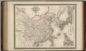
China and Japan.
1 : 9000000 Johnson, A.J.
China (Östl. Theil), Korea und Japan
Hand-Atlas über alle Theile der Erde und über das Weltgebäude Stieler, Adolf Justus Perthes
China (Ostl. Theil), Korea Und Japan.
1 : 7500000 Petermann, A.
Asia (Eastern Sheet).
1 : 14606000 Fisher, Richard Swainson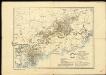
General overview of the area worked by the Basel Mission in Canton province, China
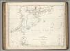
Chart of Discoveries, Made in 1787, in the Seas of China and Tartary, Sheet I.
1 : 7500000 La Perouse, Jean-Francois de Galaup, comte de, 1741-1788
[Ost-China, Korea und Japan]
Adolf Stieler's Handatlas über alle Theile der Erde und über das Weltgebäude Stieler, Adolf Justus Perthes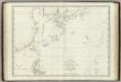
Mers, Chine, Tartarie. 1.
1 : 6250000 La Perouse, Jean-Francois de Galaup, comte de, 1741-1788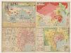
廣東香港明細地圖. 漢口南昌明細地圖
1 : 820000 廣東香港明細地圖•漢口南昌明細地圖 昭和十三年[1938]3月1日,淵田忠良 编辑,东京:大日本雄辯會講談社 正面为《廣東香港明細地圖》,以珠三角为中心的行政图,包括香港,绘制了铁路、公路、河网和航空线,标注了县治及部分乡镇地名。附插图3幅:《汕頭附近》,为粤东地区行政区划图;《廣東》,为广州城地形简图;《香港》为维多利亚海湾两岸等高线地形图。 背面为《漢口南昌明細地圖》,西起洞庭湖,东至太湖西侧,南抵湖南、江西中部的湘潭-抚州一线,北达南京、信阳一带,以长江中游汉口-南昌-南京为中心,包括洞庭湖、鄱阳湖、巢湖等。绘制了该区域较为详细的村镇地名和交通线。 背面的汉口图较广东图详细,应与此时日军正大举进攻长江中游,并即将发动武汉会战的战争局势密切相关。 2图,黑蓝双色,日文,图幅39.5 x 54.5 cm,比例尺分别为1:820,000和1:1,500,000,无经纬线。 Harvard-YenchingManchuguo J-0886;Hollis Number:014636952 淵田忠良 大日本雄辯會講談社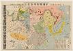
北支事變明細圖解 : 日·満·露·支·蒙·関係一覽.
北支事變明細圖解 昭和十二年[1937]8月22日 东京:東京日日新聞社 此图是在《東亜危機明細図解》(014623780)上修改而成,主图内容是1937年中国的军事形势,东北地区中苏边界上,苏联部署重兵包围了伪满洲国。华北地区沦陷并成立了冀东傀儡政权。国民党主要控制淮河以南地区。 插图1幅《北支事變要圖》。 1图,彩色,日文,图幅53.6 x 77.2 cm,无比例尺和经纬线。 Harvard-YenchingManchuguo J-0828;Hollis Number:014623845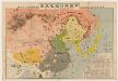
東亜危機明細図解 : 恐るべし日満包囲馬蹄陣形 : 日満露支蒙関係一覧.
東亜危機明細図解:恐るべし日満包囲馬蹄陣形 昭和十一年[1936]10月10日,东京:东京日日新聞社 该图标示出苏联红军重兵包围东北,沿着东北中苏边界修筑防线,进而形成对东北和华北地区的马蹄形包围。同时,苏联从西北方向中国输送物质弹药,西北地区已赤化,并不断向东推进。华北地区则有多个国民党军头控制,淮河以南地区除了广西外,主要由蒋介石中央政府控制,并向北推进。该图用图画标注各地主要物产,并用贴了各地军政首脑头像。 1图,彩色,日文,图幅53.5 x 77.6 cm,无比例尺和经纬度线。 Harvard-YenchingManchuguo J-0822;Hollis Number:014623780 东京日日新聞社
萬國通鑑:中國地圖
美国传教士撰的向中国人介绍世界地理概况的著作,后有世界地图册1份,共13幅世界、大洲和区域地图,其中一幅题为《中國地圖》的清朝内地地图。 Sheffield, Devello Zelotos 謝衛樓 福州 : 美華書局
China and Japan
1 : 8820000 Annotatie: Blad 41 uit: Edinburgh imperial atlas. - Edinburgh : Gall & Inglis, 1850 Edinburgh : Lloyd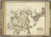
China, Japan.
1 : 7500000 Playfair, Principal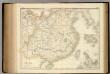
China.
1 : 6019200 Fullarton, A. & Co.