Old maps of Naumburg (Saale)

Discover the past of Naumburg (Saale) on historical maps

Browse the old maps

Discovering the Cartography of the Past

Naumburg (Saale)


Parent places:

Related places:

City

Maps of Naumburg (Saale)

Maps of Naumburg (Saale)

$title$

Meßtischblatt 4836 : Naumburg, 1937

1 : 250000 Naumburg. - Hrsg. 1905, einz. Nachtr. 1931, gedr. [19]37. - 1:25000. - [Berlin]: Reichsamt für Landesaufnahme, 1937. - 1 Kt.
$title$

Meßtischblatt 2809 : Naumburg an der Saale, 1918

1 : 250000 Naumburg an der Saale. - Aufn. 1903, hrsg. 1905, Aufldr. 1918. - 1:25000. - [Berlin]: Reichsamt für Landesaufnahme, 1918. - 1 Kt.
$title$

Meßtischblatt 2809 : Naumburg, 1916

1 : 250000 Naumburg. - Aufn. 1903, hrsg. 1905, Aufl.-dr. 1916. - 1:25000. - [Berlin]: Reichsamt für Landesaufnahme, 1916. - 1 Kt.
$title$

Meßtischblatt 2809 : Naumburg, 1906

1 : 250000 Naumburg. -[Aufn. 1903, hrsg. 1905], gedr. [19]06. - 1:25000. - [Berlin]: Reichsamt für Landesaufnahme, 1906. - 1 Kt.
$title$

Meßtischblatt 2809 : Naumburg, 1905

1 : 250000 Naumburg. - Aufn. 1903, hrsg. 1905. - 1:25000. - [Berlin]: Reichsamt für Landesaufnahme, 1905. - 1 Kt.
$title$

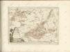
Treffen bey Rossbach, in Sachsen, welches den 5.ten Novembr. 1757. von dem Koenig von Preussen, über die franzoesische und Reichsarmée, unter Commando des Prinzen von Soubise und Prinzen von Sachsen Hildburgshausen, gewonnen worden.

1 : 62000 Rossbach (Německo) Brequin Birckhart, C.
$title$

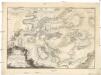
Combat de Rossbach, en Saxe, gagné par le roi de Prusse sur l'armée françoise, aux ordres du prince de Soubise, et sur celle de l'Empire, commandée par le prince de Saxe-Hildburghausen, le 5. novembre, 1757

1 : 62000 Rossbach (Německo)
$title$

Meßtischblatt 4936 : Camburg, 1938

1 : 250000 Camburg. - Hrsg. 1905, einz. Nachtr. 1928, redakt. Änd. [19]38. - 1:25000. - [Berlin]: Reichsamt für Landesaufnahme, 1938. - 1 Kt.
$title$

Meßtischblatt 2872 : Camburg, 1913

1 : 250000 Camburg. - Aufn. 1903, hrsg. 1905, Aufl.-dr. 1913. - 1:25000. - [Berlin]: Reichsamt für Landesaufnahme, 1913. - 1 Kt.
$title$

Meßtischblatt 2872 : Camburg, 1913

1 : 250000 Camburg. - Aufn. 1903, hrsg. 1905, Aufl.-dr. 1913. - 1:25000. - [Berlin]: Reichsamt für Landesaufnahme, 1913. - 1 Kt.
$title$

Meßtischblatt 2872 : Camburg, 1905

1 : 250000 Camburg. - Aufn. 1903. - 1:25000. - [Berlin]: Reichsamt für Landesaufnahme, 1905. - 1 Kt.
$title$

$title$

Episcopatus Numburgensis...

$title$

Accurate Geographische Delineation Des Stiffts Naumburg und Zeitz

1 : 120000 Mollova mapová sbírka Frankendaal, Nicolaas van Schenk, Peter II
$title$

Episcopatus Numburgensis Et Cizensis Delineatio geographica

1 : 120000 Mollova mapová sbírka Lotter, Tobias Conrad Seutter, Matthäus
$title$

Das Stifft Naumburg und Zeitz nebst einen grossen Theil derer angraentzenden Laender

1 : 130000 Mollova mapová sbírka Schreiber, Johann Georg Schreiber, Johann Georg
$title$

Chorographia Territorii Naumburgo-Citiensis

1 : 90000 Mollova mapová sbírka Schreiber, Johann Georg Homann, Johann Baptista - dědici
$title$

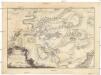
Plan de la Bataille, Gagnée par Sa Majesté le Roi de Prusse, contre les Armées combinées de l'Empire & de France, près de Rosbach, le 5. Novembre, 1757

1 : 95000 Mollova mapová sbírka Schley, Jacobus van der Hondt, Pierre de
$title$

Jena und Auerstedt 14. Oktober 1806

1 : 300000 Jena Doppelschlacht von Jena und Auerstedt
$title$

Plan de la bataille, gagnée par Sa Majesté le roi de Prusse, contre les armées combinées de l'empire & de France, prés de Rosbach, le 5. novembre 1757

Rossbach (Německo) Schley, Jacobus van der Hondt, Pierre de Pierre de Hondt
$title$

Meßtischblatt 2810, neue Nr. 4837 : Stößen, 1937

1 : 250000 Stößen. - Hrsg. 1908, bericht. 1924, einz. Nachtr. 1937. - 1:25000. - [Berlin]: Reichsamt für Landesaufnahme, 1937. - 1 Kt.
$title$

Meßtischblatt 2810 : Stößen, 1935

1 : 250000 Stößen. - Hrsg. 1908, bericht. 1924, einz. Nachtr. 1931. - 1:25000. - [Berlin]: Reichsamt für Landesaufnahme, [19]35. - 1 Kt.
$title$

Meßtischblatt 2810 : Stössen, 1912

1 : 250000 Stössen. - Aufn. 1906, hrsg. 1908, Nachtr. 1912. - 1:25000. - [Berlin]: Reichsamt für Landesaufnahme, 1912. - 1 Kt.
$title$

Meßtischblatt 2810 : Stössen, 1878

1 : 250000 Stössen. - Aufn. 1868, hrsg. 1872, bericht. 1878. - 1:25000. - [Berlin]: Reichsamt für Landesaufnahme, 1878. - 1 Kt.
$title$

Meßtischblatt 4835 : Eckartsberga, 1938

1 : 250000 Eckartsberga. - Hrsg. 1906, einz. Nachtr. 1931, redakt. Änd. [19. - 1:25000. - [Berlin]: Reichsamt für Landesaufnahme, 1938. - 1 Kt.
$title$

Meßtischblatt 2808 : Eckartsberga, 1906

1 : 250000 Eckartsberga. - Aufn. 1903. - 1:25000. - [Berlin]: Reichsamt für Landesaufnahme, 1906. - 1 Kt.
$title$

Meßtischblatt 4937 : Osterfeld, 1937

1 : 250000 Osterfeld. - Hrsg. 1908, bericht. 1924, einz. Nachtr. 1937. - 1:25000. - [Berlin]: Reichsamt für Landesaufnahme, 1937. - 1 Kt.
$title$

Meßtischblatt 2873 : Osterfeld, 1935

1 : 250000 Osterfeld. - Hrsg. 1908, bericht. 1924, einz. Nachtr. 1931. - 1:25000. - [Berlin]: Reichsamt für Landesaufnahme, [19]35. - 1 Kt.
$title$

Meßtischblatt 2873 : Osterfeld, 1924

1 : 250000 Osterfeld. - Aufn. 1906, bericht. 1924. - 1:25000. - [Berlin]: Reichsamt für Landesaufnahme, 1924. - 1 Kt.
$title$

146 Jena, uit: Topographische Special-Karte von Deutschland (von Central-Europa) / begründet von D.G. Reymann ; [entworfen und gezeichn. von Heinrich Berghaus... [et al.]]

1 : 200000 Annotatie: Lit.: Daniel Gottlob Reymann und die "Topographische Special-Karte von Deutschland" / von Wolfgang Scharfe, in: Kartographische Nachrichten, 39 (1989), Heft I, p. 1-10; Handgeschreven titel: Reymann's Deutschland : 24 Sectionen: Jena, Penig, Dresden, Zittau, Hirschberg, Breslau, Brieg, Andernach, Coblenz, Giessen, Fulda, Schleusingen, Plauen, Zwickau, Teplitz, Jung Bunzlau, Hohenelbe, Glatz, Neisse, Simmern, Prag, Luxemburg, Birkenfeld; Aanwezig: 23 bladen Reymann, Daniel Gottlob; Berghaus, Heinrich [Berlin : 2. Departement des Kriegsministeriums, Bureau für Plan- und Kartenzeichnung]
© MapTiler © OpenStreetMap contributors
How does it work?
These instructions will show you how to find historical maps online.
Getting started
Type the place name in the search box to find the exact location. You can further adjust the search by zooming in and out.
Zoom
Zoom in and out with the buttons or use your mouse or touchpad natively.
Exact Area tool
Click here and draw a rectangle over the map to precisely define the search area.
Set filters
Narrow your search with advanced settings, such as Years (from/to), Fulltext, Publisher, etc.
Results
See the results of your search on the right side. You can scroll down to find more maps of this location.
?

Download OldMapsOnline Mobile