Old maps of Piszkawa

Discover the past of Piszkawa on historical maps

Browse the old maps

Discovering the Cartography of the Past

Piszkawa


Parent places:

Maps of Piszkawa

Maps of Piszkawa

$title$

Meßtischblatt 2829 : Sibyllenort, 1932

1 : 250000 Sibyllenort. - Hrsg. 1887, bericht. 1926, einz. Nachtr. 1932. - 1:25000. - [Berlin]: Reichsamt für Landesaufnahme, 1932. - 1 Kt.
$title$

152 Brieg, uit: Topographische Special-Karte von Deutschland (von Central-Europa) / begründet von D.G. Reymann ; [entworfen und gezeichn. von Heinrich Berghaus... [et al.]]

1 : 200000 Annotatie: Lit.: Daniel Gottlob Reymann und die "Topographische Special-Karte von Deutschland" / von Wolfgang Scharfe, in: Kartographische Nachrichten, 39 (1989), Heft I, p. 1-10; Handgeschreven titel: Reymann's Deutschland : 24 Sectionen: Jena, Penig, Dresden, Zittau, Hirschberg, Breslau, Brieg, Andernach, Coblenz, Giessen, Fulda, Schleusingen, Plauen, Zwickau, Teplitz, Jung Bunzlau, Hohenelbe, Glatz, Neisse, Simmern, Prag, Luxemburg, Birkenfeld; Aanwezig: 23 bladen Reymann, Daniel Gottlob; Berghaus, Heinrich [Berlin : 2. Departement des Kriegsministeriums, Bureau für Plan- und Kartenzeichnung]
$title$

Wege - Karte der Gegend um Breslau

$title$

119. Breslau, uit: Topographische Uebersichtskarte des Deutschen Reiches / herausgegeben v. d. Kartogr. Abt. d. Königl. Preuß. Landesaufnahme

1 : 200000 titelvariant: Topogr. Übersichtskarte des Deutschen Reiches; Annotatie: Titel boven bladen ook: Topogr. Übersichtskarte des Deutschen Reiches; Annotatie geografische gegevens: Op elk blad twee maatstokken: 10 Kilometer = 5,5 cm; 1 geogr. Meile = 3,6 cm; Legenda onder op elk blad Königlich Preußische Landesaufnahme. Kartographische Abtheilung [S.l : Königlich Preußische Landesaufnahme, Kartographische Abtheilung]
$title$

Das Fürstenthum Bresslau in Nieder-Schlesien

1 : 720000 Vratislav-oblast (Polsko) Schleuen, Johann David Schleuen
$title$

Das Fürstenthum Bresslau in Nieder-Schlesien

1 : 458300 Mollova mapová sbírka Schleuen, Johann David
$title$

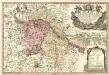
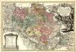
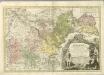
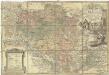
Principtus Silesiae Wratislaviensis exactissima Tabula Geographica sistens simul Circulum Neoforensem et Districtum Cantiensem, ac status minores vulgo Burglehn dictos Lissa, Kraicka, Weigwitz, Rommenau, Krolkwitz, Bogenau, Malckwitz, Auras, Gr. Peterwitz et Halt Grosburg

1 : 120000 Mollova mapová sbírka Wieland, Johann Wolfgang Homann, Johann Christoph
$title$

Principatus Silesiae Wratislaviensis :

1 : 120000 Mollova mapová sbírka Wieland, Johann Wolfgang Homann, Johann Baptista - dědici
$title$

Ducatus Breslanus sive Wratislaviensis

1 : 240000 Mollova mapová sbírka Aveele, Johannes van den Schenk, Peter I
$title$

Dvcatvs Breslanvs sive Wratislaviensis

1 : 220000 Mollova mapová sbírka Vechner, Georg Blaeu, Joan I.
$title$

La Haute et la Basse Silesie

1 : 3330000 Slezsko Lotter, Tobias Conrad Tobie Conrad Lotter
$title$

Das Fürstenthum Oels in Nieder-Schlesien nebst denen freyen Standes-Herrschaften Trachenberg, Militsch und Wartenberg

1 : 417770 Mollova mapová sbírka Schleuen, Johann David Schleuen, Johann David
$title$

Ducatus in Silesia Inferiore Olsnensis Novissima Delineatio

1 : 208000 Mollova mapová sbírka Schenk, Pieter Schenk, Peter II
$title$

Dvcatvs in Silesia Inferiore Olsnensis Novißima Delineato

1 : 216000 Mollova mapová sbírka Sinapius, Daniel Winckler, Christian
$title$

Das Fürstenthum Oels in Nieder-Schlesien nebst denen freyen Standes-Herrschafften Trachenberg, Militsch und Wartenberg

Oleśnica (Vratislav, Polsko) Wieland, Johann Wolfgang Schleuen, Johann David I.D. Schleuen
$title$

$title$

Das Fürstenthum Brieg in Nieder-Schlesien

1 : 460000 Dolní Slezsko Schleuen, Johann David I.D. Schleuen
$title$

Principatvs Silesiae Bregensis

1 : 145000 Mollova mapová sbírka Wieland, Johann Wolfgang Homann, Johann Baptista - dědici
$title$

$title$

Principatvs Silesiae Oelsnensis :

1 : 154000 Mollova mapová sbírka Wieland, Johann Wolfgang Homann, Johann Baptista - dědici
$title$

Principatus Silesiae Wratislaviensis

1 : 129000 Vratislav-oblast (Polsko) Wieland, Johann Wolfgang Schubarth, Matthäus Haeredibus Homannianis
$title$

Principatus Silesiae Wratislaviensis

1 : 130000 Vratislav-oblast (Polsko) Wieland, Johann Wolfgang Schubarth, Matthäus ab Haeredibus Homannianis
$title$

$title$

DVCATVS | BRESLANVS | sive | WRATISLAVIENSIS

Amstelædami, Apud Joan. Blaeu
$title$

$title$

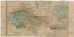
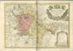
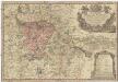
Principatvs Silesiae Oelsnensis in suos districtus Oels Bernstadt et Trebnitz divisi exactissima tabula geographica, exhibens insimul circumjacentes dynastias liberas Trachenberg et Militsch, cum statibus minoribus Freyhain Nevschlos, Goschvtz et Zvlavf

1 : 154000 Oleśnica (Vratislav, Polsko) Wieland, Johann Wolfgang Schubarth, Matthäus Haeretibus Homannianis
$title$

$title$

Breslau 77, uit: Special-Karte von Mittel-Europa / nach amtlichen Quellen bearbeitet von W. Liebenow

1 : 300000 titelvariant: W. Liebenow's Mittel-Europa; Annotatie: Titel boven de bladen: W. Liebenow's Mittel-Europa Johannes Wilhelm Liebenow 1822-1897 Frankfurt a. M. : Ludwig Ravenstein
$title$

Ducatus Breslanus sive Wratislaviensis. [Karte] Breslaw totius Silesiae Metropolis. [Nebenkarte], in: Novus atlas absolutissimus, Bd. 2, S. 264.

1 Karte aus Atlas Janssonius Offizin
$title$

© MapTiler © OpenStreetMap contributors
How does it work?
These instructions will show you how to find historical maps online.
Getting started
Type the place name in the search box to find the exact location. You can further adjust the search by zooming in and out.
Zoom
Zoom in and out with the buttons or use your mouse or touchpad natively.
Exact Area tool
Click here and draw a rectangle over the map to precisely define the search area.
Set filters
Narrow your search with advanced settings, such as Years (from/to), Fulltext, Publisher, etc.
Results
See the results of your search on the right side. You can scroll down to find more maps of this location.
?

Download OldMapsOnline Mobile