Old maps of Alsfeld

Discover the past of Alsfeld on historical maps

Browse the old maps

Discovering the Cartography of the Past

Alsfeld


Parent places:

Maps of Alsfeld

Maps of Alsfeld

$title$

Meßtischblatt 3049 : Lingelbach, 1908

1 : 250000 Lingelbach. - Aufn. 1906. - 1:25000. - [Berlin]: Kgl. Preuss. Landesaufnahme, 1908. - 1 Kt.
$title$

Section Alsfeld

Eckhardt, Christian Leonhard Philipp; Haas, Johann Heinrich; Meister, G.; Klos
$title$

Ungefährlicher Entwurf den Ämbter Alssfeldt, Rümrodt, Grebenau, der Gerichte Schwarz und von Süsser Gerichte

1 : 35000 [S.l. : s.n.]
$title$

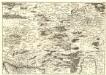
162 Giessen, uit: Topographische Special-Karte von Deutschland (von Central-Europa) / begründet von D.G. Reymann ; [entworfen und gezeichn. von Heinrich Berghaus... [et al.]]

1 : 200000 Annotatie: Lit.: Daniel Gottlob Reymann und die "Topographische Special-Karte von Deutschland" / von Wolfgang Scharfe, in: Kartographische Nachrichten, 39 (1989), Heft I, p. 1-10; Handgeschreven titel: Reymann's Deutschland : 24 Sectionen: Jena, Penig, Dresden, Zittau, Hirschberg, Breslau, Brieg, Andernach, Coblenz, Giessen, Fulda, Schleusingen, Plauen, Zwickau, Teplitz, Jung Bunzlau, Hohenelbe, Glatz, Neisse, Simmern, Prag, Luxemburg, Birkenfeld; Aanwezig: 23 bladen Reymann, Daniel Gottlob; Berghaus, Heinrich [Berlin : 2. Departement des Kriegsministeriums, Bureau für Plan- und Kartenzeichnung]
$title$

Bewegungen der Alliirten, und Französischen Armee zwischen dem 19ten und 21ten März 1761, nebst Aufstellung und Rückzug der Alliirten am 23ten und 24ten

$title$

$title$

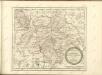
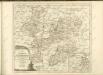
Territorium Abbatiae Heresfeldensis. 't Stift Hirßfeldt. [Karte], in: Le théâtre du monde, ou, Nouvel atlas contenant les chartes et descriptions de tous les païs de la terre, Bd. 1, S. 184.

1 Karte aus Atlas Blaeu, Willem Janszoon und Blaeu, Joan Blaeu, Willem Janszoon
$title$

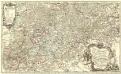
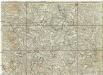
Territorium Abbatiae Heresfeldensis. 't Stift Hirszfeldt. [Karte], in: Novus Atlas, das ist, Weltbeschreibung, Bd. 1, S. 153.

1 Karte aus Atlas Blaeu, Joan Blaeu, Willem Janszoon
$title$

Territorivm abbatiae Heresfeldensis = 't Stift Hirszfeldt

1 : 70000 titelvariant: 't Stift Hirszfeldt; Annotatie: Origineel is Blad 103 in atlas factice; Annotatie geografische gegevens: Schaalvermeldingen linksonder: Dimidium milliaris Haßici, en: Dimidium milliaris Germanici Willem Jansz Blaeu 1571-1638 [Amsterdami : apud Guiljelmum Blaeu]
$title$

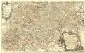
Abbatia Heresfeldensis. vulgo 't Stifftt Hirsfeldt. [Karte], in: Gerardi Mercatoris et I. Hondii Newer Atlas, oder, Grosses Weltbuch, Bd. 1, S. 295.

1 Karte aus Atlas Mercator, Gerhard und Hondius, Jodocus Jansson, Jan
$title$

Territorium Abbatiae Heresfeldensis. 't Stift Hirßfeldt. [Karte], in: Novus atlas absolutissimus, Bd. 2, S. 171.

1 Karte aus Atlas Janssonius Offizin
$title$

Meßtischblatt 5122 : Neukirchen i. Hessen-Nassau,1941

1 : 250000 Neukirchen i. Hessen-Nassau. - Hrsg. 1908, letzte Nachtr. 1939, Ausg. 1941. - 1:25000. - [Berlin]: Reichsamt für Landesaufnahme, 1941. - 1 Kt.
$title$

Landgrafiatvs Hasso-Cassellanvs typo geographico quatuor Foliorum expressus Cura Homannianorum Heredum Norimb: 1761

1 : 160000 Mollova mapová sbírka Homann, Johann Baptist Homann, Johann Baptista - dědici
$title$

Delineatio Geographica generalis comprehendens VI. Foliis Singulos Principatvs Comitatvs Ditiones Dynastias omnes quotquot Imperio Serenissimi Principis Landgrafii Hasso-Darmstadiensis subsunt :

1 : 180000 Mollova mapová sbírka Bronner, Christian Maximilian Homann, Johann Baptista - dědici
$title$

Landgraviatus Hassiae Inferioris Comitatvs Waldeciae Eichsfeldiae Tabvla Geographica

1 : 140000 Mollova mapová sbírka Berger, Daniel
$title$

Hassiae Svperioris et Wetterav. Partis Delineatio

1 : 170000 Mollova mapová sbírka Bronner, Christian Maximilian Homann, Johann Baptista - dědici
$title$

Eisenach 86, uit: [W. Liebenow's Special-Karte von Mittel-Europa]

1 : 300000 titelvariant: W. Liebenow's Mittel-Europa; Annotatie: Titel boven de bladen: W. Liebenow's Mittel-Europa Johannes Wilhelm Liebenow 1822-1897 Hannover : Hermann Oppermann
$title$

Eisenach 86, uit: Special-Karte von Mittel-Europa / nach amtlichen Quellen bearbeitet von W. Liebenow

1 : 300000 titelvariant: W. Liebenow's Mittel-Europa; Annotatie: Titel boven de bladen: W. Liebenow's Mittel-Europa Johannes Wilhelm Liebenow 1822-1897 Frankfurt a. M. : Ludwig Ravenstein
$title$

Partie Méridionale du Langraviat de Hesse-Cassel avec une Partie de la Vetteravie

1 : 200000 Mollova mapová sbírka Carlet, Louis-François Coentgen, Heinrich Hugo Broenner, Heinrich Ludwig
$title$

Cassel

1 : 300000 R. Mittelbach
$title$

Partie Méridionale du Langraviat de Hesse-Cassel avec une Partie de la Vetteravie

1 : 200000 Mollova mapová sbírka Carlet, Louis-François Coentgen, Heinrich Hugo Broenner, Heinrich Ludwig
$title$

S. R. Imp. Circuli Franconici Geographica Delineatio Francken-Land mit Seinen Gräntzen

Mollova mapová sbírka Endter, Wolfgang Moritz Endter, Wolfgang Moritz
$title$

Partie méridionale du langraviat de Hesse-Cassel

Hesensko (Německo) Carlet, Louis-François Broglie, Victor-François de chez Henrii Louis Broenner
$title$

Buchaviae, sive Fuldensis Ditionis Typus. [Karte], in: Theatrum orbis terrarum, S. 236.

1 Karte aus Atlas Ortelius, Abraham Vrients, Jan Baptista
$title$

$title$

$title$

Buchaviae, sive Fuldensis Ditionis Typus. [Karte], in: Theatrum orbis terrarum, S. 144.

1 Karte aus Atlas Ortelius, Abraham
$title$

Vestrovaldia ad septentrionem sita in IV. mappis geogr. proposita cum adiac. regionibus cum plurim. privil

1 : 171000 Fulda (Německo) Buna, Wilhelm C. Reinhardt, Andreas
$title$

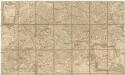
[La baße partie du cercle du Haut-Rhein, divisé en tous ses etats et souverainetes, ou sont le landgraviat de Hesse, les Abbayes de Fulde, et d' Hirschfeld, avec les seigneuries de Wetteravie] et une partie de Westerwald

1 : 171000 Bad Hersfeld (Německo) Buna, Wilhelm C.
$title$

Vestrovaldia ad Septentrionem sita in IV. Mappis Geogr: Proposita cum adiac: Regionibus. cum Plurim: Privil:

1 : 210000 Mollova mapová sbírka Buna, Wilhelm C. Broenner, Heinrich Ludwig
© MapTiler © OpenStreetMap contributors
How does it work?
These instructions will show you how to find historical maps online.
Getting started
Type the place name in the search box to find the exact location. You can further adjust the search by zooming in and out.
Zoom
Zoom in and out with the buttons or use your mouse or touchpad natively.
Exact Area tool
Click here and draw a rectangle over the map to precisely define the search area.
Set filters
Narrow your search with advanced settings, such as Years (from/to), Fulltext, Publisher, etc.
Results
See the results of your search on the right side. You can scroll down to find more maps of this location.
?

Download OldMapsOnline Mobile