Old maps of Vogelsbergkreis

Discover the past of Vogelsbergkreis on historical maps

Browse the old maps

Discovering the Cartography of the Past

Vogelsbergkreis


Parent places:

Related places:

City

Maps of Vogelsbergkreis

Maps of Vogelsbergkreis

$title$

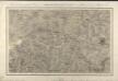
162 Giessen, uit: Topographische Special-Karte von Deutschland (von Central-Europa) / begründet von D.G. Reymann ; [entworfen und gezeichn. von Heinrich Berghaus... [et al.]]

1 : 200000 Annotatie: Lit.: Daniel Gottlob Reymann und die "Topographische Special-Karte von Deutschland" / von Wolfgang Scharfe, in: Kartographische Nachrichten, 39 (1989), Heft I, p. 1-10; Handgeschreven titel: Reymann's Deutschland : 24 Sectionen: Jena, Penig, Dresden, Zittau, Hirschberg, Breslau, Brieg, Andernach, Coblenz, Giessen, Fulda, Schleusingen, Plauen, Zwickau, Teplitz, Jung Bunzlau, Hohenelbe, Glatz, Neisse, Simmern, Prag, Luxemburg, Birkenfeld; Aanwezig: 23 bladen Reymann, Daniel Gottlob; Berghaus, Heinrich [Berlin : 2. Departement des Kriegsministeriums, Bureau für Plan- und Kartenzeichnung]
$title$

$title$

Section Ullrichstein

Eckhardt, Christian Leonhard Philipp; Haas, Johann Heinrich; Meister, G.; Stoltz
$title$

Ungefährlicher Entwurf den Ämbter Alssfeldt, Rümrodt, Grebenau, der Gerichte Schwarz und von Süsser Gerichte

1 : 35000 [S.l. : s.n.]
$title$

Section Alsfeld

Eckhardt, Christian Leonhard Philipp; Haas, Johann Heinrich; Meister, G.; Klos
$title$

Meßtischblatt Freiensteinau (Hintersteinau)

1 : 250000 Freiensteinau (Hintersteinau). - Bearb. 1911, Nachtr. 1928, einz. Nachtr. 1933. - 1:25000. - Darmstadt: Hess. Landesvermessungsamt, 1933. - 1 Kt.
$title$

Meßtischblatt Hosenfeld

1 : 250000 Hosenfeld. - Aufn. 1906. - 1:25000. - [Berlin]: Kgl. Preuss. Landesaufnahme, 1908. - 1 Kt.
$title$

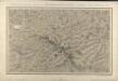
Meßtischblatt 3168 : Schotten, 1936

1 : 250000 Schotten. - Bearb. 1912, hrsg. 1914, Neuerkund. 1926, kleine Nachtr. 1932, Nadelabw. für Mitte 1936. - 1:25000. - [Wiesbaden]: Hess. Landesvermessungs- Amt, Haupt, 1936. - 1 Kt.
$title$

Meßtischblatt 3049 : Lingelbach, 1908

1 : 250000 Lingelbach. - Aufn. 1906. - 1:25000. - [Berlin]: Kgl. Preuss. Landesaufnahme, 1908. - 1 Kt.
$title$

Meßtischblatt 3227 : Neuhof, 1939

1 : 250000 Neuhof. - Hrsg. 1906, Ausg. 1939. - 1:25000. - [Berlin]: Reichsamt für Landesaufnahme, 1939. - 1 Kt.
$title$

Meßtischblatt 3227 : Neuhof, 1929

1 : 250000 Neuhof. - Hrsg. 1906, bericht. 1929. - 1:25000. - [Berlin]: Reichsamt für Landesaufnahme, 1929. - 1 Kt.
$title$

Meßtischblatt 3171, neue Nr. 5423 : Großenlüder, 1936

1 : 250000 Großenlüder. - Hrsg. 1907, bericht. 1910, einzelne Nachtr. 1930. - 1:25000. - [Berlin]: Reichsamt für Landesaufnahme, 1936. - 1 Kt.
$title$

Meßtischblatt 3112 : Salzschlirf, 1908

1 : 250000 Salzschlirf. - Aufn. 1906. - 1:25000. - [Berlin]: Kgl. Preuss. Landesaufnahme, 1908. - 1 Kt.
$title$

Meßtischblatt 5223 : Queck (Breitenbach a. Herzberge), 1926

1 : 250000 Queck (Breitenbach a. Herzberge). - Bearb. 1906 - 1907, Nachtr. 1926. - 1:25000. - [Berlin]: Reichsamt für Landesaufnahme, 1926. - 1 Kt.
$title$

Delineatio Geographica generalis comprehendens VI. Foliis Singulos Principatvs Comitatvs Ditiones Dynastias omnes quotquot Imperio Serenissimi Principis Landgrafii Hasso-Darmstadiensis subsunt :

1 : 180000 Mollova mapová sbírka Bronner, Christian Maximilian Homann, Johann Baptista - dědici
$title$

Section Giessen, uit: Charte von dem Grossherzogtum Hessen und dem Herzogtum Nassau / trigonometrisch aufgenommen und hrsg. von C.L.P. Eckhardt

1 : 200000 titelvariant: Karte von Hessen und Nassau Eckhardt, C. L. P Darmstadt : Joh. Wilh. Heyer
$title$

Hassiae Svperioris et Wetterav. Partis Delineatio

1 : 170000 Mollova mapová sbírka Bronner, Christian Maximilian Homann, Johann Baptista - dědici
$title$

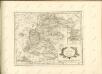
Wetteraviae Hanc Cum Confiniis Delineationem Serenissimo Principi Ac Domino, D[omi]no Ernesto Ludovico, Hassiae Landgravio, Principi Hersfeldiae, Comiti In Cattimeliboco, Decia, Ziegenhaina, Nidda, Schaumburg, Isemburgo Et Budinga, Etc. Domino suo clementißimo humilimè offert Ioh. Iacob Stetter, I. U. L.

Stetter, Johann Jakob; Stridbeck, Johann Hutter
$title$

Bewegungen der Alliirten, und Französischen Armee zwischen dem 19ten und 21ten März 1761, nebst Aufstellung und Rückzug der Alliirten am 23ten und 24ten

$title$

Landgrafiatvs Hasso-Cassellanvs typo geographico quatuor Foliorum expressus Cura Homannianorum Heredum Norimb: 1761

1 : 160000 Mollova mapová sbírka Homann, Johann Baptist Homann, Johann Baptista - dědici
$title$

Bvchaviae, siue Fvldensis ditionis typvs

1 Karte : Kupferdruck ; 30 x 21 cm Regerwyl; Ortelius s.n.
$title$

$title$

Le Landgraviat de Hesse-Cassel Meridional et Septentr: avec une Partie du Landgraviat de Hesse-Darmstat et de la Vetteravie avec autres dependences

1 : 200000 Mollova mapová sbírka Carlet, Louis-François Lotter, Tobias Conrad
$title$

125. Marburg, uit: Topographische Uebersichtskarte des Deutschen Reiches / herausgegeben v. d. Kartogr. Abt. d. Königl. Preuß. Landesaufnahme

1 : 200000 titelvariant: Topogr. Übersichtskarte des Deutschen Reiches; Annotatie: Titel boven bladen ook: Topogr. Übersichtskarte des Deutschen Reiches; Annotatie geografische gegevens: Op elk blad twee maatstokken: 10 Kilometer = 5,5 cm; 1 geogr. Meile = 3,6 cm; Legenda onder op elk blad Königlich Preußische Landesaufnahme. Kartographische Abtheilung [S.l : Königlich Preußische Landesaufnahme, Kartographische Abtheilung]
$title$

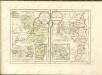
Territorium Abbatiae Heresfeldensis. 't Stift Hirßfeldt. [Karte], in: Le théâtre du monde, ou, Nouvel atlas contenant les chartes et descriptions de tous les païs de la terre, Bd. 1, S. 184.

1 Karte aus Atlas Blaeu, Willem Janszoon und Blaeu, Joan Blaeu, Willem Janszoon
$title$

Abbatia Heresfeldensis. vulgo 't Stifftt Hirsfeldt. [Karte], in: Gerardi Mercatoris et I. Hondii Newer Atlas, oder, Grosses Weltbuch, Bd. 1, S. 295.

1 Karte aus Atlas Mercator, Gerhard und Hondius, Jodocus Jansson, Jan
$title$

Territorium Abbatiae Heresfeldensis. 't Stift Hirszfeldt. [Karte], in: Novus Atlas, das ist, Weltbeschreibung, Bd. 1, S. 153.

1 Karte aus Atlas Blaeu, Joan Blaeu, Willem Janszoon
$title$

Territorium Abbatiae Heresfeldensis. 't Stift Hirßfeldt. [Karte], in: Novus atlas absolutissimus, Bd. 2, S. 171.

1 Karte aus Atlas Janssonius Offizin
$title$

Territorivm abbatiae Heresfeldensis = 't Stift Hirszfeldt

1 : 70000 titelvariant: 't Stift Hirszfeldt; Annotatie: Origineel is Blad 103 in atlas factice; Annotatie geografische gegevens: Schaalvermeldingen linksonder: Dimidium milliaris Haßici, en: Dimidium milliaris Germanici Willem Jansz Blaeu 1571-1638 [Amsterdami : apud Guiljelmum Blaeu]
$title$

Territorium Abbatiae Heresfeldensis. 't Stift Hirßfeldt. [Karte], in: Theatrum orbis terrarum, sive, Atlas novus, Bd. 1, S. 242.

1 Karte aus Atlas Blaeu, Joan Blaeu, Willem Janszoon
© MapTiler © OpenStreetMap contributors
How does it work?
These instructions will show you how to find historical maps online.
Getting started
Type the place name in the search box to find the exact location. You can further adjust the search by zooming in and out.
Zoom
Zoom in and out with the buttons or use your mouse or touchpad natively.
Exact Area tool
Click here and draw a rectangle over the map to precisely define the search area.
Set filters
Narrow your search with advanced settings, such as Years (from/to), Fulltext, Publisher, etc.
Results
See the results of your search on the right side. You can scroll down to find more maps of this location.
?

Download OldMapsOnline Mobile