Old maps of Jahnsdorf/Erzgebirge

Discover the past of Jahnsdorf/Erzgebirge on historical maps

Browse the old maps

Discovering the Cartography of the Past

Jahnsdorf/Erzgebirge


Parent places:

Maps of Jahnsdorf/Erzgebirge

Maps of Jahnsdorf/Erzgebirge

$title$

Meßtischblatt 113 : Stollberg, 1935

1 : 250000 Stollberg. - Umdr.-Ausg., aufgen. 1907/08, hrsg. 1909, bericht. 1925, einz. Nachtr. 1935. - 1:25000. - Leipzig, 1935. - 1 Kt.
$title$

Meßtischblatt 113 : Stollberg, 1919

1 : 250000 Stollberg. - Aufgen. 1907/08, hrsg. 1909, einz. Nachtr. 1919. - 1:25000. - Leipzig, 1919. - 1 Kt.
$title$

Meßtischblatt 114 : Burkhardtsdorf, 1938

1 : 250000 Burkhardtsdorf. - Umdr.-Ausg., aufgen. 1912/14 u. 1919/20, hrsg. 1927. - 1:25000. - Leipzig, 1938. - 1 Kt.
$title$

$title$

Mappa geographica regni Bohemiae in duodecim circulos divisae ...

$title$

Sebastianberg und Sachs. Annaberg.

from Spezialkarte der osterreichisch-ungarischen Monarchie.
$title$

Kahle's Höhenschichtenkarte des Erzgebirges

1 : 100000 Krušné hory (Česko a Německo) Hofbuchdruckerei H. Kahle
$title$

Die Aemter Freyberg und Frauenstein zu dem Ertzgebürgischen Creisse gehörig

1 : 290000 Frauenstein (Německo) Schreiber, Johann Georg bey Joh. George Schreibers See. Wittbe
$title$

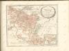
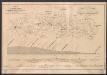
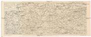
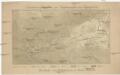
166 Zwickau, uit: Topographische Special-Karte von Deutschland (von Central-Europa) / begründet von D.G. Reymann ; [entworfen und gezeichn. von Heinrich Berghaus... [et al.]]

1 : 200000 Annotatie: Lit.: Daniel Gottlob Reymann und die "Topographische Special-Karte von Deutschland" / von Wolfgang Scharfe, in: Kartographische Nachrichten, 39 (1989), Heft I, p. 1-10; Handgeschreven titel: Reymann's Deutschland : 24 Sectionen: Jena, Penig, Dresden, Zittau, Hirschberg, Breslau, Brieg, Andernach, Coblenz, Giessen, Fulda, Schleusingen, Plauen, Zwickau, Teplitz, Jung Bunzlau, Hohenelbe, Glatz, Neisse, Simmern, Prag, Luxemburg, Birkenfeld; Aanwezig: 23 bladen Reymann, Daniel Gottlob; Berghaus, Heinrich [Berlin : 2. Departement des Kriegsministeriums, Bureau für Plan- und Kartenzeichnung]
$title$

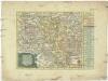
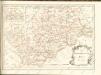
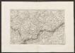
Accurate geographische Delineation derer graefflichen schönburgischen AEmter 1. Penig, 3 Remissa, 3. Rochsburg, 4. und Wechselburg, nebst der Grafschafft 5 Hartenstein, so alle chursachsische Lehn ferner der Herrschaften und AEmter 6. Glaucha, 7. Lichtenstein, 8. Stein, und 9. Waldenburg, so boehmisch Lehn und alle in der Bezirck des Amts Zwickau liegen

1 : 120000 Zwickau (Německo) Schenk, Pieter P. Schenk
$title$

Chemnitz

1 : 120000 Chemnitz-oblast (Německo) Kön. Kameral-Vermessung u. Graviranstalt
$title$

Accurate Geographische Delineation derer Graefflichen Schönburgischen Aemter oder Herrschafften

1 : 120000 Mollova mapová sbírka Schenk, Pieter Schenk, Peter II
$title$

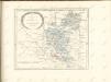
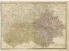
Dynastiae Comitatus Schoenburgici Penig, Remissa, Rochsburg, Wechselburg In Clientela Elect: Saxon Glaucha, Hartenstein, Lichtenst. Stein, Waldenburg

1 : 120000 Mollova mapová sbírka Seutter, Matthäus Lotter, Tobias Conrad Seutter, Matthäus
$title$

Comitatvs Schoenburgensis

1 : 120000 Mollova mapová sbírka Trenckmann, Johann P. Homann, Johann Baptista - dědici
$title$

$title$

129. Chemnitz, uit: Topographische Uebersichtskarte des Deutschen Reiches / herausgegeben v. d. Kartogr. Abt. d. Königl. Preuß. Landesaufnahme

1 : 200000 titelvariant: Topogr. Übersichtskarte des Deutschen Reiches; Annotatie: Titel boven bladen ook: Topogr. Übersichtskarte des Deutschen Reiches; Annotatie geografische gegevens: Op elk blad twee maatstokken: 10 Kilometer = 5,5 cm; 1 geogr. Meile = 3,6 cm; Legenda onder op elk blad Königlich Preußische Landesaufnahme. Kartographische Abtheilung [S.l : Königlich Preußische Landesaufnahme, Kartographische Abtheilung]
$title$

Mappa Geographica Circuli Metalliferi Electoratus Saxoniae cum omnibus, quae in eo comprehenduntur Praefecturis et Dynastiis

1 : 170000 Mollova mapová sbírka Lotter, Tobias Conrad Seutter, Matthäus
$title$

Mappa geographica circuli Metalliferi electoratus Saxoniae cum omnibus, quae in eo comprehenduntur praefecturis et dynastiis

Sasko (Německo) Seutter, Matthäus Lotter, Tobias Conrad M. Seutter
$title$

Grundriss und Profil der Chemnitz Riesaer Eisenbahn

1 : 120000 Lippe Lith. Anstalt von H. Jahn
$title$

Carte von Ertzgebürgischen Creysse in Churfurstenthum Sachssen

1 : 170000 Mollova mapová sbírka Schenk, Pieter Schenk, Peter I
$title$

$title$

Der Erzgebirgische Kreis

1 : 30000 Chemnitz-oblast (Německo) Riedig, Christian G. Leutemann, H. Schreibers Erben
$title$

Chemnitz 88, uit: Special-Karte von Mittel-Europa / nach amtlichen Quellen bearbeitet von W. Liebenow

1 : 300000 titelvariant: W. Liebenow's Mittel-Europa; Annotatie: Titel boven de bladen: W. Liebenow's Mittel-Europa Johannes Wilhelm Liebenow 1822-1897 Frankfurt a. M. : Ludwig Ravenstein
$title$

Terra Advocatorvm vulgo Voightland

1 : 290000 Vogtland (Německo) Örnehufvud, Olof Hansson Blaeu, Joan J. Blaeu
$title$

Rudohoří

1 : 288000 Krušné hory-oblast (Česko a Německo) Líčka, Josef Smrček, Antonín nákladem Františka Řivnáče
$title$

Karte des Saazer Kreises im Koenigreiche Boehmen

$title$

Elbogner dan Saatzer Kreis und Egerische = Gebiet

$title$

$title$

Orientirungskartchen zur Hydrographie des Egergebietes

Krušné hory (Česko a Německo)
$title$

Militair Karte von Süd-Deutschland in 20 Sectionen

1 : 400000 3. Section Coulon, Alois von A. von Coulon
© MapTiler © OpenStreetMap contributors
How does it work?
These instructions will show you how to find historical maps online.
Getting started
Type the place name in the search box to find the exact location. You can further adjust the search by zooming in and out.
Zoom
Zoom in and out with the buttons or use your mouse or touchpad natively.
Exact Area tool
Click here and draw a rectangle over the map to precisely define the search area.
Set filters
Narrow your search with advanced settings, such as Years (from/to), Fulltext, Publisher, etc.
Results
See the results of your search on the right side. You can scroll down to find more maps of this location.
?

Download OldMapsOnline Mobile