Old maps of Altenkirchen (Westerwald)

Discover the past of Altenkirchen (Westerwald) on historical maps

Browse the old maps

Discovering the Cartography of the Past

Altenkirchen (Westerwald)


Parent places:

Maps of Altenkirchen (Westerwald)

Maps of Altenkirchen (Westerwald)

$title$

Meßtischblatt 5311 : Altenkirchen im Westerwald, 1946

1 : 250000 Altenkirchen im Westerwald. - Hrsg. 1901, einz. Nachtr. 1928. - 1:25000. - Bad Godesberg : HVA, 19[46]. - 1 Kt.
$title$

Le Flambeau de la Guerre Allumee au Rhin

Mollova mapová sbírka Delisle, Guillaume Schenk, Peter II
$title$

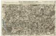
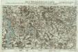
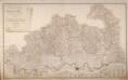
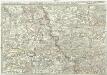
161 Coblenz, uit: Topographische Special-Karte von Deutschland (von Central-Europa) / begründet von D.G. Reymann ; [entworfen und gezeichn. von Heinrich Berghaus... [et al.]]

1 : 200000 Annotatie: Lit.: Daniel Gottlob Reymann und die "Topographische Special-Karte von Deutschland" / von Wolfgang Scharfe, in: Kartographische Nachrichten, 39 (1989), Heft I, p. 1-10; Handgeschreven titel: Reymann's Deutschland : 24 Sectionen: Jena, Penig, Dresden, Zittau, Hirschberg, Breslau, Brieg, Andernach, Coblenz, Giessen, Fulda, Schleusingen, Plauen, Zwickau, Teplitz, Jung Bunzlau, Hohenelbe, Glatz, Neisse, Simmern, Prag, Luxemburg, Birkenfeld; Aanwezig: 23 bladen Reymann, Daniel Gottlob; Berghaus, Heinrich [Berlin : 2. Departement des Kriegsministeriums, Bureau für Plan- und Kartenzeichnung]
$title$

124. Siegen, uit: Topographische Uebersichtskarte des Deutschen Reiches / herausgegeben v. d. Kartogr. Abt. d. Königl. Preuß. Landesaufnahme

1 : 200000 titelvariant: Topogr. Übersichtskarte des Deutschen Reiches; Annotatie: Titel boven bladen ook: Topogr. Übersichtskarte des Deutschen Reiches; Annotatie geografische gegevens: Op elk blad twee maatstokken: 10 Kilometer = 5,5 cm; 1 geogr. Meile = 3,6 cm; Legenda onder op elk blad Königlich Preußische Landesaufnahme. Kartographische Abtheilung [S.l : Königlich Preußische Landesaufnahme, Kartographische Abtheilung]
$title$

Section Weilburg, uit: Charte von dem Grossherzogtum Hessen und dem Herzogtum Nassau / trigonometrisch aufgenommen und hrsg. von C.L.P. Eckhardt

1 : 200000 titelvariant: Karte von Hessen und Nassau Eckhardt, C. L. P Darmstadt : Joh. Wilh. Heyer
$title$

Neue Topographische Carte Der Sieg und Agger von ihrem Ursprunge bis zu ihrem Einflus in den Rhein mit Bemerkung der in dieser Gegend vorgefallenen Kriegsbegebenheiten von 1795 und 1796

Brand, Peter; Schalck, Anna Maria; Coentgen, Georg Joseph Brand
$title$

Bonn und Cöln.

1 : 300000 Mollova mapová sbírka Person, Nikolaus Person, Nicolas
$title$

Wetzlar 85, uit: [W. Liebenow's Special-Karte von Mittel-Europa]

1 : 300000 titelvariant: W. Liebenow's Mittel-Europa; Annotatie: Titel boven de bladen: W. Liebenow's Mittel-Europa Johannes Wilhelm Liebenow 1822-1897 Hannover : Hermann Oppermann
$title$

Neue Topographische Carte Der Lahn von Marburg bis zu ihrem Einflus in den Rhein mit Bemerkung der in dieser Gegend vorgefallenen Kriegsbegebenheiten von 1795 und 1796

Brand, Peter; Thum, C.; Schalck, Anna Maria; Coentgen, Georg Joseph Brand u. Thum
$title$

Wetzlar 85, uit: Special-Karte von Mittel-Europa / nach amtlichen Quellen bearbeitet von W. Liebenow

1 : 300000 titelvariant: W. Liebenow's Mittel-Europa; Annotatie: Titel boven de bladen: W. Liebenow's Mittel-Europa Johannes Wilhelm Liebenow 1822-1897 Frankfurt a. M. : Ludwig Ravenstein
$title$

Le Duché de Berg, le Comté de Homberg, les Seugneries de Hardenberg, et de Wildenborg

1 : 230000 Mollova mapová sbírka Sanson, Guillaume Covens, Johannes I
$title$

Le Duché de Berg, le Comté de Homberg, les Seugneries de Hardenberg, et de Wildenborg

1 : 230000 Mollova mapová sbírka Sanson, Guillaume Jaillot, Alexis Hubert
$title$

Partie Orientale Du Temporel De L'Archevesché et Eslectorat, De Treves

1 : 210000 Mollova mapová sbírka Sanson, Guillaume Jaillot, Alexis Hubert
$title$

Nassau, Hessen-Homburg, Frankfurt.

1 : 344000 Flemming, Carl
$title$

Archiepiscopatus Coloniensis Pars Australis

1 : 260000 Mollova mapová sbírka Gigas, Johann Michael
$title$

Archiepiscopatus Coloniensis Pars Australis

1 : 260000 Mollova mapová sbírka Gigas, Johann Michael
$title$

$title$

$title$

Das Herzogthum Nassau

1 : 200000 Wimmer, Friedrich Scholz
$title$

Das Herzogthum Berg hat in die Länge 15 teutsche Meilen und in die dreite 7 =

1 : 690000 Mollova mapová sbírka Baeck, Elias Bäck, Elias
$title$

Nassovia Comitatvs

1 : 1300000 Mollova mapová sbírka Hondius, Henricus Hondius, Henricus
$title$

Topographisch-Militairische Karte Des Herzogthums Berg

Wiebeking, Carl Friedrich von; Bechstatt, I. C.
$title$

$title$

Berge Ducatus Marck Comitatus

1 : 240000 Mollova mapová sbírka Schenk, Pieter Schenk, Peter I
$title$

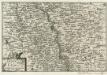
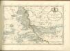
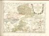
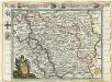
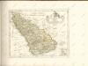
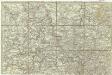
Le Duché De Berg, Le Comté De Homberg, Les Seigneuries De Hardenberg, Et De Wildenborg [Karte], in: Atlas nouveau, contenant toutes les parties du monde [...], Bd. 1, S. 222.

1 Karte aus Atlas Sanson, Nicolas Jaillot, Alexis Hubert und Mortier, Pieter
$title$

Exactissima totius Vederoviae late sumtae tabula, cujus pars prima est Vederovia stricte sic dicta versus meridiem

1 : 148000 Jülich (Německo) Buna, Wilhelm C.
$title$

[Exactissima totius Vederoviae late sumtae tabula, cujus pars prima est Vederovia stricte sic dicta versus meridiem]

1 : 148000 Jülich (Německo) Buna, Wilhelm C.
$title$

Das Herzogthum Nassau

1 : 438000 Weimar : Verlag des Geographischen Instituts
$title$

[21] Sec. Siegen, uit: Geologische Karte der Rheinprovinz und der Provinz Westphalen / ausgeführt durch H. von Dechen

1 : 80000 titelvariant: Dechen's geologische Karte vom Rheinland und Westphalen; Annotatie: Titel op bladoverzicht; Incompleet Heinrich von Dechen Berlin : Schropp
$title$

Charte vom Herzogthum Nassau

1 : 200000 Fembo, Christoph
© MapTiler © OpenStreetMap contributors
How does it work?
These instructions will show you how to find historical maps online.
Getting started
Type the place name in the search box to find the exact location. You can further adjust the search by zooming in and out.
Zoom
Zoom in and out with the buttons or use your mouse or touchpad natively.
Exact Area tool
Click here and draw a rectangle over the map to precisely define the search area.
Set filters
Narrow your search with advanced settings, such as Years (from/to), Fulltext, Publisher, etc.
Results
See the results of your search on the right side. You can scroll down to find more maps of this location.
?

Download OldMapsOnline Mobile