Old maps of Żelazno

Discover the past of Żelazno on historical maps

Browse the old maps

Discovering the Cartography of the Past

Żelazno


Parent places:

Maps of Żelazno

Maps of Żelazno

$title$

Meßtischblatt 3296 : Ullersdorf, 1936

1 : 250000 Ullersdorf. - Hrsg. 1884, bericht. 1919, gedr. [19]36. - 1:25000. - [Berlin]: Reichsamt für Landesaufnahme, 1936. - 1 Kt.
$title$

Meßtischblatt 3295 : Alt Lomnitz, 1936

1 : 250000 Alt Lomnitz. - Hrsg. 1884, bericht. 1919, gedr. [19]36. - 1:25000. - [Berlin]: Reichsamt für Landesaufnahme, 1936. - 1 Kt.
$title$

Meßtischblatt 3295 : Alt- Lomnitz, 1884

1 : 250000 Alt- Lomnitz. - Aufn. 1882. - 1:25000. - [Berlin]: Kgl. Preuss. Landesaufnahme, 1884. - 1 Kt.
$title$

Kronstadt a. d. Wilden Adler

1 : 75000 Kladsko (Polsko : oblast) Brunner K. u. k. militär-geographisches Institut
$title$

Kronstadt a. d. Wilden Adler

1 : 75000 Kladsko (Polsko : oblast) Brunner K. u. k. militär-geographisches Institut
$title$

Kronstadt a. d. Wilden Adler

1 : 75000 Kladsko (Polsko : oblast) Brunner K. u. k. Militärgeographisches Institut
$title$

Kronstadt a. d. Wilden Adler

1 : 75000 Čechy (Česko) K. u. k. Militärgeographisches Institut
$title$

Podrobná mapa Markrabství moravského a Vévodství slezkého

1 : 100000 Javorník (Jeseník, Česko : oblast) Srp, Jan Jos. R. Vilímek
$title$

Kronstadt a.d. Wilden Adler.; Spezialkarte der osterreichisch-ungarischen Monarchie.

from Spezialkarte der osterreichisch-ungarischen Monarchie. Austro-Hungarian Monarchy. Militärgeographisches Institut.,
$title$

$title$

III. vojenské mapování 3857

1 : 75000
$title$

Glatz

1 : 100000 Kladsko-oblast (Polsko) Petters, H.
$title$

Kunštát a Glatz

1 : 75000 Kladsko (Polsko : oblast) Vojenský zeměpisný ústav
$title$

Das Adlergebirge

Orlické hory (Česko a Polsko) Deutscher Gebirgsverein für das Adlergebirge
$title$

Podrobná mapa Markrabství moravského a Vévodství slezkého

1 : 100000 Králíky (Ústí nad Orlicí, Česko : oblast) Srp, Jan Jos. R. Vilímek
$title$

Blatt VII, uit: Geologisch-hydrographische Beschreibung des Niederschlagsgebietes der Glatzer-Neisse (oberhalb der Steinemündung) / A. Leppla ; hrsg. von der Königl. Preussischen geologischen Landesanstalt u. Bergakademie

Annotatie: Omslagtitel Königl. Preussische geologische Landesanstalt u. Bergakademie Berlin : Schropp
$title$

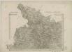
Plan des Angriffs, welcher unter dem ober Comando des kays. könig. Herrn Feldmarschall Lieutenants Grafen v. Wurmser, auf Habelschwerd, u. dem Blokhaus zu Oberschwedeldorffen in der Grafschafft Glaz den 18 Ien[n]er 1779 glücklich vollzogen worden

Kladská Bystřice (Polsko) Marinville, de Will, Johann Martin Ioh. Martin Will
$title$

Blatt I, uit: Geologisch-hydrographische Beschreibung des Niederschlagsgebietes der Glatzer-Neisse (oberhalb der Steinemündung) / A. Leppla ; hrsg. von der Königl. Preussischen geologischen Landesanstalt u. Bergakademie

Annotatie: Omslagtitel Königl. Preussische geologische Landesanstalt u. Bergakademie Berlin : Schropp
$title$

Orlické hory

$title$

Orlické hory

$title$

II. vojenské mapování 1

1 : 144000
$title$

170 Glatz, uit: Topographische Special-Karte von Deutschland (von Central-Europa) / begründet von D.G. Reymann ; [entworfen und gezeichn. von Heinrich Berghaus... [et al.]]

1 : 200000 Annotatie: Lit.: Daniel Gottlob Reymann und die "Topographische Special-Karte von Deutschland" / von Wolfgang Scharfe, in: Kartographische Nachrichten, 39 (1989), Heft I, p. 1-10; Handgeschreven titel: Reymann's Deutschland : 24 Sectionen: Jena, Penig, Dresden, Zittau, Hirschberg, Breslau, Brieg, Andernach, Coblenz, Giessen, Fulda, Schleusingen, Plauen, Zwickau, Teplitz, Jung Bunzlau, Hohenelbe, Glatz, Neisse, Simmern, Prag, Luxemburg, Birkenfeld; Aanwezig: 23 bladen Reymann, Daniel Gottlob; Berghaus, Heinrich [Berlin : 2. Departement des Kriegsministeriums, Bureau für Plan- und Kartenzeichnung]
$title$

Die Grafschaft Glatz

1 : 460000 Kladsko (Polsko : oblast) Schreiber, Johann Georg J.G. Schreibern
$title$

Orlické hory

1 : 100000 Orlické hory-oblast (Česko a Polsko) Pták, J. Kratěna, J. nákladem odboru K. Čs. T.
$title$

145. Glatz, uit: Topographische Uebersichtskarte des Deutschen Reiches / herausgegeben v. d. Kartogr. Abt. d. Königl. Preuß. Landesaufnahme

1 : 200000 titelvariant: Topogr. Übersichtskarte des Deutschen Reiches; Annotatie: Titel boven bladen ook: Topogr. Übersichtskarte des Deutschen Reiches; Annotatie geografische gegevens: Op elk blad twee maatstokken: 10 Kilometer = 5,5 cm; 1 geogr. Meile = 3,6 cm; Legenda onder op elk blad Königlich Preußische Landesaufnahme. Kartographische Abtheilung [S.l : Königlich Preußische Landesaufnahme, Kartographische Abtheilung]
$title$

Die souveraine Graffschaft Glatz an der Schlesischen Gräntze

Kladsko-oblast (Polsko) Schleuen, Johann David I.D. Schleuen
$title$

$title$

Monumenta Cartographica Bohemiae II.: Müllerova mapa

$title$

Kladsko

1 : 200000 Kladsko-oblast (Polsko) Service cartogr. de l ́Armee Tcheco-Sl.
$title$

Jeseníky

© MapTiler © OpenStreetMap contributors
How does it work?
These instructions will show you how to find historical maps online.
Getting started
Type the place name in the search box to find the exact location. You can further adjust the search by zooming in and out.
Zoom
Zoom in and out with the buttons or use your mouse or touchpad natively.
Exact Area tool
Click here and draw a rectangle over the map to precisely define the search area.
Set filters
Narrow your search with advanced settings, such as Years (from/to), Fulltext, Publisher, etc.
Results
See the results of your search on the right side. You can scroll down to find more maps of this location.
?

Download OldMapsOnline Mobile