Documento
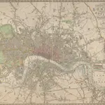
NEW PLAN OF LONDON AND THE ENVIRONS from an Original Survey EXTENDING 6 3/4 Miles North & South in which all New and Intended Buildings and Improvements are carefully Inserted
This folding map is set within a decorative border. The title and imprint feature at top right, the compass star at middle right, and scale bar at bottom left. The river, open spaces and the built-up area in the city are delineated in colour. This is the fourth edition of a map first issued by Thompson in 1823, updated with the addition of St. Katherine's Dock and the housing developments in the Marylebone and Mile End areas.
British LibraryThompson, George
1823