Mappa catalogata
The Virgin Islands from English and Danish surveys
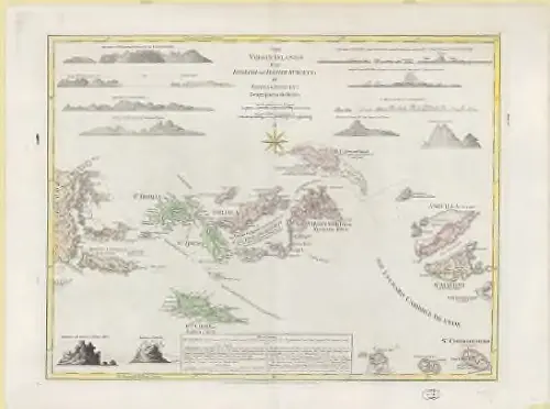

Istituzione:Harvard Library
Titolo completo:The Virgin Islands from English and Danish surveys
Anno di illustrazione:1775
Data di pubblicazione:1775
Editore:Printed for Robt. Sayer, Map & Printseller, no. 53 in Fleet Street, as the Act directs
Scala della mappa:1:490 000

Nieuwe en aldereerste afteekening van 't eyland St. Thomas, met alle desselfs havenen, anker plaatse en geleegentheden is geleegen beoosten I. Porto Rico in West Indie behoorende aan syn Koninklyke Majestyt van Denemarken, dit Eyland geeft Catoen...
1719
1:40k

St. Thomas
1922
1:40k

Eil. St. Vincent
1785

Eil. Dominiko
1785

Eil. St. Christoffel
1785

Aanhangsel tot de Antilles eilanden, uit de Engelsche kaarten getrokken
1785

Eil. Barbados
1785

Supplement pour les Isles Antilles, extrait des carte Angloises
1780
1:1m
The Virgin Islands from English and Danish surveys
1775
Jefferys, Thomas, d. 1771
1:490k

Plan of Peters Island [inset]
1802
Thomas Jefferys (-1771)