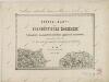
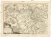
Combat de Moys, dans la Haute Lusace, gagné par les troupes impériales, aux ordres du duc d'Aremberg et du général de Nadasti, sur un corps détaché des Prussiens, commandé par le lieutenant général de Winterfeld, le 7. septembre, 1757
1 : 19500
Görlitz (Německo)
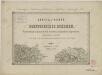
Combat de Moys, dans la Haute Lusace, gagné par les troupes impériales, aux ordres du duc d'Aremberg et du général de Nadasti, sur un corps détaché des Prussiens, commandé par le lieutenant général de Winterfeld, le 7. septembre, 1757
1 : 19500
Görlitz (Německo)

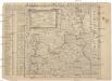
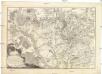
149 Zittau, uit: Topographische Special-Karte von Deutschland (von Central-Europa) / begründet von D.G. Reymann ; [entworfen und gezeichn. von Heinrich Berghaus... [et al.]]
1 : 200000
Annotatie: Lit.: Daniel Gottlob Reymann und die "Topographische Special-Karte von Deutschland" / von Wolfgang Scharfe, in: Kartographische Nachrichten, 39 (1989), Heft I, p. 1-10; Handgeschreven titel: Reymann's Deutschland : 24 Sectionen: Jena, Penig, Dresden, Zittau, Hirschberg, Breslau, Brieg, Andernach, Coblenz, Giessen, Fulda, Schleusingen, Plauen, Zwickau, Teplitz, Jung Bunzlau, Hohenelbe, Glatz, Neisse, Simmern, Prag, Luxemburg, Birkenfeld; Aanwezig: 23 bladen
Reymann, Daniel Gottlob; Berghaus, Heinrich
[Berlin : 2. Departement des Kriegsministeriums, Bureau für Plan- und Kartenzeichnung]