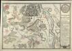
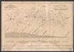
147 Penig, uit: Topographische Special-Karte von Deutschland (von Central-Europa) / begründet von D.G. Reymann ; [entworfen und gezeichn. von Heinrich Berghaus... [et al.]]
1 : 200000
Annotatie: Lit.: Daniel Gottlob Reymann und die "Topographische Special-Karte von Deutschland" / von Wolfgang Scharfe, in: Kartographische Nachrichten, 39 (1989), Heft I, p. 1-10; Handgeschreven titel: Reymann's Deutschland : 24 Sectionen: Jena, Penig, Dresden, Zittau, Hirschberg, Breslau, Brieg, Andernach, Coblenz, Giessen, Fulda, Schleusingen, Plauen, Zwickau, Teplitz, Jung Bunzlau, Hohenelbe, Glatz, Neisse, Simmern, Prag, Luxemburg, Birkenfeld; Aanwezig: 23 bladen
Reymann, Daniel Gottlob; Berghaus, Heinrich
[Berlin : 2. Departement des Kriegsministeriums, Bureau für Plan- und Kartenzeichnung]

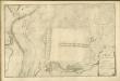
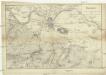
Exacta Delineatio Geographica omnium Electoratus Saxonici Circulo Lipsiensi appartenentium Praefecturarum Colditium, Leissnigium, Rochlitium, Praefectura Portae Grimmensis una cum pluribus aliis finitimis Praefecturis
1 : 120000
Mollova mapová sbírka
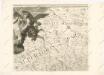
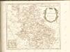
Seutter, Matthäus
Lotter, Tobias Conrad
Seutter, Matthäus

Accurate geographische Delineation derer in dem Churfürstenthum Sachsen, gelegenen und zum leipziger Creisse gehörigen Aemmter Coldiz, Leissing, Rochliz, und Schul-Ammt Grimma ingleichen Mügel und Sornzig, samt vielen andern angrentzenden Aemtern
1 : 119000
Colditz (Německo)
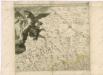
Schenk, Pieter
P. Schenk