Old maps of gmina Kąty Wrocławskie

Discover the past of gmina Kąty Wrocławskie on historical maps

Browse the old maps

Discovering the Cartography of the Past

gmina Kąty Wrocławskie


Parent places:

Related places:

City

Maps of gmina Kąty Wrocławskie

Maps of gmina Kąty Wrocławskie

$title$

Meßtischblatt 2890 : Kanth, 1936

1 : 250000 Kanth. - Hrsg. 1889, bericht. 1932, einz. Nachtr. 1936. - 1:25000. - [Berlin]: Reichsamt für Landesaufnahme, 1936. - 1 Kt.
$title$

Meßtischblatt 2890 : Canth, 1889

1 : 250000 Canth. - Aufn. 1887. - 1:25000. - [Berlin]: Reichsamt für Landesaufnahme, 1889. - 1 Kt.
$title$

Meßtischblatt 2891 :Schmolz, 1936

1 : 250000 Schmolz. - Hrsg. 1886, bericht. 1926, einz. Nachtr. 1936. - 1:25000. - [Berlin]: Reichsamt für Landesaufnahme, 1936. - 1 Kt.
$title$

Meßtischblatt 2891 : Schmolz, 1934

1 : 250000 Schmolz. - Hrsg. 1886, bericht. 1926, Nachtr. 1934. - 1:25000. - [Berlin]: Reichsamt für Landesaufnahme, 1934. - 1 Kt.
$title$

Meßtischblatt 2891 : Schmolz, 1914

1 : 250000 Schmolz. - Aufn. 1885, hrsg. 1886, Aufldr. 1914. - 1:25000. - [Berlin]: Reichsamt für Landesaufnahme, 1914. - 1 Kt.
$title$

Schlacht bey Breslau in Schlesien am 22ten November 1754

Vratislav (Polsko)
$title$

Meßtischblatt 5066 : Rosenborn, 1943

1 : 250000 Rosenborn. - Aufn. 1883, hrsg. 1884, bericht. 1940, Ausg. 1943. - 1:25000. - [Berlin]: Reichsamt für Landesaufnahme, 1943. - 1 Kt.
$title$

Meßtischblatt 2953 : Mörschelwitz, 1884

1 : 250000 Mörschelwitz. - Aufn. 1883. - 1:25000. - [Berlin]: Kgl. Preuss. Landesaufnahme, 1884. - 1 Kt.
$title$

Meßtischblatt 5067 : Rößlingen, 1938

1 : 250000 Rößlingen. - Hrsg. 1884, bericht. 1930, einz. Nachtr. 1932, redakt. Änd. [19]38. - 1:25000. - [Berlin]: Reichsamt für Landesaufnahme, 1938. - 1 Kt.
$title$

Grundriß der schlesischen Hauptstadt Bresslau

1 : 142000 Vratislav-oblast (Polsko) Trattner, Johann Thomas Johann Thomas Trattner
$title$

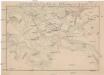
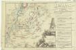
151 Breslau, uit: Topographische Special-Karte von Deutschland (von Central-Europa) / begründet von D.G. Reymann ; [entworfen und gezeichn. von Heinrich Berghaus... [et al.]]

1 : 200000 Annotatie: Lit.: Daniel Gottlob Reymann und die "Topographische Special-Karte von Deutschland" / von Wolfgang Scharfe, in: Kartographische Nachrichten, 39 (1989), Heft I, p. 1-10; Handgeschreven titel: Reymann's Deutschland : 24 Sectionen: Jena, Penig, Dresden, Zittau, Hirschberg, Breslau, Brieg, Andernach, Coblenz, Giessen, Fulda, Schleusingen, Plauen, Zwickau, Teplitz, Jung Bunzlau, Hohenelbe, Glatz, Neisse, Simmern, Prag, Luxemburg, Birkenfeld; Aanwezig: 23 bladen Reymann, Daniel Gottlob; Berghaus, Heinrich [Berlin : 2. Departement des Kriegsministeriums, Bureau für Plan- und Kartenzeichnung]
$title$

Wege - Karte der Gegend um Breslau

$title$

Das Fürstenthum Bresslau in Nieder-Schlesien

1 : 720000 Vratislav-oblast (Polsko) Schleuen, Johann David Schleuen
$title$

Das Fürstenthum Bresslau in Nieder-Schlesien

1 : 458300 Mollova mapová sbírka Schleuen, Johann David
$title$

Das Fürstenthum Schweidnitz

1 : 130000 Slezsko Sotzmann, Daniel Friedrich Fembo, Christoph Christoph Fembo
$title$

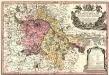
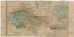
Principtus Silesiae Wratislaviensis exactissima Tabula Geographica sistens simul Circulum Neoforensem et Districtum Cantiensem, ac status minores vulgo Burglehn dictos Lissa, Kraicka, Weigwitz, Rommenau, Krolkwitz, Bogenau, Malckwitz, Auras, Gr. Peterwitz et Halt Grosburg

1 : 120000 Mollova mapová sbírka Wieland, Johann Wolfgang Homann, Johann Christoph
$title$

Principatus Silesiae Wratislaviensis :

1 : 120000 Mollova mapová sbírka Wieland, Johann Wolfgang Homann, Johann Baptista - dědici
$title$

Ducatus Breslanus sive Wratislaviensis

1 : 240000 Mollova mapová sbírka Aveele, Johannes van den Schenk, Peter I
$title$

Dvcatvs Breslanvs sive Wratislaviensis

1 : 220000 Mollova mapová sbírka Vechner, Georg Blaeu, Joan I.
$title$

119. Breslau, uit: Topographische Uebersichtskarte des Deutschen Reiches / herausgegeben v. d. Kartogr. Abt. d. Königl. Preuß. Landesaufnahme

1 : 200000 titelvariant: Topogr. Übersichtskarte des Deutschen Reiches; Annotatie: Titel boven bladen ook: Topogr. Übersichtskarte des Deutschen Reiches; Annotatie geografische gegevens: Op elk blad twee maatstokken: 10 Kilometer = 5,5 cm; 1 geogr. Meile = 3,6 cm; Legenda onder op elk blad Königlich Preußische Landesaufnahme. Kartographische Abtheilung [S.l : Königlich Preußische Landesaufnahme, Kartographische Abtheilung]
$title$

Plan der Bataille bey Breslau...

$title$

Plan der Bataille von Leuthen ohnweit Lissa in Schlesien zwischen der Kayserl. Königl. und Königl. Preusischen Armee den 5. Dec. 1757 vorgefallen

1 : 50000 Back, Jakob Conrad; Brönner, Heinrich Ludwig zu finden bey H. L. Brönner auf dem Pfareyssen
$title$

Plan der Schlacht bei Breslau am 22ten November 1757

1 : 25000 Boromski, A.
$title$

Plan de la bataille de Breslau

1 : 20000 Vratislav-oblast (Polsko) Logis, de chez Jean-Thomas Trattner
$title$

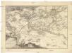
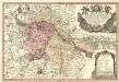
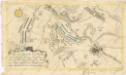
Schlacht bey Breslau, in Schlesien, welche den 22. November. 1757. von der kayserlichen Armee, unter Anführung des Prinzen Carls von Lothringen, gegen des preussischen General, Prinz von Bevern, gewonnen worden

1 : 42000 Vratislav-oblast (Polsko)
$title$

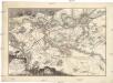
Bataille de Breslau, en Silesie, gagnée par l'armée impériale, aux ordres du prince Charles de Lorraine, sur celles des Prussiens commandée par le prince de Bevern, le 22. novembre, 1757

1 : 42000 Vratislav-oblast (Polsko)
$title$

Schlacht bey Breslau, in Schlesien, welche den 22. November 1757 von der kayserlichen Armee, unter Anführung des Prinzen Carls von Lothringen, gegen den preussischen General, Prinz von Bevern, gewonnen worden.

Vratislav (Polsko) Cappi, Carlo Le Rouge, Georges-Louis
$title$

Plan de la bataille pres de Leuthen en Silesie le 5. decembre 1757

Lutynia (Polsko) Beaulieu Trattner, Johann Thomas Jean Thomas Trattner
$title$

Meßtischblatt 2826 : Leuthen, 1938

1 : 250000 Leuthen. - Hrsg. 1889, bericht. 1927, einz. Nachtr. 1932, redakt. Änd. [19]38. - 1:25000. - [Berlin]: Reichsamt für Landesaufnahme, 1938. - 1 Kt.
$title$

Meßtischblatt 2826 : Leuthen, 1889

1 : 250000 Leuthen. - Aufn. 1887. - 1:25000. - [Berlin]: Reichsamt für Landesaufnahme, 1889. - 1 Kt.
© MapTiler © OpenStreetMap contributors
How does it work?
These instructions will show you how to find historical maps online.
Getting started
Type the place name in the search box to find the exact location. You can further adjust the search by zooming in and out.
Zoom
Zoom in and out with the buttons or use your mouse or touchpad natively.
Exact Area tool
Click here and draw a rectangle over the map to precisely define the search area.
Set filters
Narrow your search with advanced settings, such as Years (from/to), Fulltext, Publisher, etc.
Results
See the results of your search on the right side. You can scroll down to find more maps of this location.
?

Download OldMapsOnline Mobile