Old maps of gmina Kobierzyce

Discover the past of gmina Kobierzyce on historical maps

Browse the old maps

Discovering the Cartography of the Past

gmina Kobierzyce


Parent places:

Maps of gmina Kobierzyce

Maps of gmina Kobierzyce

$title$

Meßtischblatt 5067 : Rößlingen, 1938

1 : 250000 Rößlingen. - Hrsg. 1884, bericht. 1930, einz. Nachtr. 1932, redakt. Änd. [19]38. - 1:25000. - [Berlin]: Reichsamt für Landesaufnahme, 1938. - 1 Kt.
$title$

Meßtischblatt 2891 :Schmolz, 1936

1 : 250000 Schmolz. - Hrsg. 1886, bericht. 1926, einz. Nachtr. 1936. - 1:25000. - [Berlin]: Reichsamt für Landesaufnahme, 1936. - 1 Kt.
$title$

Meßtischblatt 2891 : Schmolz, 1934

1 : 250000 Schmolz. - Hrsg. 1886, bericht. 1926, Nachtr. 1934. - 1:25000. - [Berlin]: Reichsamt für Landesaufnahme, 1934. - 1 Kt.
$title$

Meßtischblatt 2891 : Schmolz, 1914

1 : 250000 Schmolz. - Aufn. 1885, hrsg. 1886, Aufldr. 1914. - 1:25000. - [Berlin]: Reichsamt für Landesaufnahme, 1914. - 1 Kt.
$title$

Meßtischblatt 5167 : Jordansmühl, 1938

1 : 250000 Jordansmühl. - Hrsg. 1884, bericht. 1932, redakt. Änd. [19]38. - 1:25000. - [Berlin]: Reichsamt für Landesaufnahme, 1938. - 1 Kt.
$title$

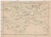
Meßtischblatt 3015, neue Nr. 5166 : Zobten am Berge, 1938

1 : 250000 Zobten am Berge. - Hrsg. 1883, bericht. 1925, einz. Nachtr. 1932, redakt. Änd. [19]38. - 1:25000. - [Berlin]: Reichsamt für Landesaufnahme, 1938. - 1 Kt.
$title$

Grundriß der schlesischen Hauptstadt Bresslau

1 : 142000 Vratislav-oblast (Polsko) Trattner, Johann Thomas Johann Thomas Trattner
$title$

151 Breslau, uit: Topographische Special-Karte von Deutschland (von Central-Europa) / begründet von D.G. Reymann ; [entworfen und gezeichn. von Heinrich Berghaus... [et al.]]

1 : 200000 Annotatie: Lit.: Daniel Gottlob Reymann und die "Topographische Special-Karte von Deutschland" / von Wolfgang Scharfe, in: Kartographische Nachrichten, 39 (1989), Heft I, p. 1-10; Handgeschreven titel: Reymann's Deutschland : 24 Sectionen: Jena, Penig, Dresden, Zittau, Hirschberg, Breslau, Brieg, Andernach, Coblenz, Giessen, Fulda, Schleusingen, Plauen, Zwickau, Teplitz, Jung Bunzlau, Hohenelbe, Glatz, Neisse, Simmern, Prag, Luxemburg, Birkenfeld; Aanwezig: 23 bladen Reymann, Daniel Gottlob; Berghaus, Heinrich [Berlin : 2. Departement des Kriegsministeriums, Bureau für Plan- und Kartenzeichnung]
$title$

Wege - Karte der Gegend um Breslau

$title$

Das Fürstenthum Bresslau in Nieder-Schlesien

1 : 720000 Vratislav-oblast (Polsko) Schleuen, Johann David Schleuen
$title$

Das Fürstenthum Bresslau in Nieder-Schlesien

1 : 458300 Mollova mapová sbírka Schleuen, Johann David
$title$

Das Fürstenthum Schweidnitz

1 : 130000 Slezsko Sotzmann, Daniel Friedrich Fembo, Christoph Christoph Fembo
$title$

Plan der Bataille bey Breslau...

$title$

Schlacht bey Breslau in Schlesien am 22ten November 1754

Vratislav (Polsko)
$title$

Meßtischblatt 5068 : Rothbach, 1941

1 : 250000 Rothbach. - Aufn. 1883, hrsg. 1885, bericht. 1930, letzte Nachtr. 1938. - 1:25000. - [Berlin]: Reichsamt für Landesaufnahme, 1941. - 1 Kt.
$title$

Meßtischblatt 2955 : Rothbach, 1937

1 : 250000 Rothbach. - Hrsg. 1885, bericht. 1930, einz. Nachtr. 1932, gedr. [19]37. - 1:25000. - [Berlin]: Reichsamt für Landesaufnahme, 1937. - 1 Kt.
$title$

Plan der Schlacht bei Breslau am 22ten November 1757

1 : 25000 Boromski, A.
$title$

[Manoeuvre bey Ohlau]

$title$

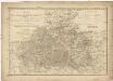
Meßtischblatt 2892, neue Nr. 4968 : Breslau, 1938

1 : 250000 Breslau. - Hrsg. 1886, bericht. 1926, einz. Nachtr. 1934, redakt. Änd. [19]38. - 1:25000. - [Berlin]: Reichsamt für Landesaufnahme, 1938. - 1 Kt.
$title$

Meßtischblatt 2892 : Breslau, 1937

1 : 250000 Breslau. - Hrsg. 1886, bericht. 1926, einz. Nachtr. 1934, gedr. [19]37. - 1:25000. - [Berlin]: Reichsamt für Landesaufnahme, 1937. - 1 Kt.
$title$

Meßtischblatt 2892 : Breslau, 1913

1 : 250000 Breslau. - Aufn. 1885, hrsg. 1886, Aufl.-dr. 1913. - 1:25000. - [Berlin]: Reichsamt für Landesaufnahme, 1913. - 1 Kt.
$title$

Meßtischblatt 3017 : Wäldchen, 1937

1 : 250000 Wäldchen. - Hrsg. 1885, bericht. 1932, gedr. [19]37. - 1:25000. - [Berlin]: Reichsamt für Landesaufnahme, 1937. - 1 Kt.
$title$

Meßtischblatt 3017 : Wäldchen, 1885

1 : 250000 Wäldchen. - Aufn. 1883. - 1:25000. - [Berlin]: Kgl- Preuss. Landesaufnahme, 1885. - 1 Kt.
$title$

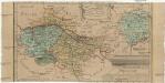
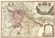
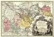
Principtus Silesiae Wratislaviensis exactissima Tabula Geographica sistens simul Circulum Neoforensem et Districtum Cantiensem, ac status minores vulgo Burglehn dictos Lissa, Kraicka, Weigwitz, Rommenau, Krolkwitz, Bogenau, Malckwitz, Auras, Gr. Peterwitz et Halt Grosburg

1 : 120000 Mollova mapová sbírka Wieland, Johann Wolfgang Homann, Johann Christoph
$title$

Principatus Silesiae Wratislaviensis :

1 : 120000 Mollova mapová sbírka Wieland, Johann Wolfgang Homann, Johann Baptista - dědici
$title$

Ducatus Breslanus sive Wratislaviensis

1 : 240000 Mollova mapová sbírka Aveele, Johannes van den Schenk, Peter I
$title$

Dvcatvs Breslanvs sive Wratislaviensis

1 : 220000 Mollova mapová sbírka Vechner, Georg Blaeu, Joan I.
$title$

$title$

Das Fürstenthum Brieg in Nieder-Schlesien

1 : 460000 Dolní Slezsko Schleuen, Johann David I.D. Schleuen
$title$

Principatvs Silesiae Bregensis

1 : 145000 Mollova mapová sbírka Wieland, Johann Wolfgang Homann, Johann Baptista - dědici
© MapTiler © OpenStreetMap contributors
How does it work?
These instructions will show you how to find historical maps online.
Getting started
Type the place name in the search box to find the exact location. You can further adjust the search by zooming in and out.
Zoom
Zoom in and out with the buttons or use your mouse or touchpad natively.
Exact Area tool
Click here and draw a rectangle over the map to precisely define the search area.
Set filters
Narrow your search with advanced settings, such as Years (from/to), Fulltext, Publisher, etc.
Results
See the results of your search on the right side. You can scroll down to find more maps of this location.
?

Download OldMapsOnline Mobile