Old maps of Jedlina-Zdrój

Discover the past of Jedlina-Zdrój on historical maps

Browse the old maps

Discovering the Cartography of the Past

Jedlina-Zdrój


Parent places:

Maps of Jedlina-Zdrój

Maps of Jedlina-Zdrój

$title$

[Kartenblatt]

1 : 25000 Broumov (Náchod, Česko : oblast) Reichsamt für Landesaufnahme
$title$

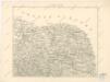
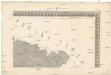
Meßtischblatt 3074, neue Nr. 5264 : Bad Charlottenbrunn, 1939

1 : 250000 Bad Charlottenbrunn. - Aufn. 1881, hrsg. 1883, bericht. 1937, redakt. Änd. [19]38. - 1:25000. - [Berlin]: Reichsamt für Landesaufnahme, 1939. - 1 Kt.
$title$

Meßtischblatt 3073 : Waldenburg in Niederschlesien, 1934

1 : 250000 Waldenburg in Niederschlesien. - Hrsg. 1884, bericht. 1925, einz. Nachtr. 1930, gedr. [19]34. - 1:25000. - [Berlin]: Reichsamt für Landesaufnahme, 1934. - 1 Kt.
$title$

Meßtischblatt 3073 : Waldenburg in Niederschlesien, 1907

1 : 250000 Waldenburg in Niederschlesien. - Aufn. 1884, hrsg. 1886, bericht. 1907. - 1:25000. - [Berlin]: Kgl. Preuss. Landesaufnahme, 1907. - 1 Kt.
$title$

Meßtischblatt 3012 : Freiburg in Schlesien, 1907

1 : 250000 Freiburg in Schlesien. - Aufn. 1884, hrsg. 1886, bericht. 1907. - 1:25000. - [Berlin]: Kgl. Preuss. Landesaufnahme, 1907. - 1 Kt.
$title$

Podrobná mapa Království českého

1 : 100000 Broumov (Náchod, Česko : oblast) Srp, Jan Jaroslav Bursík
$title$

Podrobná místopisná mapa Království Českého

$title$

Specialkarte des Riesengebirges

1 : 75000 Krkonoše (Česko a Polsko : pohoří : oblast) Section Riesengebirge des Gebirgvereines für Böhmen
$title$

Schonau Bei Bhm. Braunau.

from Spezialkarte der osterreichisch-ungarischen Monarchie.
$title$

Trautenau und Politz.

from Spezialkarte der osterreichisch-ungarischen Monarchie.
$title$

Generalkarte der Bezirkshauptmannschaft Braunau

1 : 220000 Broumov-oblast (Náchod, Česko) Wagner, Jan Eduard F. Kytka
$title$

Sec. Waldenburg

1 : 100000 Königliches Lithographisches Institut (Berlin) Simon Schroppsche Landkartenhndl.
$title$

Das Fürstenthum Schweidnitz in Nieder-Schlesien

1 : 290000 Svídnice-oblast (Polsko) Wieland, Johann Wolfgang Schleuen, Johann David I.D. Schleuen
$title$

Das Fürstenthum Schweidnitz in Nieder Schlesien

1 : 300000 Mollova mapová sbírka Schleuen, Johann David Schleuen, Johann David
$title$

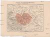
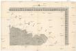
170 Glatz, uit: Topographische Special-Karte von Deutschland (von Central-Europa) / begründet von D.G. Reymann ; [entworfen und gezeichn. von Heinrich Berghaus... [et al.]]

1 : 200000 Annotatie: Lit.: Daniel Gottlob Reymann und die "Topographische Special-Karte von Deutschland" / von Wolfgang Scharfe, in: Kartographische Nachrichten, 39 (1989), Heft I, p. 1-10; Handgeschreven titel: Reymann's Deutschland : 24 Sectionen: Jena, Penig, Dresden, Zittau, Hirschberg, Breslau, Brieg, Andernach, Coblenz, Giessen, Fulda, Schleusingen, Plauen, Zwickau, Teplitz, Jung Bunzlau, Hohenelbe, Glatz, Neisse, Simmern, Prag, Luxemburg, Birkenfeld; Aanwezig: 23 bladen Reymann, Daniel Gottlob; Berghaus, Heinrich [Berlin : 2. Departement des Kriegsministeriums, Bureau für Plan- und Kartenzeichnung]
$title$

Krkonoše

Krkonoše (Česko a Polsko) Kohut, Josef Líčka, Josef nákladem Františka Řivnáče
$title$

Dvcatvs Silesiae Schwidnicensis

1 : 172500 Mollova mapová sbírka Kuhn, Friedrich Schenk, Peter I
$title$

Principatvs Silesiae Schwidnicensis Secundum ejusdem Circvlos Schweidnitz, Striegav, Bolckenhain, Landeshut & Reichenbach divisi et Geometr.

1 : 125000 Mollova mapová sbírka Wieland, Johann Wolfgang Homann, Johann Baptista - dědici
$title$

Monumenta Cartographica Bohemiae II.: Müllerova mapa

$title$

Das Fürstenthum Schweidnitz

1 : 130000 Slezsko Sotzmann, Daniel Friedrich Fembo, Christoph Christoph Fembo
$title$

[Nová Mapa království Českého]

1 : 200000 Krkonoše (Česko a Polsko) Kotyška, Václav Hanf, Norbert Bursík & Kohout
$title$

Nová Mapa království Českého

1 : 200000 Čechy severovýchodní (Česko) Kotyška, Václav Hanf, Norbert Bursík & Kohout
$title$

COMITATVS | GLATZ

Authore Jona Sculteto. [Amsterdam : Joan Blaeu]
$title$

Müllerova mapa Čech

1 : 132000
$title$

$title$

[Glatz]

Kladsko-oblast (Polsko) Kreibich, František Jakub Jindřich
$title$

$title$

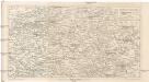
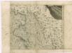
Comitatus Glatz [Karte], in: Le théâtre du monde, ou, Nouvel atlas contenant les chartes et descriptions de tous les païs de la terre, Bd. 1, S. 216.

1 Karte aus Atlas Blaeu, Willem Janszoon und Blaeu, Joan Blaeu, Willem Janszoon
$title$

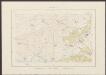
Comitatus Glatz [Karte], in: Novus Atlas, das ist, Weltbeschreibung, Bd. 1, S. 185.

1 Karte aus Atlas Blaeu, Joan Blaeu, Willem Janszoon
$title$

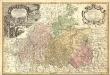
Comitatus Glatz [Karte], in: Theatrum orbis terrarum, sive, Atlas novus, Bd. 1, S. 150.

1 Karte aus Atlas Blaeu, Joan Blaeu, Willem Janszoon
© MapTiler © OpenStreetMap contributors
How does it work?
These instructions will show you how to find historical maps online.
Getting started
Type the place name in the search box to find the exact location. You can further adjust the search by zooming in and out.
Zoom
Zoom in and out with the buttons or use your mouse or touchpad natively.
Exact Area tool
Click here and draw a rectangle over the map to precisely define the search area.
Set filters
Narrow your search with advanced settings, such as Years (from/to), Fulltext, Publisher, etc.
Results
See the results of your search on the right side. You can scroll down to find more maps of this location.
?

Download OldMapsOnline Mobile