Old maps of Großenlüder

Discover the past of Großenlüder on historical maps

Browse the old maps

Discovering the Cartography of the Past

Großenlüder


Parent places:

Maps of Großenlüder

Maps of Großenlüder

$title$

Meßtischblatt 3171, neue Nr. 5423 : Großenlüder, 1936

1 : 250000 Großenlüder. - Hrsg. 1907, bericht. 1910, einzelne Nachtr. 1930. - 1:25000. - [Berlin]: Reichsamt für Landesaufnahme, 1936. - 1 Kt.
$title$

Meßtischblatt 3112 : Salzschlirf, 1908

1 : 250000 Salzschlirf. - Aufn. 1906. - 1:25000. - [Berlin]: Kgl. Preuss. Landesaufnahme, 1908. - 1 Kt.
$title$

Meßtischblatt Hosenfeld

1 : 250000 Hosenfeld. - Aufn. 1906. - 1:25000. - [Berlin]: Kgl. Preuss. Landesaufnahme, 1908. - 1 Kt.
$title$

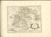
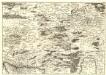
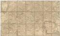
163 Fulda, uit: Topographische Special-Karte von Deutschland (von Central-Europa) / begründet von D.G. Reymann ; [entworfen und gezeichn. von Heinrich Berghaus... [et al.]]

1 : 200000 Annotatie: Lit.: Daniel Gottlob Reymann und die "Topographische Special-Karte von Deutschland" / von Wolfgang Scharfe, in: Kartographische Nachrichten, 39 (1989), Heft I, p. 1-10; Handgeschreven titel: Reymann's Deutschland : 24 Sectionen: Jena, Penig, Dresden, Zittau, Hirschberg, Breslau, Brieg, Andernach, Coblenz, Giessen, Fulda, Schleusingen, Plauen, Zwickau, Teplitz, Jung Bunzlau, Hohenelbe, Glatz, Neisse, Simmern, Prag, Luxemburg, Birkenfeld; Aanwezig: 23 bladen Reymann, Daniel Gottlob; Berghaus, Heinrich [Berlin : 2. Departement des Kriegsministeriums, Bureau für Plan- und Kartenzeichnung]
$title$

126. Fulda, uit: Topographische Uebersichtskarte des Deutschen Reiches / herausgegeben v. d. Kartogr. Abt. d. Königl. Preuß. Landesaufnahme

1 : 200000 titelvariant: Topogr. Übersichtskarte des Deutschen Reiches; Annotatie: Titel boven bladen ook: Topogr. Übersichtskarte des Deutschen Reiches; Annotatie geografische gegevens: Op elk blad twee maatstokken: 10 Kilometer = 5,5 cm; 1 geogr. Meile = 3,6 cm; Legenda onder op elk blad Königlich Preußische Landesaufnahme. Kartographische Abtheilung [S.l : Königlich Preußische Landesaufnahme, Kartographische Abtheilung]
$title$

Bvchaviae, siue Fvldensis ditionis typvs

1 Karte : Kupferdruck ; 30 x 21 cm Regerwyl; Ortelius s.n.
$title$

Section Giessen, uit: Charte von dem Grossherzogtum Hessen und dem Herzogtum Nassau / trigonometrisch aufgenommen und hrsg. von C.L.P. Eckhardt

1 : 200000 titelvariant: Karte von Hessen und Nassau Eckhardt, C. L. P Darmstadt : Joh. Wilh. Heyer
$title$

Delineatio Geographica generalis comprehendens VI. Foliis Singulos Principatvs Comitatvs Ditiones Dynastias omnes quotquot Imperio Serenissimi Principis Landgrafii Hasso-Darmstadiensis subsunt :

1 : 180000 Mollova mapová sbírka Bronner, Christian Maximilian Homann, Johann Baptista - dědici
$title$

$title$

Reverendissimo Et Celsissimo S. R. I. Principi Adolfo Sanctae Fuldensis Ecclesiae Abbati Augustissimae Romanorum Imperatricis Archi-Cancellario Per Germaniam Galliamque Primati hanc Eius Ditionis Simul Ac Dioecisis Tabulam Geographicam Monumentis Historicis Illustratam

1 : 230000 Mollova mapová sbírka Schannat, Johann Friedrich
$title$

S. R. I. Principatvs Fvldensis in Bvchonia

1 : 210000 Mollova mapová sbírka Homann, Johann Baptist Homann, Johann Baptista
$title$

S. R. I. Principatvs Fvldensis in Bvchonia

1 : 210000 Mollova mapová sbírka Homann, Johann Baptist Homann, Johann Baptista
$title$

S. R. Imp. comitatus Hanau

1 : 190000 Büdingen (Německo) Zollmann, Friedrich Homann, Johann Baptist J. B. Homann
$title$

S. R. Imp. comitatus Hanau

1 : 190000 Büdingen (Německo) Zollmann, Friedrich Homann, Johann Baptist J. B. Homann
$title$

Le Landgraviat de Hesse-Cassel Meridional et Septentr: avec une Partie du Landgraviat de Hesse-Darmstat et de la Vetteravie avec autres dependences

1 : 200000 Mollova mapová sbírka Carlet, Louis-François Lotter, Tobias Conrad
$title$

S.R.I. principatus Fuldensis in Buchonia

1 : 206000 Fulda (Německo) Homann, Johann Baptist Ioh. Baptista Homanno
$title$

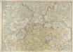
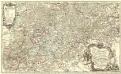
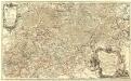
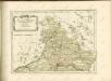
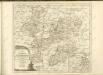
Wetteraviae Hanc Cum Confiniis Delineationem Serenissimo Principi Ac Domino, D[omi]no Ernesto Ludovico, Hassiae Landgravio, Principi Hersfeldiae, Comiti In Cattimeliboco, Decia, Ziegenhaina, Nidda, Schaumburg, Isemburgo Et Budinga, Etc. Domino suo clementißimo humilimè offert Ioh. Iacob Stetter, I. U. L.

Stetter, Johann Jakob; Stridbeck, Johann Hutter
$title$

Eisenach 86, uit: Special-Karte von Mittel-Europa / nach amtlichen Quellen bearbeitet von W. Liebenow

1 : 300000 titelvariant: W. Liebenow's Mittel-Europa; Annotatie: Titel boven de bladen: W. Liebenow's Mittel-Europa Johannes Wilhelm Liebenow 1822-1897 Frankfurt a. M. : Ludwig Ravenstein
$title$

Partie Méridionale du Langraviat de Hesse-Cassel avec une Partie de la Vetteravie

1 : 200000 Mollova mapová sbírka Carlet, Louis-François Coentgen, Heinrich Hugo Broenner, Heinrich Ludwig
$title$

Fulda

1 : 300000 R. Mittelbach
$title$

Partie Méridionale du Langraviat de Hesse-Cassel avec une Partie de la Vetteravie

1 : 200000 Mollova mapová sbírka Carlet, Louis-François Coentgen, Heinrich Hugo Broenner, Heinrich Ludwig
$title$

S. R. Imp. Circuli Franconici Geographica Delineatio Francken-Land mit Seinen Gräntzen

Mollova mapová sbírka Endter, Wolfgang Moritz Endter, Wolfgang Moritz
$title$

Wetteravia cum omnibus inclusis principatibus, comitatibus, dominiis et praefecturis et confinibus provinciis, accuratissime designata et juxta limites determinata

1 : 210000 Augstae Vindelicorum : studio et sumtibus Matthaei Seutteri
$title$

Partie méridionale du langraviat de Hesse-Cassel

Hesensko (Německo) Carlet, Louis-François Broglie, Victor-François de chez Henrii Louis Broenner
$title$

$title$

Reverendissimo Et Celsissimo S. R. I. Principi Constantino Sanctae Fuldensis Ecclesiae Abbati Augustissimae Romanorum Imperatricis Archi-Cancellario Per Germaniam Galliamque Primati Hanc Novam Veteris Buchoniae Tabulam Unacum Suis Confinys Dedicat Consecratque

1 : 340000 Mollova mapová sbírka Schannat, Johann Friedrich Puschner, Johann Georg
$title$

Buchaviae, sive Fuldensis Ditionis Typus. [Karte], in: Theatrum orbis terrarum, S. 236.

1 Karte aus Atlas Ortelius, Abraham Vrients, Jan Baptista
$title$

$title$

$title$

Kissingen 100, uit: Special-Karte von Mittel-Europa / nach amtlichen Quellen bearbeitet von W. Liebenow

1 : 300000 titelvariant: W. Liebenow's Mittel-Europa; Annotatie: Titel boven de bladen: W. Liebenow's Mittel-Europa Johannes Wilhelm Liebenow 1822-1897 Frankfurt a. M. : Ludwig Ravenstein
© MapTiler © OpenStreetMap contributors
How does it work?
These instructions will show you how to find historical maps online.
Getting started
Type the place name in the search box to find the exact location. You can further adjust the search by zooming in and out.
Zoom
Zoom in and out with the buttons or use your mouse or touchpad natively.
Exact Area tool
Click here and draw a rectangle over the map to precisely define the search area.
Set filters
Narrow your search with advanced settings, such as Years (from/to), Fulltext, Publisher, etc.
Results
See the results of your search on the right side. You can scroll down to find more maps of this location.
?

Download OldMapsOnline Mobile