Katalogisierte Karte
Cheshire XXXVII.10 (includes: Macclesfield Forest; Macclesfield; Rainow; Sutton) - 25 Inch Map


Einrichtung:National Library of Scotland
Vollständiger Titel:Cheshire XXXVII.10 (includes: Macclesfield Forest; Macclesfield; Rainow; Sutton) - 25 Inch Map
Jahr der Abbildung:1907
Veröffentlichungsdatum:1909
Herausgeber:Ordnance Survey
Maßstab der Karte:1:2 500
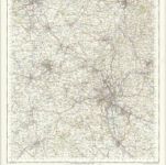
Stoke on Trent - OS One-Inch Map
1949
Ordnance Survey
1:63k
Macclesfield (Outline) - OS One-Inch Revised New Series
1895
Ordnance Survey
1:63k

Macclesfield (Hills) - OS One-Inch Revised New Series
1895
Ordnance Survey
1:63k

Stoke upon Trent (Outline) - OS One-Inch Revised New Series
1895
Ordnance Survey
1:63k

Stoke upon Trent (Hills) - OS One-Inch Revised New Series
1895
Ordnance Survey
1:63k
An accurate map of the county palatine of Chester
1765
Bowen; Hinton
Cestria comitatvs palatinvs
1690
Valck; Schenk
Cestria comitatvs palatinvs
1646
Blaeu

Stockport (Hills) - OS One-Inch Revised New Series
1895
Ordnance Survey
1:63k

Stockport (Outline) - OS One-Inch Revised New Series
1895
Ordnance Survey
1:63k