Innovative search engine which allows users to search through map catalogs across a number of institutions
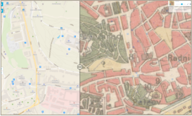
Compare historical maps to current data. Users can overlay historical maps on top of modern mapping data, giving a historical perspective on how cities and areas developed over time.
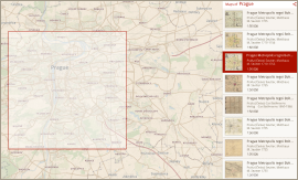
Allows the user to zoom and pan on a world map or type in a place name and instantly get a listing of maps available that most closely match the place and scale of map visible in the map viewer
A single entry point for searching maps of the same geographical location without the need to know which library holds the actual map. This is a real benefit for the general public, researchers, historians and students because it saves their time, effort and costs.
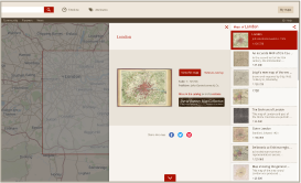
After finding a map, user doesn´t need to download a particular image. He can just click through to immediately see a full-sized online image of the historical map in a high resolution.

OldMapsOnline is a free public web application offered to the general public without any restrictions on access. No passwords are required as well.